
Crashy the Cold Front arrived in Texas yesterday, feeling as if it brought Canada along with it. Very cold weather will persist for the next few days, with the northern third of Texas remaining below freezing until lunchtime on Friday. Very localized lake effect snow bands will continue intermittently throughout the day, south of larger bodies of water. These are caused by the cold air being blown over comparatively warmer waters, inducing lift. A dusting of snow is possible; however, it will be a powdery snow that gets blown around easily.
Advertisements
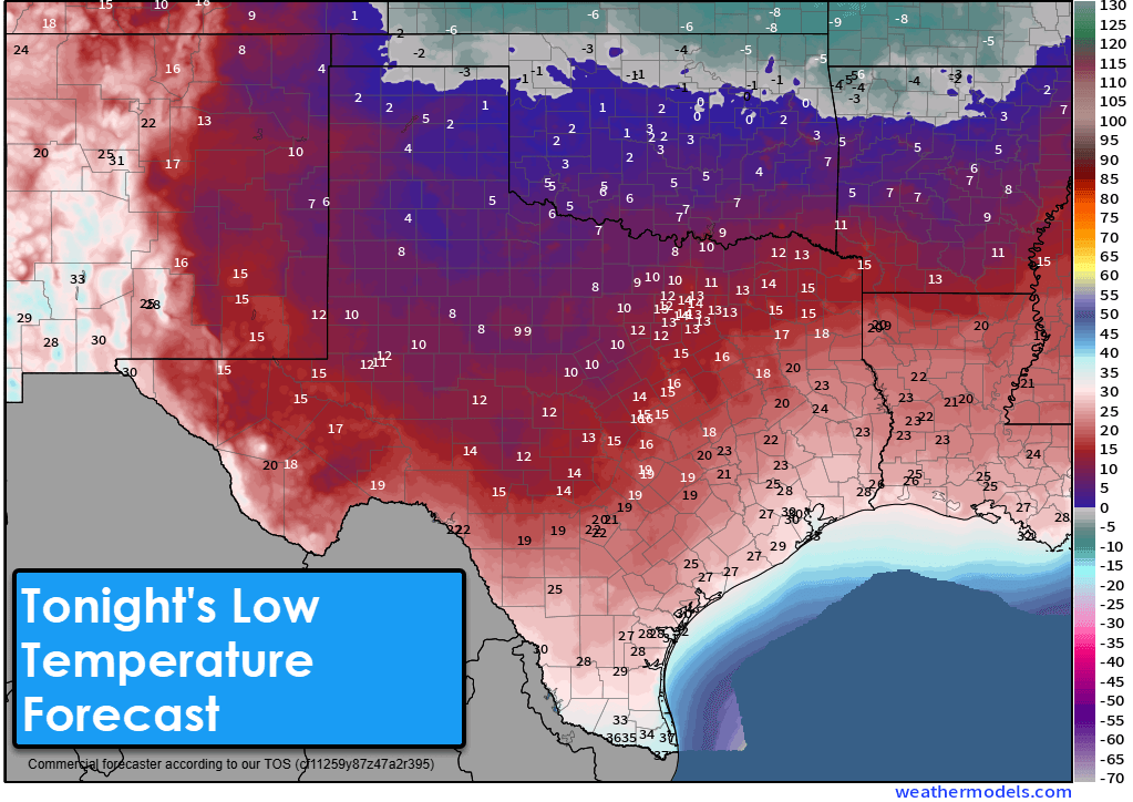

Temperatures tonight will plunge into the single digits, with wind chills below zero, across the northern forty percent of the state. Everyone except the Borderland, Deep South Texas, and the Rio Grande Valley will experience a freeze tonight and again Thursday night. It will be chilly to downright cold across much of Texas through Friday. An exception is the Borderland, which is being shielded from the cold front by the Davis and Guadalupe Mountains. Temperatures will be in the upper 60s every afternoon this week in El Paso. Please practice cold weather safety! You can find a nearby warming shelter at https://tdem.texas.gov/warm/. Wearing multiple layers will also help you maintain body heat.
Aside from our rogue lake effect snow bands, we will remain mostly dry through Friday. Light rain chances will return to the Rio Grande Valley on Friday, the southeastern half of Texas on Friday night, followed by a round of showers and storms for the eastern third of Texas from Saturday night into Sunday morning. No significant winter mischief, severe storms, or flooding appear to be on the horizon at this time.

A significant warm-up will commence this weekend as we shed our winter gear and return to short sleeves and shorts. High temperatures on Saturday will climb back into the 50s, 60s, and 70s statewide. By Sunday, we will all see temperatures in the 60s, 70s, and even 80s! An extended dry stretch of weather will begin following Sunday morning’s round of rain. Above-average, spring-like temperatures will continue for much of next week.
Helpful Links
Advertisements
Check out our current LIVE STREAM: https://texasweather.video/
Our FREE WEATHER APP: https://texasweather.app/
GET ALERTED when in danger of severe storms and tornadoes! https://weathercallservices.com/tx-storm-chasers-nexgen
Our SOCIAL PLATFORMS: https://linktr.ee/texasstormchasers