
There is a significant risk of severe thunderstorms this afternoon and evening across Kansas, Oklahoma, and Northern Texas. Sunday’s round of storms already brought multiple significant tornadoes to these regions, and today is shaping up to be another busy day in terms of severe weather.
However, just because we are facing a substantial risk does not mean that everyone will be impacted. There are some mitigating factors in today’s weather forecast that could reduce both the severity and frequency of storms. It’s important not to assume that issues are guaranteed in Texas today. While the projected conditions support a significant risk of severe storms, including tornadoes, in North Texas and Texoma, not all data indicates that storms will take advantage of this dangerous environment.
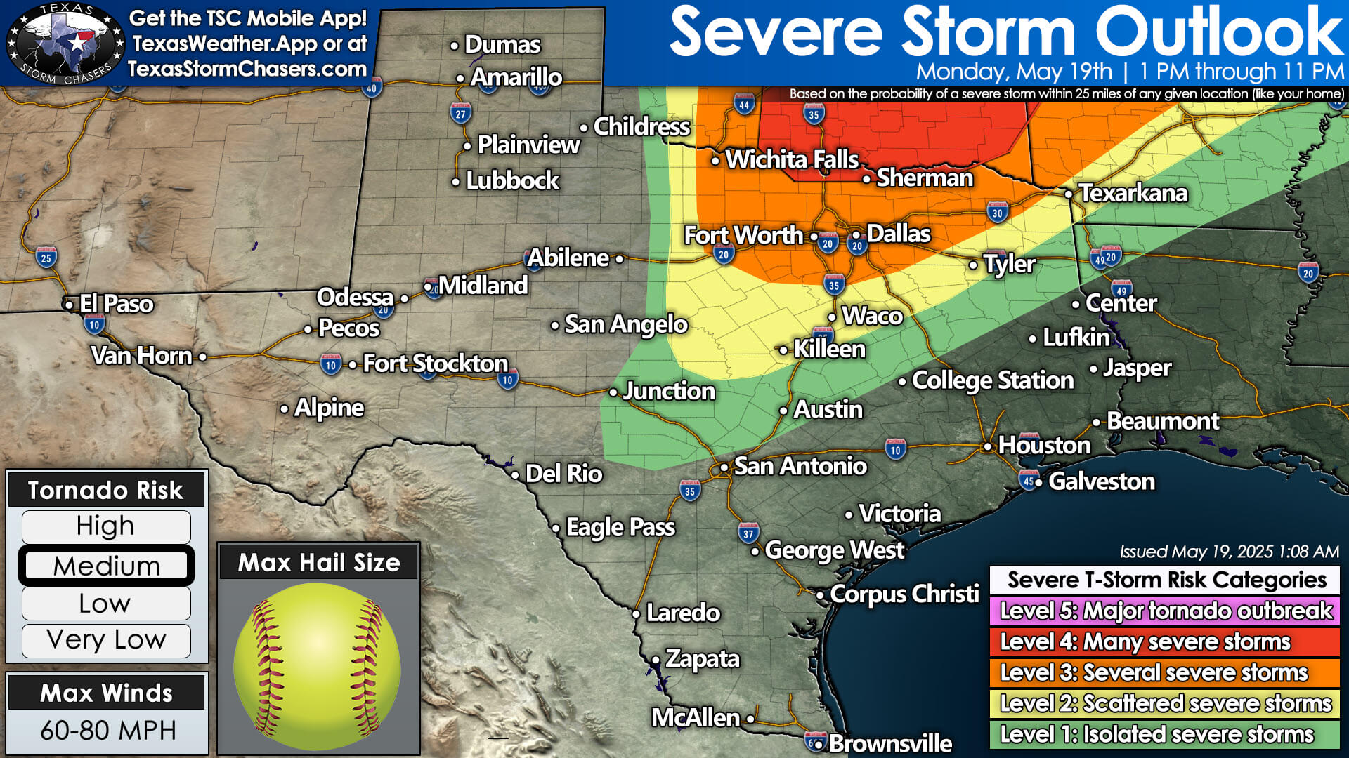

Some data suggests that only one or two storms may develop this afternoon, primarily near the Red River, with these storms moving northeast into Oklahoma. Other models indicate a possibility of more storms developing in North Texas, which could form a line or cluster, resulting in hail, strong winds, and spin-up tornadoes—but presenting a lower risk than the discrete storms we saw yesterday.
There are also indications of a volatile severe weather setup across Texoma, North Texas, and even Northeast Texas that could lead to multiple long-track severe storms, including tornadoes. I’m cautious about relying on any single model, as weather predictions have struggled to perform well over the past week. Nevertheless, the potential for a busy severe weather day still exists.
Throughout the day, we will closely monitor the sky and use satellite data to pinpoint details such as the location of the dryline and any leftover outflow boundaries from yesterday’s storms. We’ll also be watching to see if a morning round of storms develops, which may bring hail and wind but with a much lower tornado risk, or if conditions remain stable until the afternoon.
Key questions include where storms will initiate this afternoon: will it be west of Interstate 35 near Highway 281, closer to the D/FW Metroplex, or just east? We aim to provide answers to these questions as we progress into the late morning and early afternoon.
My main message to everyone is to maintain situational awareness. Keep an eye on the sky, and ensure you have a way to receive severe weather warnings. Nearly our entire team will be chasing today, while those who aren’t will help provide live severe weather coverage. If tornado warnings are issued, we will have live updates on our YouTube channel, Texas Storm Chasers’ Facebook, Twitch, X, on our website at https://texasstormchasers.com/live, and on our weather blog at https://texasstormchasers.com. You can also find updates in our free Texas Storm Chasers mobile app at https://texasstormchasers.app.
After today, a cool front is expected to bring lower humidity and cooler weather to much of Texas on Tuesday. We will gradually warm back up to typical May temperatures by mid-week, but overall, the chances for thunderstorms seem to remain low for several days.
VIDEO CHAPTERS:
00:00 – Introduction
01:17 – Texas Severe Storm Risk Today
04:05 – Solution 1 (HRRR model)
05:21 – Solution 2 (NAM model)
06:12 – Solution 3 (HRW FV3 model)
07:28 – Baldy’s Expecations for Today (Timing/Threads)
11:38 – Tuesday through Friday’s Weather
12:30 – Baldyinchiefisms & Conclusion