
Severe weather is expected in several regions of Texas over the next few days. Multiple rounds of thunderstorms, some of which may cause serious weather and flooding, will affect areas such as West Texas, northwest Texas, the Big Country, Texoma, North Texas, the Concho Valley, and the Permian Basin.
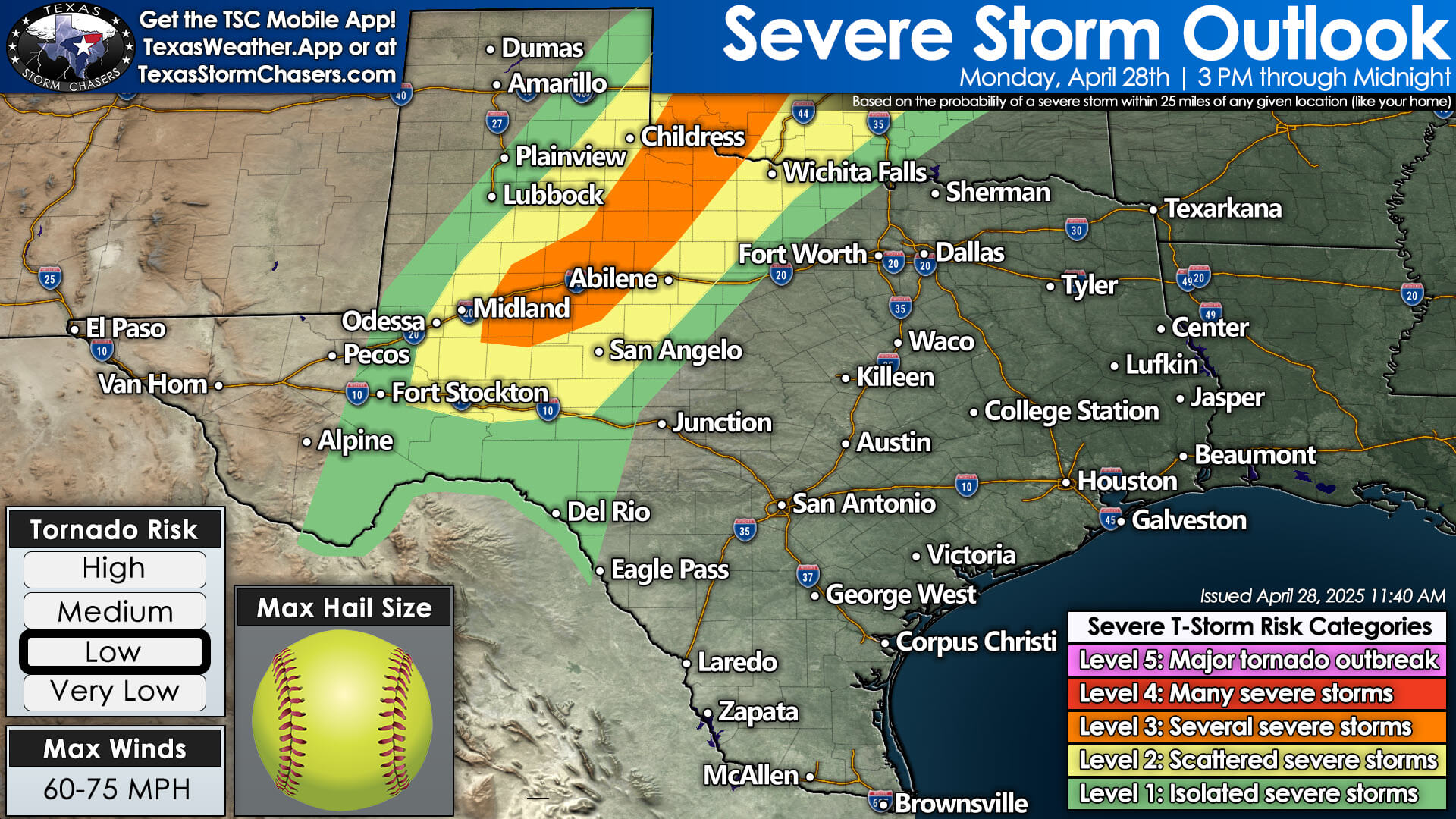

The first round of thunderstorms is likely to develop after 3:00 PM today, east of a dry line in northwest Texas and West Central Texas, moving south into the Permian Basin. These initial storms will have strong updrafts, and the most intense ones could produce very large hail—up to the size of softballs—along with damaging winds and the possibility of tornadoes. The storms will move east-northeast at speeds of 20 to 30 mph. While not every storm will produce giant hail or cause major damage, it’s late April and early May in Texas, and the weather is becoming more active.
The chance of thunderstorms will continue into the late evening hours in northwest Texas and Texoma, with storms moving eastward. Severe weather may extend into parts of North Texas and Texoma late tonight, but the storm activity will likely weaken as we approach and move past midnight.
Severe Storms Likely again on Tuesday
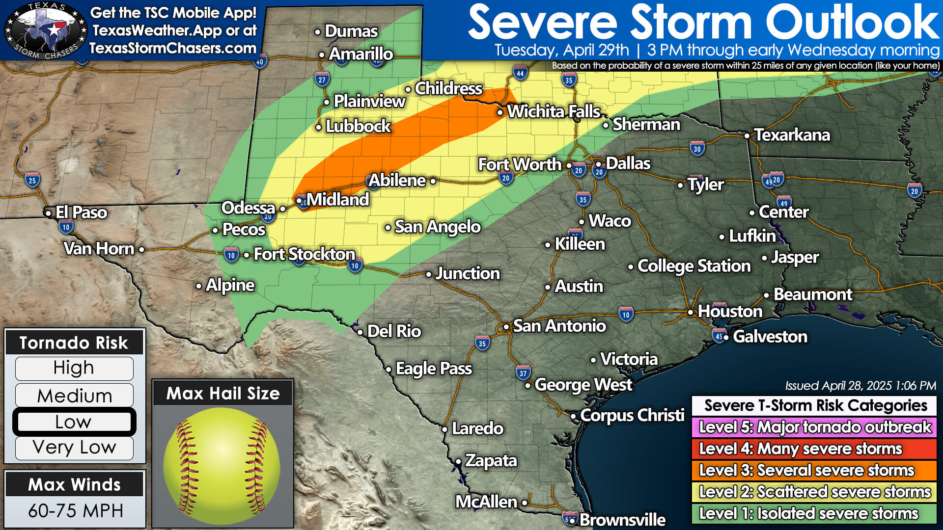

Severe thunderstorms will likely return on Tuesday, affecting many of the same areas. However, the storms may start 50 to 80 miles further west than today, putting more of West Texas at risk. Similar to today, storms are expected to develop after 3:00 PM, and the strongest storms could again produce large hail, damaging winds, heavy rain, and a few tornadoes. Unlike today, there is a higher chance that thunderstorms will continue well into Tuesday night and early Wednesday morning. This could lead to significant flash flooding and more severe storms in West Texas, the Big Country, and northwest Texas on Wednesday morning.
Flooding also a concern!
The risk of flooding is expected to increase on Tuesday and Wednesday due to several rounds of heavy thunderstorms. On Wednesday, storm chances are expected to shift farther east, as a group of storms may move into North Texas by Wednesday morning. New thunderstorms may also form in North Texas and northeast Texas on Wednesday afternoon, especially southeast of areas that have already seen storms.
Wednesday’s Storm Threat
Severe weather could happen again on Wednesday, but we’ll need to see how things develop after the storms today and tomorrow. We will focus on Wednesday and beyond after we get through today and tomorrow. It’s going to be a busy week with potentially serious thunderstorms, but there’s hope that the rain will help areas that need it. Sadly, some places may get too much rain in a short time, leading to flooding. The long-range precipitation outlook from the Climate Prediction Center shows a good chance for rain across all of Texas through the first week of May. While we may have a calmer day on Thursday, it looks like thunderstorms will continue into the weekend, including areas farther south, such as the Concho Valley, Edwards Plateau, and Hill Country.