SPC – No watches are valid as of Mon May 13 00:02:01 UTC 2024
No watches are valid as of Mon May 13 00:02:01 UTC 2024.
24/7 Tornado Newsfeed
No watches are valid as of Mon May 13 00:02:01 UTC 2024.
WW 233 TORNADO LA TX CW 121730Z – 130000Z 
 URGENT - IMMEDIATE BROADCAST REQUESTED
Tornado Watch Number 233
NWS Storm Prediction Center Norman OK
1230 PM CDT Sun May 12 2024 The NWS Storm Prediction Center has issued a * Tornado Watch for portions of Southwest Louisiana Southeast Texas Coastal Waters * Effective this Sunday afternoon and evening from 1230 PM until 700 PM CDT. * Primary threats include... A couple tornadoes possible Scattered large hail and isolated very large hail events to 2 inches in diameter possible SUMMARY...The threat for supercells with a couple of tornadoes will
slowly increase through the afternoon as a warm front moves slowly
northward across southeast Texas and southwest Louisiana. The
tornado threat will be greater with storms along the warm front. Storms along and to the cool side of the front will pose a threat
for large hail of 1-2 inches in diameter, as well as isolated
damaging gusts of 60-70 mph. The tornado watch area is approximately along and 35 statute miles
north and south of a line from 120 miles west of Port Arthur TX to
35 miles east northeast of Lake Charles LA. For a complete depiction
of the watch see the associated watch outline update (WOUS64 KWNS
WOU3). PRECAUTIONARY/PREPAREDNESS ACTIONS... REMEMBER...A Tornado Watch means conditions are favorable for
tornadoes and severe thunderstorms in and close to the watch
area. Persons in these areas should be on the lookout for
threatening weather conditions and listen for later statements
and possible warnings. && OTHER WATCH INFORMATION...CONTINUE...WW 232... AVIATION...Tornadoes and a few severe thunderstorms with hail
surface and aloft to 2 inches. Extreme turbulence and surface wind
gusts to 60 knots. A few cumulonimbi with maximum tops to 550. Mean
storm motion vector 26025. ...Thompson
WW 232 SEVERE TSTM TX 121400Z – 122000Z 
 URGENT - IMMEDIATE BROADCAST REQUESTED
Severe Thunderstorm Watch Number 232
NWS Storm Prediction Center Norman OK
900 AM CDT Sun May 12 2024 The NWS Storm Prediction Center has issued a * Severe Thunderstorm Watch for portions of Central and east Texas * Effective this Sunday morning and afternoon from 900 AM until 300 PM CDT. * Primary threats include... Scattered large hail and isolated very large hail events to 2 inches in diameter possible Isolated damaging wind gusts to 70 mph possible SUMMARY...Clusters of slightly elevated thunderstorms, including
embedded supercells, may persist through early afternoon while
spreading eastward. The storm environment will favor the potential
for occasional large hail of 1-2 inches in diameter and isolated
damaging gusts of 60-70 mph. The severe thunderstorm watch area is approximately along and 35
statute miles north and south of a line from 5 miles south southwest
of Temple TX to 5 miles east southeast of Lufkin TX. For a complete
depiction of the watch see the associated watch outline update
(WOUS64 KWNS WOU2). PRECAUTIONARY/PREPAREDNESS ACTIONS... REMEMBER...A Severe Thunderstorm Watch means conditions are
favorable for severe thunderstorms in and close to the watch area.
Persons in these areas should be on the lookout for threatening
weather conditions and listen for later statements and possible
warnings. Severe thunderstorms can and occasionally do produce
tornadoes. && AVIATION...A few severe thunderstorms with hail surface and aloft to
2 inches. Extreme turbulence and surface wind gusts to 60 knots. A
few cumulonimbi with maximum tops to 550. Mean storm motion vector
28030. ...Thompson
No watches are valid as of Sat May 11 01:02:02 UTC 2024.
WW 231 SEVERE TSTM NC SC CW 101750Z – 110100Z 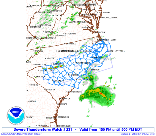
 URGENT - IMMEDIATE BROADCAST REQUESTED
Severe Thunderstorm Watch Number 231
NWS Storm Prediction Center Norman OK
150 PM EDT Fri May 10 2024 The NWS Storm Prediction Center has issued a * Severe Thunderstorm Watch for portions of Southern and eastern North Carolina Northern and northeastern South Carolina Coastal Waters * Effective this Friday afternoon and evening from 150 PM until 900 PM EDT. * Primary threats include... Scattered damaging wind gusts to 70 mph possible Scattered large hail events to 1.5 inches in diameter possible SUMMARY...Scattered thunderstorm development is expected along and
ahead of a weak cold front/surface trough, starting near the North
Carolina/South Carolina border and then spreading eastward and
southeastward through the evening. The storm environment will favor
a mix of supercells and bowing segments capable of producing large
hail of 1-1.5 inches in diameter and damaging gusts of 60-70 mph. The severe thunderstorm watch area is approximately along and 60
statute miles north and south of a line from 55 miles south of
Charlotte NC to 30 miles south southeast of Cape Hatteras NC. For a
complete depiction of the watch see the associated watch outline
update (WOUS64 KWNS WOU1). PRECAUTIONARY/PREPAREDNESS ACTIONS... REMEMBER...A Severe Thunderstorm Watch means conditions are
favorable for severe thunderstorms in and close to the watch area.
Persons in these areas should be on the lookout for threatening
weather conditions and listen for later statements and possible
warnings. Severe thunderstorms can and occasionally do produce
tornadoes. && AVIATION...A few severe thunderstorms with hail surface and aloft to
1.5 inches. Extreme turbulence and surface wind gusts to 60 knots. A
few cumulonimbi with maximum tops to 500. Mean storm motion vector
29030. ...Thompson
No watches are valid as of Fri May 10 15:13:01 UTC 2024.