SPC
SPC Severe Thunderstorm Watch 238
WW 238 SEVERE TSTM TX CW 132135Z – 140300Z 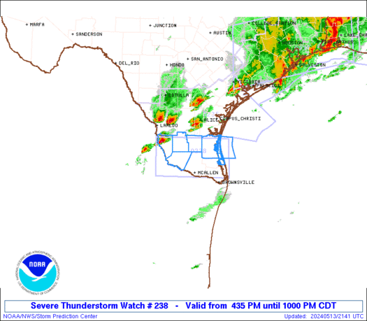
 URGENT - IMMEDIATE BROADCAST REQUESTED
Severe Thunderstorm Watch Number 238
NWS Storm Prediction Center Norman OK
435 PM CDT Mon May 13 2024 The NWS Storm Prediction Center has issued a * Severe Thunderstorm Watch for portions of Deep South Texas Coastal Waters * Effective this Monday afternoon and evening from 435 PM until 1000 PM CDT. * Primary threats include... Scattered large hail and isolated very large hail events to 2 inches in diameter possible Isolated damaging wind gusts to 70 mph possible SUMMARY...Thunderstorms will build/move southeastward into deep
south Texas this evening, with a few cells posing a risk of damaging
winds and large hail. The severe thunderstorm watch area is approximately along and 40
statute miles north and south of a line from 85 miles west northwest
of Mcallen TX to 75 miles east northeast of Mcallen TX. For a
complete depiction of the watch see the associated watch outline
update (WOUS64 KWNS WOU8). PRECAUTIONARY/PREPAREDNESS ACTIONS... REMEMBER...A Severe Thunderstorm Watch means conditions are
favorable for severe thunderstorms in and close to the watch area.
Persons in these areas should be on the lookout for threatening
weather conditions and listen for later statements and possible
warnings. Severe thunderstorms can and occasionally do produce
tornadoes. && OTHER WATCH INFORMATION...CONTINUE...WW 236...WW 237... AVIATION...A few severe thunderstorms with hail surface and aloft to
2 inches. Extreme turbulence and surface wind gusts to 60 knots. A
few cumulonimbi with maximum tops to 500. Mean storm motion vector
29030. ...Hart
SPC Severe Thunderstorm Watch 237
WW 237 SEVERE TSTM LA TX CW 131800Z – 140100Z 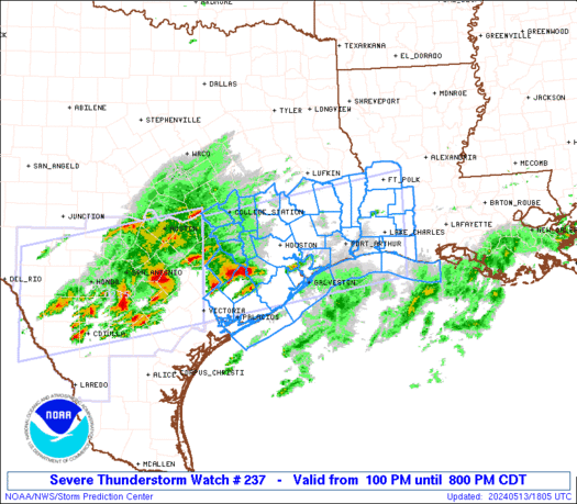
 URGENT - IMMEDIATE BROADCAST REQUESTED
Severe Thunderstorm Watch Number 237
NWS Storm Prediction Center Norman OK
100 PM CDT Mon May 13 2024 The NWS Storm Prediction Center has issued a * Severe Thunderstorm Watch for portions of Southwest Louisiana Southeast Texas Coastal Waters * Effective this Monday afternoon and evening from 100 PM until 800 PM CDT. * Primary threats include... Scattered damaging winds and isolated significant gusts to 80 mph likely Scattered large hail and isolated very large hail events to 3 inches in diameter likely A tornado or two possible SUMMARY...Clusters of storms are expected to move and develop
eastward into southeast Texas and southwest Louisiana through this
evening. The storm environment favors a mix of supercells capable
of producing very large hail up to 3 inches in diameter, as well as
some upscale growth into clusters/bowing segments with the potential
for damaging winds of 60-80 mph. A tornado or two could occur with
favorable storm/boundary interactions. The severe thunderstorm watch area is approximately along and 65
statute miles north and south of a line from 50 miles north of
Victoria TX to 25 miles east northeast of Lake Charles LA. For a
complete depiction of the watch see the associated watch outline
update (WOUS64 KWNS WOU7). PRECAUTIONARY/PREPAREDNESS ACTIONS... REMEMBER...A Severe Thunderstorm Watch means conditions are
favorable for severe thunderstorms in and close to the watch area.
Persons in these areas should be on the lookout for threatening
weather conditions and listen for later statements and possible
warnings. Severe thunderstorms can and occasionally do produce
tornadoes. && OTHER WATCH INFORMATION...CONTINUE...WW 235...WW 236... AVIATION...A few severe thunderstorms with hail surface and aloft to
3 inches. Extreme turbulence and surface wind gusts to 70 knots. A
few cumulonimbi with maximum tops to 600. Mean storm motion vector
27030. ...Thompson
SPC Tornado Watch 236
WW 236 TORNADO FL CW 131550Z – 132300Z 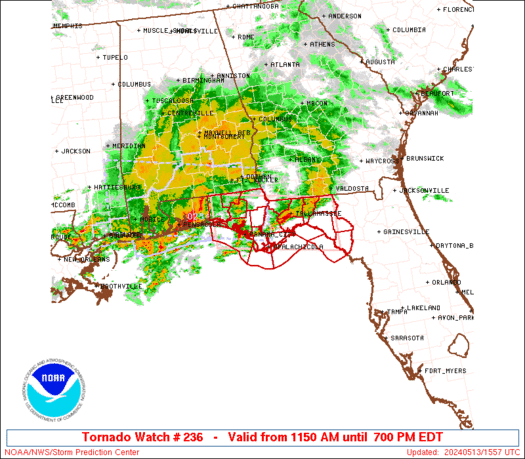
 URGENT - IMMEDIATE BROADCAST REQUESTED
Tornado Watch Number 236
NWS Storm Prediction Center Norman OK
1150 AM EDT Mon May 13 2024 The NWS Storm Prediction Center has issued a * Tornado Watch for portions of The Florida Panhandle Coastal Waters * Effective this Monday morning and evening from 1150 AM until 700 PM EDT. * Primary threats include... A couple tornadoes possible Scattered damaging winds likely with isolated significant gusts to 75 mph possible Isolated large hail events to 1.5 inches in diameter possible SUMMARY...A small bowing cluster will continue eastward this
afternoon across parts of the FL Panhandle, while posing a threat
for a few tornadoes and scattered severe/damaging winds of 60-75
mph. The tornado watch area is approximately along and 40 statute miles
north and south of a line from 40 miles west northwest of Panama
City FL to 70 miles east southeast of Tallahassee FL. For a complete
depiction of the watch see the associated watch outline update
(WOUS64 KWNS WOU6). PRECAUTIONARY/PREPAREDNESS ACTIONS... REMEMBER...A Tornado Watch means conditions are favorable for
tornadoes and severe thunderstorms in and close to the watch
area. Persons in these areas should be on the lookout for
threatening weather conditions and listen for later statements
and possible warnings. && OTHER WATCH INFORMATION...CONTINUE...WW 234...WW 235... AVIATION...Tornadoes and a few severe thunderstorms with hail
surface and aloft to 1.5 inches. Extreme turbulence and surface wind
gusts to 65 knots. A few cumulonimbi with maximum tops to 500. Mean
storm motion vector 27035. ...Gleason
SPC Severe Thunderstorm Watch 235
WW 235 SEVERE TSTM TX 131350Z – 132100Z 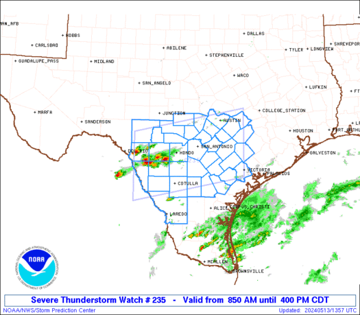
 URGENT - IMMEDIATE BROADCAST REQUESTED
Severe Thunderstorm Watch Number 235
NWS Storm Prediction Center Norman OK
850 AM CDT Mon May 13 2024 The NWS Storm Prediction Center has issued a * Severe Thunderstorm Watch for portions of South central Texas * Effective this Monday morning and afternoon from 850 AM until 400 PM CDT. * Primary threats include... Widespread large hail and isolated very large hail events to 3 inches in diameter likely Scattered damaging wind gusts to 70 mph likely SUMMARY...Scattered supercell development is expected this morning
and the storms will likely persist into this afternoon while
spreading eastward and increasing in coverage. Very large hail up
to 3 inches in diameter and severe outflow gusts of 60-70 mph will
be the primary hazards. The severe thunderstorm watch area is approximately along and 70
statute miles north and south of a line from 90 miles west northwest
of Cotulla TX to 55 miles north of Victoria TX. For a complete
depiction of the watch see the associated watch outline update
(WOUS64 KWNS WOU5). PRECAUTIONARY/PREPAREDNESS ACTIONS... REMEMBER...A Severe Thunderstorm Watch means conditions are
favorable for severe thunderstorms in and close to the watch area.
Persons in these areas should be on the lookout for threatening
weather conditions and listen for later statements and possible
warnings. Severe thunderstorms can and occasionally do produce
tornadoes. && OTHER WATCH INFORMATION...CONTINUE...WW 234... AVIATION...A few severe thunderstorms with hail surface and aloft to
3 inches. Extreme turbulence and surface wind gusts to 60 knots. A
few cumulonimbi with maximum tops to 600. Mean storm motion vector
27025. ...Thompson
SPC Severe Thunderstorm Watch 234
WW 234 SEVERE TSTM AL FL MS CW 131000Z – 131600Z 
 URGENT - IMMEDIATE BROADCAST REQUESTED
Severe Thunderstorm Watch Number 234
NWS Storm Prediction Center Norman OK
500 AM CDT Mon May 13 2024 The NWS Storm Prediction Center has issued a * Severe Thunderstorm Watch for portions of Southern Alabama Florida Panhandle Far Southern Mississippi Coastal Waters * Effective this Monday morning from 500 AM until 1100 AM CDT. * Primary threats include... Scattered damaging winds and isolated significant gusts to 75 mph possible Isolated large hail events to 1.5 inches in diameter possible A tornado or two possible SUMMARY...Clusters of east/southeastward-moving storms will likely
intensify this morning along and north of a northward-shifting warm
front. The severe thunderstorm watch area is approximately along and 55
statute miles north and south of a line from 55 miles northwest of
Mobile AL to 20 miles southeast of Marianna FL. For a complete
depiction of the watch see the associated watch outline update
(WOUS64 KWNS WOU4). PRECAUTIONARY/PREPAREDNESS ACTIONS... REMEMBER...A Severe Thunderstorm Watch means conditions are
favorable for severe thunderstorms in and close to the watch area.
Persons in these areas should be on the lookout for threatening
weather conditions and listen for later statements and possible
warnings. Severe thunderstorms can and occasionally do produce
tornadoes. && AVIATION...A few severe thunderstorms with hail surface and aloft to
1.5 inches. Extreme turbulence and surface wind gusts to 65 knots. A
few cumulonimbi with maximum tops to 500. Mean storm motion vector
28040. ...Guyer