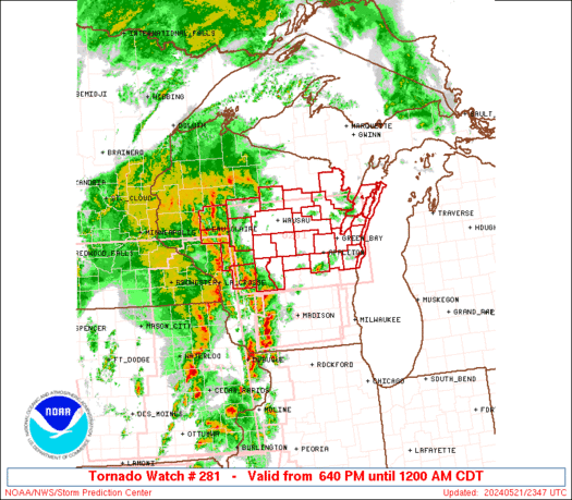
SPC
SPC Tornado Watch 288
WW 288 TORNADO TX 182130Z – 190300Z 
 URGENT - IMMEDIATE BROADCAST REQUESTED
Tornado Watch Number 288
NWS Storm Prediction Center Norman OK
430 PM CDT Sun May 18 2025 The NWS Storm Prediction Center has issued a * Tornado Watch for portions of West-Central into North-Central Texas * Effective this Sunday afternoon and evening from 430 PM until 1000 PM CDT. * Primary threats include... A few tornadoes likely with a couple intense tornadoes possible Scattered large hail and isolated very large hail events to 3 inches in diameter likely Scattered damaging wind gusts to 70 mph possible SUMMARY...Supercells will continue to rapidly develop and pose a
threat for both a few tornadoes and large to very large hail this
afternoon and evening as they move east-northeastward. The largest
hailstones may reach up to 2-3 inches in diameter. A strong tornado
may occur with any persistent supercell this evening as low-level
shear increases. The tornado watch area is approximately along and 60 statute miles
east and west of a line from 15 miles southwest of Brownwood TX to
25 miles north northwest of Wichita Falls TX. For a complete
depiction of the watch see the associated watch outline update
(WOUS64 KWNS WOU8). PRECAUTIONARY/PREPAREDNESS ACTIONS... REMEMBER...A Tornado Watch means conditions are favorable for
tornadoes and severe thunderstorms in and close to the watch
area. Persons in these areas should be on the lookout for
threatening weather conditions and listen for later statements
and possible warnings. && OTHER WATCH INFORMATION...CONTINUE...WW 286...WW 287... AVIATION...Tornadoes and a few severe thunderstorms with hail
surface and aloft to 3 inches. Extreme turbulence and surface wind
gusts to 60 knots. A few cumulonimbi with maximum tops to 550. Mean
storm motion vector 25030. ...Gleason
SPC Tornado Watch 287
WW 287 TORNADO KS OK TX 182040Z – 190300Z 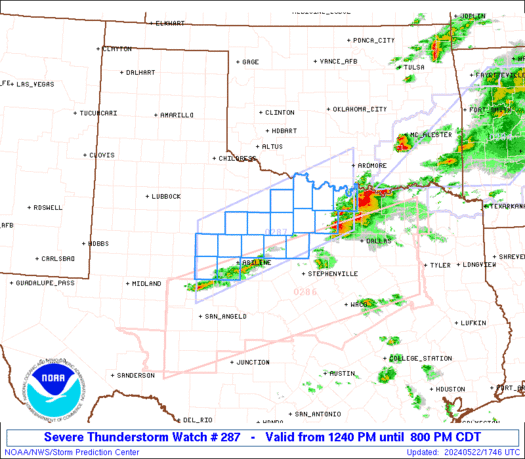
 URGENT - IMMEDIATE BROADCAST REQUESTED
Tornado Watch Number 287
NWS Storm Prediction Center Norman OK
340 PM CDT Sun May 18 2025 The NWS Storm Prediction Center has issued a * Tornado Watch for portions of South Central Kansas Western and Central Oklahoma Northeast Texas Panhandle * Effective this Sunday afternoon and evening from 340 PM until 1000 PM CDT. * Primary threats include... A few tornadoes and a couple intense tornadoes likely Widespread large hail and scattered very large hail events to 3 inches in diameter likely Scattered damaging wind gusts to 70 mph possible SUMMARY...Supercell thunderstorms are expected to rapidly intensify
along a dryline and warm front and spread across the watch area
through the evening. Very large hail and a few tornadoes are
possible. The tornado watch area is approximately along and 80 statute miles
east and west of a line from 45 miles west northwest of Russell KS
to 25 miles south southwest of Fort Sill OK. For a complete
depiction of the watch see the associated watch outline update
(WOUS64 KWNS WOU7). PRECAUTIONARY/PREPAREDNESS ACTIONS... REMEMBER...A Tornado Watch means conditions are favorable for
tornadoes and severe thunderstorms in and close to the watch
area. Persons in these areas should be on the lookout for
threatening weather conditions and listen for later statements
and possible warnings. && OTHER WATCH INFORMATION...CONTINUE...WW 286... AVIATION...Tornadoes and a few severe thunderstorms with hail
surface and aloft to 3 inches. Extreme turbulence and surface wind
gusts to 60 knots. A few cumulonimbi with maximum tops to 500. Mean
storm motion vector 25030. ...Hart
SPC – No watches are valid as of Sun May 18 16:17:02 UTC 2025
No watches are valid as of Sun May 18 16:17:02 UTC 2025.
SPC Severe Thunderstorm Watch 283
WW 283 SEVERE TSTM AR OK 180250Z – 180900Z 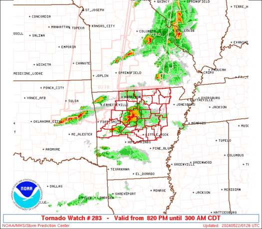
 URGENT - IMMEDIATE BROADCAST REQUESTED
Severe Thunderstorm Watch Number 283
NWS Storm Prediction Center Norman OK
950 PM CDT Sat May 17 2025 The NWS Storm Prediction Center has issued a * Severe Thunderstorm Watch for portions of Far Western Arkansas Central and Eastern Oklahoma * Effective this Saturday night and Sunday morning from 950 PM until 400 AM CDT. * Primary threats include... Scattered large hail and isolated very large hail events to 2 inches in diameter possible Scattered damaging wind gusts to 70 mph possible A tornado or two possible SUMMARY...Mainly elevated thunderstorms should continue to pose a
threat for large hail this evening into the early overnight hours.
The largest hailstones may reach up to 1-2 inches in diameter. There
is also some chance for a cluster of thunderstorms to form over the
next few hours. If this occurs, then the threat for severe/damaging
winds would increase as well. The severe thunderstorm watch area is approximately along and 50
statute miles north and south of a line from 55 miles northwest of
Chickasha OK to 5 miles east southeast of Fort Smith AR. For a
complete depiction of the watch see the associated watch outline
update (WOUS64 KWNS WOU3). PRECAUTIONARY/PREPAREDNESS ACTIONS... REMEMBER...A Severe Thunderstorm Watch means conditions are
favorable for severe thunderstorms in and close to the watch area.
Persons in these areas should be on the lookout for threatening
weather conditions and listen for later statements and possible
warnings. Severe thunderstorms can and occasionally do produce
tornadoes. && OTHER WATCH INFORMATION...CONTINUE...WW 279...WW 280...WW
281...WW 282... AVIATION...A few severe thunderstorms with hail surface and aloft to
2 inches. Extreme turbulence and surface wind gusts to 60 knots. A
few cumulonimbi with maximum tops to 550. Mean storm motion vector
28035. ...Gleason
SPC Severe Thunderstorm Watch 282
WW 282 SEVERE TSTM AR LA OK TX 180045Z – 180700Z 
 URGENT - IMMEDIATE BROADCAST REQUESTED
Severe Thunderstorm Watch Number 282
NWS Storm Prediction Center Norman OK
745 PM CDT Sat May 17 2025 The NWS Storm Prediction Center has issued a * Severe Thunderstorm Watch for portions of Southwest and South-Central Arkansas Northern Louisiana Far Southeast Oklahoma Northeast Texas * Effective this Saturday night and Sunday morning from 745 PM until 200 AM CDT. * Primary threats include... Scattered large hail and isolated very large hail events to 2.5 inches in diameter possible Scattered damaging wind gusts to 70 mph possible A tornado or two possible SUMMARY...Multiple clusters and supercells should spread generally
eastward this evening and overnight while posing a threat for both
large hail around 1.5-2.5 inches in diameter and severe/damaging
winds up to 60-70 mph. A tornado or two may also occur. The severe thunderstorm watch area is approximately along and 80
statute miles north and south of a line from 65 miles north
northwest of Longview TX to 30 miles north of Monroe LA. For a
complete depiction of the watch see the associated watch outline
update (WOUS64 KWNS WOU2). PRECAUTIONARY/PREPAREDNESS ACTIONS... REMEMBER...A Severe Thunderstorm Watch means conditions are
favorable for severe thunderstorms in and close to the watch area.
Persons in these areas should be on the lookout for threatening
weather conditions and listen for later statements and possible
warnings. Severe thunderstorms can and occasionally do produce
tornadoes. && OTHER WATCH INFORMATION...CONTINUE...WW 278...WW 279...WW
280...WW 281... AVIATION...A few severe thunderstorms with hail surface and aloft to
2.5 inches. Extreme turbulence and surface wind gusts to 60 knots. A
few cumulonimbi with maximum tops to 550. Mean storm motion vector
27035. ...Gleason