SPC
SPC Severe Thunderstorm Watch 247
WW 247 SEVERE TSTM KS OK 152255Z – 160600Z 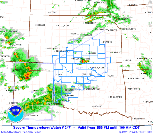
 URGENT - IMMEDIATE BROADCAST REQUESTED
Severe Thunderstorm Watch Number 247
NWS Storm Prediction Center Norman OK
555 PM CDT Wed May 15 2024 The NWS Storm Prediction Center has issued a * Severe Thunderstorm Watch for portions of South-Central Kansas Western and Northern Oklahoma * Effective this Wednesday afternoon and Thursday morning from 555 PM until 100 AM CDT. * Primary threats include... Scattered damaging winds and isolated significant gusts to 80 mph likely Scattered large hail and isolated very large hail events to 2.5 inches in diameter likely A tornado or two possible SUMMARY...Several clusters of strong to severe thunderstorms are
forecast to develop this evening across western into northern
Oklahoma and into south-central Kansas. The environment will
support a mix of supercells and organized linear clusters. A threat
for large to very large hail will seemingly be greatest through the
mid evening with any supercells. A non-zero risk for a tornado this
evening may focus over far northern Oklahoma and southern Kansas. By mid to late evening, the risk for severe gusts will likely become
the primary severe hazard. The severe thunderstorm watch area is approximately along and 90
statute miles north and south of a line from 55 miles northwest of
Clinton OK to 40 miles south southeast of Emporia KS. For a complete
depiction of the watch see the associated watch outline update
(WOUS64 KWNS WOU7). PRECAUTIONARY/PREPAREDNESS ACTIONS... REMEMBER...A Severe Thunderstorm Watch means conditions are
favorable for severe thunderstorms in and close to the watch area.
Persons in these areas should be on the lookout for threatening
weather conditions and listen for later statements and possible
warnings. Severe thunderstorms can and occasionally do produce
tornadoes. && OTHER WATCH INFORMATION...CONTINUE...WW 245...WW 246... AVIATION...A few severe thunderstorms with hail surface and aloft to
2.5 inches. Extreme turbulence and surface wind gusts to 70 knots. A
few cumulonimbi with maximum tops to 500. Mean storm motion vector
24035. ...Smith
SPC Severe Thunderstorm Watch 246
WW 246 SEVERE TSTM OK TX 152035Z – 160300Z 
 URGENT - IMMEDIATE BROADCAST REQUESTED
Severe Thunderstorm Watch Number 246
NWS Storm Prediction Center Norman OK
335 PM CDT Wed May 15 2024 The NWS Storm Prediction Center has issued a * Severe Thunderstorm Watch for portions of The Oklahoma Panhandle The Texas Panhandle and South Plains * Effective this Wednesday afternoon and evening from 335 PM until 1000 PM CDT. * Primary threats include... Scattered damaging winds likely with isolated significant gusts to 75 mph possible Scattered large hail and isolated very large hail events to 2 inches in diameter possible SUMMARY...High-based thunderstorms are forming across the South
Plains and additional storms will form and/or move into the
northwest Texas and western Oklahoma Panhandles in the next couple
of hours. Severe outflow winds up to 75 mph with be a threat as the
high-based storms grow upscale into loose clusters and spread
eastward through late evening. Any sustained cells/supercells will
have the potential to produce large hail up to 2 inches in diameter. The severe thunderstorm watch area is approximately along and 85
statute miles east and west of a line from 20 miles north of Guymon
OK to 20 miles southeast of Lubbock TX. For a complete depiction of
the watch see the associated watch outline update (WOUS64 KWNS
WOU6). PRECAUTIONARY/PREPAREDNESS ACTIONS... REMEMBER...A Severe Thunderstorm Watch means conditions are
favorable for severe thunderstorms in and close to the watch area.
Persons in these areas should be on the lookout for threatening
weather conditions and listen for later statements and possible
warnings. Severe thunderstorms can and occasionally do produce
tornadoes. && OTHER WATCH INFORMATION...CONTINUE...WW 245... AVIATION...A few severe thunderstorms with hail surface and aloft to
2 inches. Extreme turbulence and surface wind gusts to 65 knots. A
few cumulonimbi with maximum tops to 500. Mean storm motion vector
25025. ...Thompson
SPC Severe Thunderstorm Watch 245
WW 245 SEVERE TSTM NC SC CW 151710Z – 160000Z 
 URGENT - IMMEDIATE BROADCAST REQUESTED
Severe Thunderstorm Watch Number 245
NWS Storm Prediction Center Norman OK
110 PM EDT Wed May 15 2024 The NWS Storm Prediction Center has issued a * Severe Thunderstorm Watch for portions of Southern North Carolina Northern South Carolina Coastal Waters * Effective this Wednesday afternoon and evening from 110 PM until 800 PM EDT. * Primary threats include... Scattered damaging wind gusts to 70 mph possible Scattered large hail events to 1.5 inches in diameter possible SUMMARY...Scattered thunderstorm development is expected this
afternoon along and south of a stalled front across southern North
Carolina, and storms will persist into this evening while moving
eastward to the coast. The storm environment will support both
supercells with large hail of 1-1.5 inches in diameter and
clusters/bowing segments with 60-70 mph outflow winds. The severe thunderstorm watch area is approximately along and 65
statute miles north and south of a line from 25 miles north
northwest of Columbia SC to 55 miles east southeast of Wilmington
NC. For a complete depiction of the watch see the associated watch
outline update (WOUS64 KWNS WOU5). PRECAUTIONARY/PREPAREDNESS ACTIONS... REMEMBER...A Severe Thunderstorm Watch means conditions are
favorable for severe thunderstorms in and close to the watch area.
Persons in these areas should be on the lookout for threatening
weather conditions and listen for later statements and possible
warnings. Severe thunderstorms can and occasionally do produce
tornadoes. && OTHER WATCH INFORMATION...CONTINUE...WW 244... AVIATION...A few severe thunderstorms with hail surface and aloft to
1.5 inches. Extreme turbulence and surface wind gusts to 60 knots. A
few cumulonimbi with maximum tops to 500. Mean storm motion vector
27030. ...Thompson
SPC Severe Thunderstorm Watch 244
WW 244 SEVERE TSTM FL CW 151450Z – 152100Z 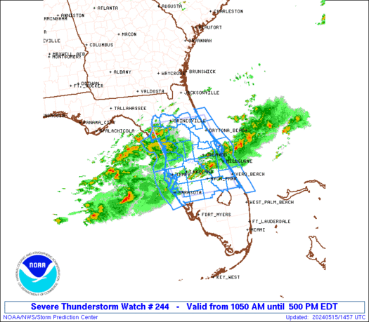
 URGENT - IMMEDIATE BROADCAST REQUESTED
Severe Thunderstorm Watch Number 244
NWS Storm Prediction Center Norman OK
1050 AM EDT Wed May 15 2024 The NWS Storm Prediction Center has issued a * Severe Thunderstorm Watch for portions of Northern/central Florida Peninsula Coastal Waters * Effective this Wednesday morning and afternoon from 1050 AM until 500 PM EDT. * Primary threats include... Scattered damaging wind gusts to 70 mph possible Scattered large hail events to 1.5 inches in diameter possible A tornado or two possible SUMMARY...Thunderstorms will spread eastward across parts of the
northern/central FL Peninsula through this afternoon, while posing a
threat for mainly large hail and damaging winds. The severe thunderstorm watch area is approximately along and 60
statute miles east and west of a line from 15 miles east of
Gainesville FL to 30 miles south of Avon Park FL. For a complete
depiction of the watch see the associated watch outline update
(WOUS64 KWNS WOU4). PRECAUTIONARY/PREPAREDNESS ACTIONS... REMEMBER...A Severe Thunderstorm Watch means conditions are
favorable for severe thunderstorms in and close to the watch area.
Persons in these areas should be on the lookout for threatening
weather conditions and listen for later statements and possible
warnings. Severe thunderstorms can and occasionally do produce
tornadoes. && OTHER WATCH INFORMATION...This severe thunderstorm watch replaces
tornado watch number 243. Watch number 243 will not be in effect
after 1050 AM EDT. AVIATION...A few severe thunderstorms with hail surface and aloft to
1.5 inches. Extreme turbulence and surface wind gusts to 60 knots. A
few cumulonimbi with maximum tops to 500. Mean storm motion vector
26035. ...Gleason
SPC Tornado Watch 243
WW 243 TORNADO FL CW 150645Z – 151500Z 
 URGENT - IMMEDIATE BROADCAST REQUESTED
Tornado Watch Number 243
NWS Storm Prediction Center Norman OK
245 AM EDT Wed May 15 2024 The NWS Storm Prediction Center has issued a * Tornado Watch for portions of Northern and Central Florida Coastal Waters * Effective this Wednesday morning from 245 AM until 1100 AM EDT. * Primary threats include... A couple tornadoes possible Isolated damaging wind gusts to 70 mph possible Isolated large hail events to 1.5 inches in diameter possible SUMMARY...At least isolated severe storms including supercells are
expected to develop through the predawn hours, especially across the
north-central Florida Peninsula. The severe risk/tornado potential
may further increase toward and beyond sunrise across broader
portions of the central Peninsula. The tornado watch area is approximately along and 70 statute miles
north and south of a line from 30 miles northwest of Saint
Petersburg FL to 20 miles east of Daytona Beach FL. For a complete
depiction of the watch see the associated watch outline update
(WOUS64 KWNS WOU3). PRECAUTIONARY/PREPAREDNESS ACTIONS... REMEMBER...A Tornado Watch means conditions are favorable for
tornadoes and severe thunderstorms in and close to the watch
area. Persons in these areas should be on the lookout for
threatening weather conditions and listen for later statements
and possible warnings. && AVIATION...Tornadoes and a few severe thunderstorms with hail
surface and aloft to 1.5 inches. Extreme turbulence and surface wind
gusts to 60 knots. A few cumulonimbi with maximum tops to 550. Mean
storm motion vector 25035. ...Guyer