SPC
SPC Severe Thunderstorm Watch 275
WW 275 SEVERE TSTM IA 211115Z – 211800Z 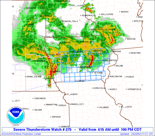
 URGENT - IMMEDIATE BROADCAST REQUESTED
Severe Thunderstorm Watch Number 275
NWS Storm Prediction Center Norman OK
615 AM CDT Tue May 21 2024 The NWS Storm Prediction Center has issued a * Severe Thunderstorm Watch for portions of Central and southern Iowa * Effective this Tuesday morning and afternoon from 615 AM until 100 PM CDT. * Primary threats include... Scattered damaging winds and isolated significant gusts to 75 mph possible Isolated large hail events to 1.5 inches in diameter possible A tornado or two possible SUMMARY...Clusters of thunderstorms -- including an organized bowing
complex initially over eastern NE -- will pose a threat mainly for
severe gusts while crossing the watch area from west to east. A
tornado or two cannot be ruled out, especially near an outflow
boundary draped across central/south-central IA. Isolated large
hail is possible. This is a precursor to the main severe-weather
threat expected later today, for which we have a "Moderate Risk"
outlook. The severe thunderstorm watch area is approximately along and 60
statute miles north and south of a line from 80 miles west of Des
Moines IA to 25 miles south southeast of Cedar Rapids IA. For a
complete depiction of the watch see the associated watch outline
update (WOUS64 KWNS WOU5). PRECAUTIONARY/PREPAREDNESS ACTIONS... REMEMBER...A Severe Thunderstorm Watch means conditions are
favorable for severe thunderstorms in and close to the watch area.
Persons in these areas should be on the lookout for threatening
weather conditions and listen for later statements and possible
warnings. Severe thunderstorms can and occasionally do produce
tornadoes. && OTHER WATCH INFORMATION...CONTINUE...WW 274... AVIATION...A few severe thunderstorms with hail surface and aloft to
1.5 inches. Extreme turbulence and surface wind gusts to 65 knots. A
few cumulonimbi with maximum tops to 550. Mean storm motion vector
26045. ...Edwards
SPC Severe Thunderstorm Watch 274
WW 274 SEVERE TSTM IA KS NE 210430Z – 211200Z 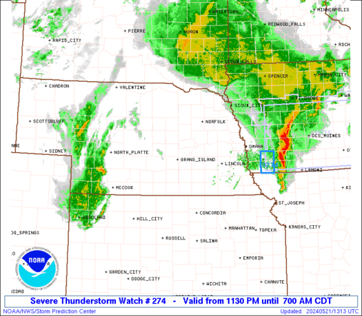
 URGENT - IMMEDIATE BROADCAST REQUESTED
Severe Thunderstorm Watch Number 274
NWS Storm Prediction Center Norman OK
1130 PM CDT Mon May 20 2024 The NWS Storm Prediction Center has issued a * Severe Thunderstorm Watch for portions of Extreme western Iowa Extreme north central Kansas Central into eastern Nebraska * Effective this Monday night and Tuesday morning from 1130 PM until 700 AM CDT. * Primary threats include... Widespread damaging winds and isolated significant gusts to 75 mph likely Scattered large hail events to 1.5 inches in diameter likely A tornado or two possible SUMMARY...Ongoing storms with a hail/wind threat may persist for a
couple more hours across eastern Nebraska/western Iowa, while storms
well to the west will grow upscale into a larger/bowing convective
system overnight into central then eastern Nebraska. Damaging wind
swaths up to 75 mph will be the main threat, along with large hail
up to 1.5 inches in diameter and a tornado or two with embedded
circulations. The severe thunderstorm watch area is approximately along and 65
statute miles north and south of a line from 60 miles south
southwest of Broken Bow NE to 20 miles northeast of Omaha NE. For a
complete depiction of the watch see the associated watch outline
update (WOUS64 KWNS WOU4). PRECAUTIONARY/PREPAREDNESS ACTIONS... REMEMBER...A Severe Thunderstorm Watch means conditions are
favorable for severe thunderstorms in and close to the watch area.
Persons in these areas should be on the lookout for threatening
weather conditions and listen for later statements and possible
warnings. Severe thunderstorms can and occasionally do produce
tornadoes. && OTHER WATCH INFORMATION...This severe thunderstorm watch replaces
severe thunderstorm watch number 271. Watch number 271 will not
be in effect after 1130 PM CDT. CONTINUE...WW 269...WW 272...WW
273... AVIATION...A few severe thunderstorms with hail surface and aloft to
1.5 inches. Extreme turbulence and surface wind gusts to 65 knots. A
few cumulonimbi with maximum tops to 500. Mean storm motion vector
25035. ...Thompson
SPC Tornado Watch 273
WW 273 TORNADO CO KS NE 210155Z – 210800Z 
 URGENT - IMMEDIATE BROADCAST REQUESTED
Tornado Watch Number 273
NWS Storm Prediction Center Norman OK
855 PM CDT Mon May 20 2024 The NWS Storm Prediction Center has issued a * Tornado Watch for portions of Extreme northeast Colorado Extreme northwest Kansas Southwest Nebraska * Effective this Monday night and Tuesday morning from 855 PM until 300 AM CDT. * Primary threats include... A few tornadoes likely with a couple intense tornadoes possible Scattered damaging winds and isolated significant gusts to 80 mph likely Scattered large hail and isolated very large hail events to 3 inches in diameter likely SUMMARY...Clusters of intensifying supercells across northeast
Colorado will continue eastward into Kansas/Nebraska with some
potential for upscale growth tonight. The storm environment will
favor all significant hazards of all types (tornadoes capable of EF2
damage, very large hail up to 3 inches in diameter, and severe
outflow winds up to 80 mph). The tornado watch area is approximately along and 55 statute miles
north and south of a line from 25 miles west of Imperial NE to 35
miles northeast of Mccook NE. For a complete depiction of the watch
see the associated watch outline update (WOUS64 KWNS WOU3). PRECAUTIONARY/PREPAREDNESS ACTIONS... REMEMBER...A Tornado Watch means conditions are favorable for
tornadoes and severe thunderstorms in and close to the watch
area. Persons in these areas should be on the lookout for
threatening weather conditions and listen for later statements
and possible warnings. && OTHER WATCH INFORMATION...CONTINUE...WW 268...WW 269...WW
270...WW 271...WW 272... AVIATION...Tornadoes and a few severe thunderstorms with hail
surface and aloft to 3 inches. Extreme turbulence and surface wind
gusts to 70 knots. A few cumulonimbi with maximum tops to 500. Mean
storm motion vector 27030. ...Thompson
SPC Severe Thunderstorm Watch 272
WW 272 SEVERE TSTM IA MN 202345Z – 210500Z 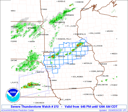
 URGENT - IMMEDIATE BROADCAST REQUESTED
Severe Thunderstorm Watch Number 272
NWS Storm Prediction Center Norman OK
645 PM CDT Mon May 20 2024 The NWS Storm Prediction Center has issued a * Severe Thunderstorm Watch for portions of Northwest and north central Iowa South central and southeast Minnesota * Effective this Monday night from 645 PM until Midnight CDT. * Primary threats include... Scattered damaging wind gusts to 60 mph possible Scattered large hail events to 1.5 inches in diameter possible SUMMARY...Scattered thunderstorm development is expected this
evening along a slow moving front across southern Minnesota and
northern Iowa. The storm environment will favor a mix of multicell
clusters and storms with supercell structure capable of producing
large hail of 1-1.5 inches in diameter and damaging outflow gusts up
to 60 mph. The severe thunderstorm watch area is approximately along and 45
statute miles north and south of a line from 35 miles east of
Rochester MN to 50 miles west of Storm Lake IA. For a complete
depiction of the watch see the associated watch outline update
(WOUS64 KWNS WOU2). PRECAUTIONARY/PREPAREDNESS ACTIONS... REMEMBER...A Severe Thunderstorm Watch means conditions are
favorable for severe thunderstorms in and close to the watch area.
Persons in these areas should be on the lookout for threatening
weather conditions and listen for later statements and possible
warnings. Severe thunderstorms can and occasionally do produce
tornadoes. && OTHER WATCH INFORMATION...CONTINUE...WW 268...WW 269...WW
270...WW 271... AVIATION...A few severe thunderstorms with hail surface and aloft to
1.5 inches. Extreme turbulence and surface wind gusts to 50 knots. A
few cumulonimbi with maximum tops to 500. Mean storm motion vector
27020. ...Thompson
SPC Severe Thunderstorm Watch 271
WW 271 SEVERE TSTM IA NE 202330Z – 210500Z 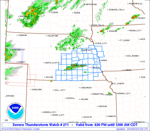
 URGENT - IMMEDIATE BROADCAST REQUESTED
Severe Thunderstorm Watch Number 271
NWS Storm Prediction Center Norman OK
630 PM CDT Mon May 20 2024 The NWS Storm Prediction Center has issued a * Severe Thunderstorm Watch for portions of Extreme west central Iowa South central into east central and southeast Nebraska * Effective this Monday night from 630 PM until Midnight CDT. * Primary threats include... Scattered large hail likely with isolated very large hail events to 2 inches in diameter possible Scattered damaging wind gusts to 70 mph possible SUMMARY...Scattered thunderstorms are expected to form this evening,
within an environment supporting supercells. Large hail of 1-2
inches in diameter and outflow gusts of 60-70 mph will be the main
threats through early tonight. The severe thunderstorm watch area is approximately along and 55
statute miles north and south of a line from 10 miles west northwest
of Kearney NE to 45 miles northeast of Lincoln NE. For a complete
depiction of the watch see the associated watch outline update
(WOUS64 KWNS WOU1). PRECAUTIONARY/PREPAREDNESS ACTIONS... REMEMBER...A Severe Thunderstorm Watch means conditions are
favorable for severe thunderstorms in and close to the watch area.
Persons in these areas should be on the lookout for threatening
weather conditions and listen for later statements and possible
warnings. Severe thunderstorms can and occasionally do produce
tornadoes. && OTHER WATCH INFORMATION...CONTINUE...WW 268...WW 269...WW 270... AVIATION...A few severe thunderstorms with hail surface and aloft to
2 inches. Extreme turbulence and surface wind gusts to 60 knots. A
few cumulonimbi with maximum tops to 500. Mean storm motion vector
24020. ...Thompson