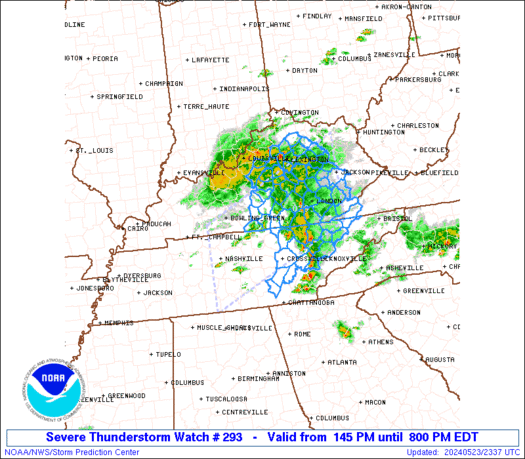
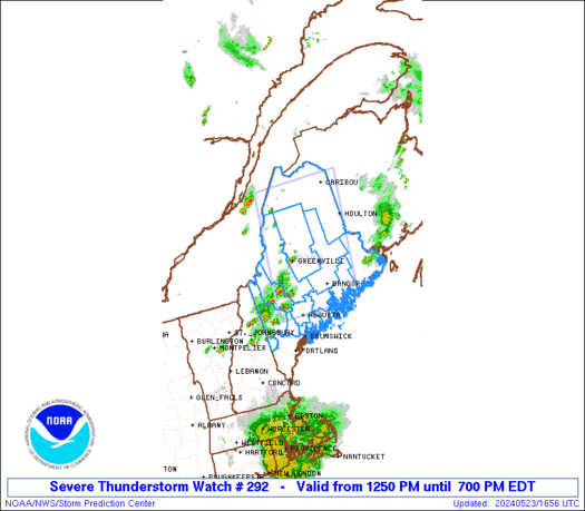
SPC Severe Thunderstorm Watch 294
WW 294 SEVERE TSTM ND NE SD 232025Z – 240400Z 
 URGENT - IMMEDIATE BROADCAST REQUESTED
Severe Thunderstorm Watch Number 294
NWS Storm Prediction Center Norman OK
325 PM CDT Thu May 23 2024 The NWS Storm Prediction Center has issued a * Severe Thunderstorm Watch for portions of Southeast North Dakota Central Nebraska Central and Eastern South Dakota * Effective this Thursday afternoon and evening from 325 PM until 1100 PM CDT. * Primary threats include... Scattered damaging wind gusts to 70 mph likely Scattered large hail and isolated very large hail events to 2.5 inches in diameter possible A tornado or two possible SUMMARY...Thunderstorms will increase in coverage through the
afternoon across the watch area. Very large hail and damaging winds
will be possible in the stronger cells. The severe thunderstorm watch area is approximately along and 55
statute miles east and west of a line from 60 miles north northeast
of Aberdeen SD to 40 miles southwest of North Platte NE. For a
complete depiction of the watch see the associated watch outline
update (WOUS64 KWNS WOU4). PRECAUTIONARY/PREPAREDNESS ACTIONS... REMEMBER...A Severe Thunderstorm Watch means conditions are
favorable for severe thunderstorms in and close to the watch area.
Persons in these areas should be on the lookout for threatening
weather conditions and listen for later statements and possible
warnings. Severe thunderstorms can and occasionally do produce
tornadoes. && OTHER WATCH INFORMATION...CONTINUE...WW 292...WW 293... AVIATION...A few severe thunderstorms with hail surface and aloft to
2.5 inches. Extreme turbulence and surface wind gusts to 60 knots. A
few cumulonimbi with maximum tops to 500. Mean storm motion vector
25030. ...Hart