SPC
SPC Severe Thunderstorm Watch 299
WW 299 SEVERE TSTM IA KS MO NE 240635Z – 241300Z 
 URGENT - IMMEDIATE BROADCAST REQUESTED
Severe Thunderstorm Watch Number 299
NWS Storm Prediction Center Norman OK
135 AM CDT Fri May 24 2024 The NWS Storm Prediction Center has issued a * Severe Thunderstorm Watch for portions of Southwestern Iowa Northeastern Kansas Northwestern Missouri Southeastern Nebraska * Effective this Friday morning from 135 AM until 800 AM CDT. * Primary threats include... Scattered damaging winds and isolated significant gusts to 80 mph possible Isolated large hail events to 1.5 inches in diameter possible A tornado or two possible SUMMARY...The southern part of a well-organized and sporadically
severe squall line should cross the watch area through the pre-dawn
hours. Severe-gust swaths and downbursts are the main concern, with
a brief/embedded tornado and/or isolated severe hail also possible. The severe thunderstorm watch area is approximately along and 50
statute miles east and west of a line from 55 miles south southwest
of Beatrice NE to 30 miles northeast of Shenandoah IA. For a
complete depiction of the watch see the associated watch outline
update (WOUS64 KWNS WOU9). PRECAUTIONARY/PREPAREDNESS ACTIONS... REMEMBER...A Severe Thunderstorm Watch means conditions are
favorable for severe thunderstorms in and close to the watch area.
Persons in these areas should be on the lookout for threatening
weather conditions and listen for later statements and possible
warnings. Severe thunderstorms can and occasionally do produce
tornadoes. && OTHER WATCH INFORMATION...CONTINUE...WW 297...WW 298... AVIATION...A few severe thunderstorms with hail surface and aloft to
1.5 inches. Extreme turbulence and surface wind gusts to 70 knots. A
few cumulonimbi with maximum tops to 550. Mean storm motion vector
27040. ...Edwards
SPC Severe Thunderstorm Watch 298
WW 298 SEVERE TSTM AR OK TX 240340Z – 241000Z 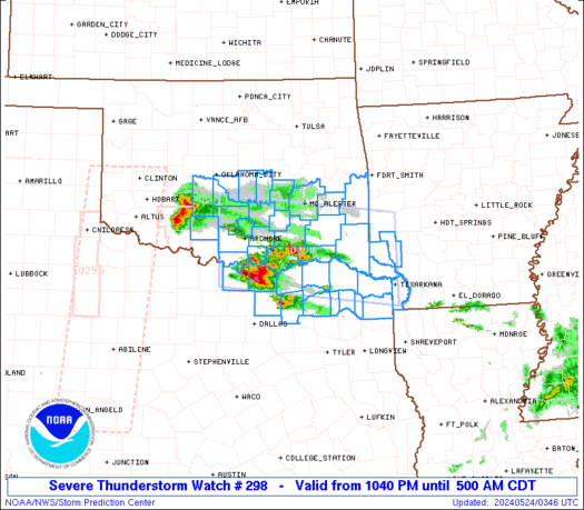
 URGENT - IMMEDIATE BROADCAST REQUESTED
Severe Thunderstorm Watch Number 298
NWS Storm Prediction Center Norman OK
1040 PM CDT Thu May 23 2024 The NWS Storm Prediction Center has issued a * Severe Thunderstorm Watch for portions of Extreme southwest Arkansas South central and southeast Oklahoma Northeast Texas * Effective this Thursday night and Friday morning from 1040 PM until 500 AM CDT. * Primary threats include... Scattered large hail and isolated very large hail events to 2 inches in diameter possible Isolated damaging wind gusts to 70 mph possible SUMMARY...Slightly elevated storms will continue to increase through
the overnight hours and spread eastward near the Red River, with the
potential for both supercells with large hail up to 2 inches in
diameter, and some upscale growth into a small cluster with 60-70
mph outflow gusts. The severe thunderstorm watch area is approximately along and 55
statute miles north and south of a line from 30 miles west of
Ardmore OK to 30 miles east southeast of De Queen AR. For a complete
depiction of the watch see the associated watch outline update
(WOUS64 KWNS WOU8). PRECAUTIONARY/PREPAREDNESS ACTIONS... REMEMBER...A Severe Thunderstorm Watch means conditions are
favorable for severe thunderstorms in and close to the watch area.
Persons in these areas should be on the lookout for threatening
weather conditions and listen for later statements and possible
warnings. Severe thunderstorms can and occasionally do produce
tornadoes. && OTHER WATCH INFORMATION...CONTINUE...WW 294...WW 295...WW 297... AVIATION...A few severe thunderstorms with hail surface and aloft to
2 inches. Extreme turbulence and surface wind gusts to 60 knots. A
few cumulonimbi with maximum tops to 550. Mean storm motion vector
27025. ...Thompson
SPC Severe Thunderstorm Watch 297
WW 297 SEVERE TSTM IA KS NE SD 240145Z – 240900Z 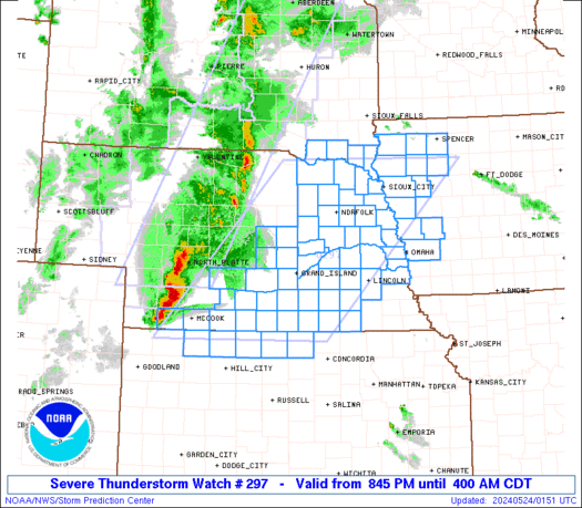
 URGENT - IMMEDIATE BROADCAST REQUESTED
Severe Thunderstorm Watch Number 297
NWS Storm Prediction Center Norman OK
845 PM CDT Thu May 23 2024 The NWS Storm Prediction Center has issued a * Severe Thunderstorm Watch for portions of Western Iowa Extreme northern Kansas Central and eastern Nebraska Extreme southeast South Dakota * Effective this Thursday night and Friday morning from 845 PM until 400 AM CDT. * Primary threats include... Widespread damaging winds and isolated significant gusts to 85 mph likely Scattered large hail and isolated very large hail events to 2.5 inches in diameter possible A tornado or two possible SUMMARY...An intense storm cluster with embedded supercells in
central Nebraska is expected to grow upscale into a larger bowing
line overnight, with an accompanying threat for swaths of severe
wind (60-85 mph). The initial supercells could produce isolated
very large hail up to 2-2.5 inches in diameter, and a tornado or two
will be possible with embedded circulations. The severe thunderstorm watch area is approximately along and 100
statute miles east and west of a line from 35 miles north northwest
of Sioux City IA to 60 miles east southeast of Mccook NE. For a
complete depiction of the watch see the associated watch outline
update (WOUS64 KWNS WOU7). PRECAUTIONARY/PREPAREDNESS ACTIONS... REMEMBER...A Severe Thunderstorm Watch means conditions are
favorable for severe thunderstorms in and close to the watch area.
Persons in these areas should be on the lookout for threatening
weather conditions and listen for later statements and possible
warnings. Severe thunderstorms can and occasionally do produce
tornadoes. && OTHER WATCH INFORMATION...CONTINUE...WW 294...WW 295...WW 296... AVIATION...A few severe thunderstorms with hail surface and aloft to
2.5 inches. Extreme turbulence and surface wind gusts to 75 knots. A
few cumulonimbi with maximum tops to 550. Mean storm motion vector
25040. ...Thompson
SPC Tornado Watch 296
WW 296 TORNADO TX 232255Z – 240400Z 
 URGENT - IMMEDIATE BROADCAST REQUESTED
Tornado Watch Number 296
NWS Storm Prediction Center Norman OK
555 PM CDT Thu May 23 2024 The NWS Storm Prediction Center has issued a * Tornado Watch for portions of Central Texas * Effective this Thursday afternoon and evening from 555 PM until 1100 PM CDT. * Primary threats include... A couple tornadoes possible Scattered large hail and isolated very large hail events to 2.5 inches in diameter possible Isolated damaging wind gusts to 70 mph possible SUMMARY...An isolated supercell or two will pose a threat for a
couple of tornadoes, isolated very large hail up to 2.5 inches in
diameter and isolated damaging gusts of 60-70 mph for the next few
hours. The tornado watch area is approximately along and 30 statute miles
north and south of a line from 15 miles south of Temple TX to 125
miles east northeast of Temple TX. For a complete depiction of the
watch see the associated watch outline update (WOUS64 KWNS WOU6). PRECAUTIONARY/PREPAREDNESS ACTIONS... REMEMBER...A Tornado Watch means conditions are favorable for
tornadoes and severe thunderstorms in and close to the watch
area. Persons in these areas should be on the lookout for
threatening weather conditions and listen for later statements
and possible warnings. && OTHER WATCH INFORMATION...CONTINUE...WW 293...WW 294...WW 295... AVIATION...Tornadoes and a few severe thunderstorms with hail
surface and aloft to 2.5 inches. Extreme turbulence and surface wind
gusts to 60 knots. A few cumulonimbi with maximum tops to 600. Mean
storm motion vector 27020. ...Thompson
SPC Tornado Watch 295
WW 295 TORNADO OK TX 232130Z – 240400Z 
 URGENT - IMMEDIATE BROADCAST REQUESTED
Tornado Watch Number 295
NWS Storm Prediction Center Norman OK
430 PM CDT Thu May 23 2024 The NWS Storm Prediction Center has issued a * Tornado Watch for portions of Southwest Oklahoma The Edwards Plateau into northwest Texas * Effective this Thursday afternoon and evening from 430 PM until 1100 PM CDT. * Primary threats include... A couple tornadoes possible Scattered large hail and isolated very large hail events to 3.5 inches in diameter possible Isolated damaging wind gusts to 70 mph possible SUMMARY...A few supercells are expected to form late this afternoon
along the dryline, and storms will move slowly eastward through late
evening. The storm environment favors isolated very large hail (up
to 3.5 inches in diameter) as the main threat, though a couple of
tornadoes will also be possible. The tornado watch area is approximately along and 45 statute miles
east and west of a line from 20 miles northwest of Clinton OK to 35
miles southeast of San Angelo TX. For a complete depiction of the
watch see the associated watch outline update (WOUS64 KWNS WOU5). PRECAUTIONARY/PREPAREDNESS ACTIONS... REMEMBER...A Tornado Watch means conditions are favorable for
tornadoes and severe thunderstorms in and close to the watch
area. Persons in these areas should be on the lookout for
threatening weather conditions and listen for later statements
and possible warnings. && OTHER WATCH INFORMATION...CONTINUE...WW 293...WW 294... AVIATION...Tornadoes and a few severe thunderstorms with hail
surface and aloft to 3.5 inches. Extreme turbulence and surface wind
gusts to 60 knots. A few cumulonimbi with maximum tops to 600. Mean
storm motion vector 26020. ...Thompson