SPC
SPC Tornado Watch 319
WW 319 TORNADO AR KS MO OK 262025Z – 270200Z 
 URGENT - IMMEDIATE BROADCAST REQUESTED
Tornado Watch Number 319
NWS Storm Prediction Center Norman OK
325 PM CDT Sun May 26 2024 The NWS Storm Prediction Center has issued a * Tornado Watch for portions of Extreme Northwest Arkansas Southeast Kansas Southwest Missouri Extreme Northeast Oklahoma * Effective this Sunday afternoon and evening from 325 PM until 900 PM CDT. * Primary threats include... A couple tornadoes possible Scattered large hail and isolated very large hail events to 2.5 inches in diameter likely Scattered damaging wind gusts to 70 mph likely SUMMARY...Isolated supercell thunderstorms will continue to develop
through the remainder of the afternoon and into early evening. Very
large hail, up to 2.5 inches in diameter, will be possible, along
with the risk for a couple of tornadoes. The tornado watch area is approximately along and 60 statute miles
north and south of a line from 20 miles west of Joplin MO to 50
miles east northeast of Springfield MO. For a complete depiction of
the watch see the associated watch outline update (WOUS64 KWNS
WOU9). PRECAUTIONARY/PREPAREDNESS ACTIONS... REMEMBER...A Tornado Watch means conditions are favorable for
tornadoes and severe thunderstorms in and close to the watch
area. Persons in these areas should be on the lookout for
threatening weather conditions and listen for later statements
and possible warnings. && OTHER WATCH INFORMATION...CONTINUE...WW 316...WW 317...WW 318... AVIATION...Tornadoes and a few severe thunderstorms with hail
surface and aloft to 2.5 inches. Extreme turbulence and surface wind
gusts to 60 knots. A few cumulonimbi with maximum tops to 600. Mean
storm motion vector 27030. ...Bunting
SPC Severe Thunderstorm Watch 318
WW 318 SEVERE TSTM OH PA WV LE 261945Z – 270200Z 
 URGENT - IMMEDIATE BROADCAST REQUESTED
Severe Thunderstorm Watch Number 318
NWS Storm Prediction Center Norman OK
345 PM EDT Sun May 26 2024 The NWS Storm Prediction Center has issued a * Severe Thunderstorm Watch for portions of Northeast Ohio Western Pennsylvania Northern West Virginia Lake Erie * Effective this Sunday afternoon and evening from 345 PM until 1000 PM EDT. * Primary threats include... Scattered damaging wind gusts to 70 mph possible Isolated large hail events to 1.5 inches in diameter possible A tornado or two possible SUMMARY...A line of severe thunderstorms will continue to move
northeast through early this evening, posing a risk for damaging
wind gusts and possibly a couple tornadoes. The severe thunderstorm watch area is approximately along and 60
statute miles north and south of a line from 30 miles west southwest
of Akron OH to 30 miles north of Latrobe PA. For a complete
depiction of the watch see the associated watch outline update
(WOUS64 KWNS WOU8). PRECAUTIONARY/PREPAREDNESS ACTIONS... REMEMBER...A Severe Thunderstorm Watch means conditions are
favorable for severe thunderstorms in and close to the watch area.
Persons in these areas should be on the lookout for threatening
weather conditions and listen for later statements and possible
warnings. Severe thunderstorms can and occasionally do produce
tornadoes. && OTHER WATCH INFORMATION...CONTINUE...WW 315...WW 316...WW 317... AVIATION...A few severe thunderstorms with hail surface and aloft to
1.5 inches. Extreme turbulence and surface wind gusts to 60 knots. A
few cumulonimbi with maximum tops to 500. Mean storm motion vector
24035. ...Bunting
SPC Severe Thunderstorm Watch 317
WW 317 SEVERE TSTM KY NC OH TN VA WV 261745Z – 270100Z 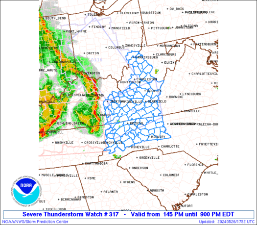
 URGENT - IMMEDIATE BROADCAST REQUESTED
Severe Thunderstorm Watch Number 317
NWS Storm Prediction Center Norman OK
145 PM EDT Sun May 26 2024 The NWS Storm Prediction Center has issued a * Severe Thunderstorm Watch for portions of Eastern Kentucky Western North Carolina Southeast Ohio Eastern Tennessee Southwest Virginia Central and Southern West Virginia * Effective this Sunday afternoon and evening from 145 PM until 900 PM EDT. * Primary threats include... Scattered damaging wind gusts to 70 mph likely Isolated large hail events to 1.5 inches in diameter possible A tornado or two possible SUMMARY...A bowing complex of severe thunderstorms will continue
moving east through the remainder of this afternoon and early
evening. Damaging thunderstorm wind gusts and a tornado or two will
be the primary severe weather hazards, however isolated large hail
will also be possible. The severe thunderstorm watch area is approximately along and 60
statute miles north and south of a line from 55 miles west northwest
of Bristol TN to 20 miles northeast of Dublin VA. For a complete
depiction of the watch see the associated watch outline update
(WOUS64 KWNS WOU7). PRECAUTIONARY/PREPAREDNESS ACTIONS... REMEMBER...A Severe Thunderstorm Watch means conditions are
favorable for severe thunderstorms in and close to the watch area.
Persons in these areas should be on the lookout for threatening
weather conditions and listen for later statements and possible
warnings. Severe thunderstorms can and occasionally do produce
tornadoes. && OTHER WATCH INFORMATION...CONTINUE...WW 315...WW 316... AVIATION...A few severe thunderstorms with hail surface and aloft to
1.5 inches. Extreme turbulence and surface wind gusts to 60 knots. A
few cumulonimbi with maximum tops to 500. Mean storm motion vector
25040. ...Bunting
SPC Severe Thunderstorm Watch 316
WW 316 SEVERE TSTM IN KY OH WV 261700Z – 270000Z 
 URGENT - IMMEDIATE BROADCAST REQUESTED
Severe Thunderstorm Watch Number 316
NWS Storm Prediction Center Norman OK
100 PM EDT Sun May 26 2024 The NWS Storm Prediction Center has issued a * Severe Thunderstorm Watch for portions of Eastern Indiana Northeast Kentucky Western and Central Ohio Western West Virginia * Effective this Sunday afternoon and evening from 100 PM until 800 PM EDT. * Primary threats include... Scattered damaging wind gusts to 70 mph likely Scattered large hail events to 1.5 inches in diameter possible A tornado or two possible SUMMARY...A bowing complex of severe thunderstorms will continue
moving rapidly northeast posing a risk for damaging wind gusts, and
a tornado or two. Isolated instances of large hail will also be
possible. The severe thunderstorm watch area is approximately along and 60
statute miles either side of a line from 70 miles north of Dayton OH
to 30 miles south southeast of Huntington WV. For a complete
depiction of the watch see the associated watch outline update
(WOUS64 KWNS WOU6). PRECAUTIONARY/PREPAREDNESS ACTIONS... REMEMBER...A Severe Thunderstorm Watch means conditions are
favorable for severe thunderstorms in and close to the watch area.
Persons in these areas should be on the lookout for threatening
weather conditions and listen for later statements and possible
warnings. Severe thunderstorms can and occasionally do produce
tornadoes. && OTHER WATCH INFORMATION...CONTINUE...WW 315... AVIATION...A few severe thunderstorms with hail surface and aloft to
1.5 inches. Extreme turbulence and surface wind gusts to 60 knots. A
few cumulonimbi with maximum tops to 500. Mean storm motion vector
24045. ...Bunting
SPC Tornado Watch 315
WW 315 TORNADO IN KY TN 261355Z – 262000Z 
 URGENT - IMMEDIATE BROADCAST REQUESTED
Tornado Watch Number 315
NWS Storm Prediction Center Norman OK
855 AM CDT Sun May 26 2024 The NWS Storm Prediction Center has issued a * Tornado Watch for portions of Southern Indiana Western and Central Kentucky Western and Middle Tennessee * Effective this Sunday morning and afternoon from 855 AM until 300 PM CDT. * Primary threats include... A few tornadoes likely with a couple intense tornadoes possible Widespread damaging winds and isolated significant gusts to 75 mph likely Scattered large hail and isolated very large hail events to 2 inches in diameter likely SUMMARY...A bowing complex of severe thunderstorms will continue
moving rapidly east, with widespread damaging winds likely. Some
gusts may exceed 75 mph. A few tornadoes are also possible. The tornado watch area is approximately along and 80 statute miles
north and south of a line from 10 miles northwest of Fort Campbell
KY to 40 miles south southeast of London KY. For a complete
depiction of the watch see the associated watch outline update
(WOUS64 KWNS WOU5). PRECAUTIONARY/PREPAREDNESS ACTIONS... REMEMBER...A Tornado Watch means conditions are favorable for
tornadoes and severe thunderstorms in and close to the watch
area. Persons in these areas should be on the lookout for
threatening weather conditions and listen for later statements
and possible warnings. && OTHER WATCH INFORMATION...CONTINUE...WW 314... AVIATION...Tornadoes and a few severe thunderstorms with hail
surface and aloft to 2 inches. Extreme turbulence and surface wind
gusts to 65 knots. A few cumulonimbi with maximum tops to 500. Mean
storm motion vector 27045. ...Bunting