SPC
SPC Severe Thunderstorm Watch 169
WW 169 SEVERE TSTM CO 242140Z – 250400Z 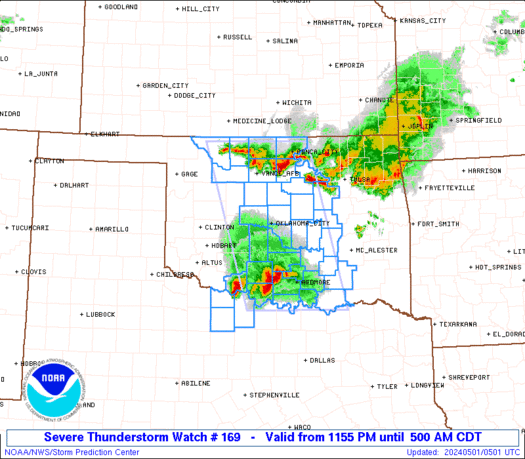
 URGENT - IMMEDIATE BROADCAST REQUESTED
Severe Thunderstorm Watch Number 169
NWS Storm Prediction Center Norman OK
440 PM CDT Thu Apr 24 2025 The NWS Storm Prediction Center has issued a * Severe Thunderstorm Watch for portions of Eastern Colorado * Effective this Thursday afternoon and evening from 440 PM until 1100 PM CDT. * Primary threats include... Scattered large hail likely with isolated very large hail events to 2 inches in diameter possible Isolated damaging wind gusts to 70 mph possible A tornado or two possible SUMMARY...Additional strong/severe storm development is expected to
occur through late afternoon, especially across
east-central/southeast Colorado. This will include a combo of
multicells and a few supercells with large hail expected to be the
most probable severe hazard. The severe thunderstorm watch area is approximately along and 85
statute miles north and south of a line from 10 miles west northwest
of Pueblo CO to 35 miles east of Lamar CO. For a complete depiction
of the watch see the associated watch outline update (WOUS64 KWNS
WOU9). PRECAUTIONARY/PREPAREDNESS ACTIONS... REMEMBER...A Severe Thunderstorm Watch means conditions are
favorable for severe thunderstorms in and close to the watch area.
Persons in these areas should be on the lookout for threatening
weather conditions and listen for later statements and possible
warnings. Severe thunderstorms can and occasionally do produce
tornadoes. && OTHER WATCH INFORMATION...CONTINUE...WW 166...WW 167...WW 168... AVIATION...A few severe thunderstorms with hail surface and aloft to
2 inches. Extreme turbulence and surface wind gusts to 60 knots. A
few cumulonimbi with maximum tops to 500. Mean storm motion vector
29025. ...Guyer
SPC Severe Thunderstorm Watch 168
WW 168 SEVERE TSTM NM TX 242100Z – 250300Z 
 URGENT - IMMEDIATE BROADCAST REQUESTED
Severe Thunderstorm Watch Number 168
NWS Storm Prediction Center Norman OK
400 PM CDT Thu Apr 24 2025 The NWS Storm Prediction Center has issued a * Severe Thunderstorm Watch for portions of Far Southeast New Mexico West Texas * Effective this Thursday afternoon and evening from 400 PM until 1000 PM CDT. * Primary threats include... Scattered large hail and isolated very large hail events to 3 inches in diameter possible Scattered damaging wind gusts to 70 mph possible SUMMARY...Isolated thunderstorms are forecast to develop through the
late afternoon and early evening. The stronger storms will likely
become supercellular and pose mainly a threat for large to very
large hail. The severe thunderstorm watch area is approximately along and 70
statute miles east and west of a line from 65 miles north northwest
of Big Spring TX to 25 miles west southwest of Dryden TX. For a
complete depiction of the watch see the associated watch outline
update (WOUS64 KWNS WOU8). PRECAUTIONARY/PREPAREDNESS ACTIONS... REMEMBER...A Severe Thunderstorm Watch means conditions are
favorable for severe thunderstorms in and close to the watch area.
Persons in these areas should be on the lookout for threatening
weather conditions and listen for later statements and possible
warnings. Severe thunderstorms can and occasionally do produce
tornadoes. && OTHER WATCH INFORMATION...CONTINUE...WW 166...WW 167... AVIATION...A few severe thunderstorms with hail surface and aloft to
3 inches. Extreme turbulence and surface wind gusts to 60 knots. A
few cumulonimbi with maximum tops to 500. Mean storm motion vector
31015. ...Smith
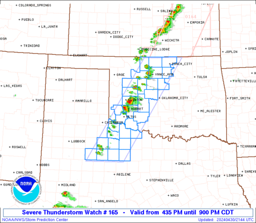
SPC Tornado Watch 167
WW 167 TORNADO OK TX 242035Z – 250400Z 
 URGENT - IMMEDIATE BROADCAST REQUESTED
Tornado Watch Number 167
NWS Storm Prediction Center Norman OK
335 PM CDT Thu Apr 24 2025 The NWS Storm Prediction Center has issued a * Tornado Watch for portions of Oklahoma Panhandle Texas Panhandle and South Plains * Effective this Thursday afternoon and evening from 335 PM until 1100 PM CDT. * Primary threats include... A couple tornadoes possible Scattered large hail and isolated very large hail events to 4 inches in diameter likely Isolated damaging wind gusts to 70 mph possible SUMMARY...Widely scattered thunderstorms are forecast to rapidly
develop this afternoon into the early evening. Environmental shear
and buoyancy combinations strongly favor intense, discrete
supercells. Large to giant hail will be probable with any
supercell. The tornado risk will likely focus for a few hours
during the early evening near a residual outflow boundary draped
over parts of the Watch area. The tornado watch area is approximately along and 60 statute miles
east and west of a line from 30 miles northeast of Guymon OK to 60
miles southeast of Lubbock TX. For a complete depiction of the watch
see the associated watch outline update (WOUS64 KWNS WOU7). PRECAUTIONARY/PREPAREDNESS ACTIONS... REMEMBER...A Tornado Watch means conditions are favorable for
tornadoes and severe thunderstorms in and close to the watch
area. Persons in these areas should be on the lookout for
threatening weather conditions and listen for later statements
and possible warnings. && OTHER WATCH INFORMATION...CONTINUE...WW 166... AVIATION...Tornadoes and a few severe thunderstorms with hail
surface and aloft to 4 inches. Extreme turbulence and surface wind
gusts to 60 knots. A few cumulonimbi with maximum tops to 550. Mean
storm motion vector 29015. ...Smith
SPC Severe Thunderstorm Watch 166
WW 166 SEVERE TSTM TX 241955Z – 250100Z 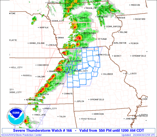
 URGENT - IMMEDIATE BROADCAST REQUESTED
Severe Thunderstorm Watch Number 166
NWS Storm Prediction Center Norman OK
255 PM CDT Thu Apr 24 2025 The NWS Storm Prediction Center has issued a * Severe Thunderstorm Watch for portions of Central into East Texas * Effective this Thursday afternoon and evening from 255 PM until 800 PM CDT. * Primary threats include... Scattered damaging wind gusts to 70 mph possible Isolated large hail events to 1.5 inches in diameter possible SUMMARY...A linear cluster of strong to severe thunderstorms will
likely continue east across much of the Watch area this afternoon
into the early evening. Severe gusts 60-70 mph appear to be the
primary hazard, but large hail may accompany the stronger cells on
the southwestern flank of the thunderstorm band. The severe thunderstorm watch area is approximately along and 50
statute miles north and south of a line from 35 miles west of Temple
TX to 25 miles east of Lufkin TX. For a complete depiction of the
watch see the associated watch outline update (WOUS64 KWNS WOU6). PRECAUTIONARY/PREPAREDNESS ACTIONS... REMEMBER...A Severe Thunderstorm Watch means conditions are
favorable for severe thunderstorms in and close to the watch area.
Persons in these areas should be on the lookout for threatening
weather conditions and listen for later statements and possible
warnings. Severe thunderstorms can and occasionally do produce
tornadoes. && AVIATION...A few severe thunderstorms with hail surface and aloft to
1.5 inches. Extreme turbulence and surface wind gusts to 60 knots. A
few cumulonimbi with maximum tops to 500. Mean storm motion vector
28030. ...Smith
SPC – No watches are valid as of Thu Apr 24 10:02:02 UTC 2025
No watches are valid as of Thu Apr 24 10:02:02 UTC 2025.