SPC
SPC Severe Thunderstorm Watch 324
WW 324 SEVERE TSTM AL GA TN 252025Z – 260400Z 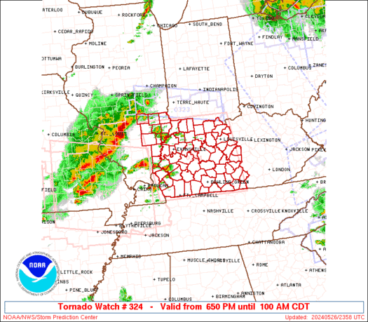
 URGENT - IMMEDIATE BROADCAST REQUESTED
Severe Thunderstorm Watch Number 324
NWS Storm Prediction Center Norman OK
325 PM CDT Sun May 25 2025 The NWS Storm Prediction Center has issued a * Severe Thunderstorm Watch for portions of Northern Alabama Northwest Georgia Southern Middle Tennessee * Effective this Sunday afternoon and evening from 325 PM until 1100 PM CDT. * Primary threats include... Scattered damaging wind gusts to 70 mph possible Isolated large hail events to 1 inch in diameter possible A tornado or two possible SUMMARY...A line of storms will move southeastward this afternoon
and pose mainly a damaging wind risk. Additional storms, perhaps as
a well-organized line, are expected to move into the region,
particularly northern Alabama, by evening, posing an additional
round of severe storms. The severe thunderstorm watch area is approximately along and 45
statute miles north and south of a line from 25 miles west southwest
of Muscle Shoals AL to 20 miles south southeast of Chattanooga TN.
For a complete depiction of the watch see the associated watch
outline update (WOUS64 KWNS WOU4). PRECAUTIONARY/PREPAREDNESS ACTIONS... REMEMBER...A Severe Thunderstorm Watch means conditions are
favorable for severe thunderstorms in and close to the watch area.
Persons in these areas should be on the lookout for threatening
weather conditions and listen for later statements and possible
warnings. Severe thunderstorms can and occasionally do produce
tornadoes. && OTHER WATCH INFORMATION...CONTINUE...WW 322...WW 323... AVIATION...A few severe thunderstorms with hail surface and aloft to
1 inch. Extreme turbulence and surface wind gusts to 60 knots. A few
cumulonimbi with maximum tops to 550. Mean storm motion vector
29045. ...Guyer
SPC – No watches are valid as of Sun May 25 14:02:02 UTC 2025
No watches are valid as of Sun May 25 14:02:02 UTC 2025.
SPC Severe Thunderstorm Watch 320
WW 320 SEVERE TSTM CO KS 250240Z – 251000Z 
 URGENT - IMMEDIATE BROADCAST REQUESTED
Severe Thunderstorm Watch Number 320
NWS Storm Prediction Center Norman OK
840 PM MDT Sat May 24 2025 The NWS Storm Prediction Center has issued a * Severe Thunderstorm Watch for portions of East-Central Colorado Northwest Kansas * Effective this Saturday night and Sunday morning from 840 PM until 400 AM MDT. * Primary threats include... Scattered large hail and isolated very large hail events to 2 inches in diameter possible Scattered damaging wind gusts to 70 mph possible SUMMARY...Thunderstorm cluster over the Colorado Front Range
vicinity has trended more linear and increased its eastward
progression over the past hour or so. Continued eastward motion
should take this storm into more of east-central Colorado and
eventually northwestern Kansas tonight. Environmental conditions in
this region will supporting a continuing threat for large hail and
damaging gusts. The severe thunderstorm watch area is approximately along and 45
statute miles north and south of a line from 70 miles west southwest
of Burlington CO to 45 miles southeast of Goodland KS. For a
complete depiction of the watch see the associated watch outline
update (WOUS64 KWNS WOU0). PRECAUTIONARY/PREPAREDNESS ACTIONS... REMEMBER...A Severe Thunderstorm Watch means conditions are
favorable for severe thunderstorms in and close to the watch area.
Persons in these areas should be on the lookout for threatening
weather conditions and listen for later statements and possible
warnings. Severe thunderstorms can and occasionally do produce
tornadoes. && OTHER WATCH INFORMATION...CONTINUE...WW 319... AVIATION...A few severe thunderstorms with hail surface and aloft to
2 inches. Extreme turbulence and surface wind gusts to 60 knots. A
few cumulonimbi with maximum tops to 500. Mean storm motion vector
24035. ...Mosier
SPC Severe Thunderstorm Watch 315
WW 315 SEVERE TSTM AR OK 240730Z – 241500Z 
 URGENT - IMMEDIATE BROADCAST REQUESTED
Severe Thunderstorm Watch Number 315
NWS Storm Prediction Center Norman OK
230 AM CDT Sat May 24 2025 The NWS Storm Prediction Center has issued a * Severe Thunderstorm Watch for portions of Far Western Arkansas Central and Eastern Oklahoma * Effective this Saturday morning from 230 AM until 1000 AM CDT. * Primary threats include... Scattered damaging wind gusts to 70 mph possible Isolated very large hail events to 2 inches in diameter possible SUMMARY...Mainly elevated supercells should continue to pose a
threat for isolated severe hail this morning. A cluster of
thunderstorms in south-central Kansas should spread southeastward
across parts of central and eastern OK over the next several hours.
This activity may pose some threat for scattered severe/damaging
winds, with peak gusts potentially reaching up to 60-70 mph. The severe thunderstorm watch area is approximately along and 115
statute miles east and west of a line from 20 miles northeast of
Ponca City OK to 30 miles south southwest of Mcalester OK. For a
complete depiction of the watch see the associated watch outline
update (WOUS64 KWNS WOU5). PRECAUTIONARY/PREPAREDNESS ACTIONS... REMEMBER...A Severe Thunderstorm Watch means conditions are
favorable for severe thunderstorms in and close to the watch area.
Persons in these areas should be on the lookout for threatening
weather conditions and listen for later statements and possible
warnings. Severe thunderstorms can and occasionally do produce
tornadoes. && OTHER WATCH INFORMATION...CONTINUE...WW 314... AVIATION...A few severe thunderstorms with hail surface and aloft to
2 inches. Extreme turbulence and surface wind gusts to 60 knots. A
few cumulonimbi with maximum tops to 500. Mean storm motion vector
31035. ...Gleason
SPC Severe Thunderstorm Watch 314
WW 314 SEVERE TSTM KS 240335Z – 241100Z 
 URGENT - IMMEDIATE BROADCAST REQUESTED
Severe Thunderstorm Watch Number 314
NWS Storm Prediction Center Norman OK
1035 PM CDT Fri May 23 2025 The NWS Storm Prediction Center has issued a * Severe Thunderstorm Watch for portions of Central and Southern Kansas * Effective this Friday night and Saturday morning from 1035 PM until 600 AM CDT. * Primary threats include... Scattered large hail and isolated very large hail events to 2 inches in diameter likely Scattered damaging winds likely with isolated significant gusts to 80 mph possible SUMMARY...Thunderstorm coverage is expected to increase tonight
across central and southern Kansas. Large to very large hail is
possible initially. Storms are expected to grow upscale over time,
and this transition towards a more linear mode will favor an
increased potential for damaging gusts. The severe thunderstorm watch area is approximately along and 50
statute miles north and south of a line from 10 miles north
northwest of Garden City KS to 60 miles east of Wichita KS. For a
complete depiction of the watch see the associated watch outline
update (WOUS64 KWNS WOU4). PRECAUTIONARY/PREPAREDNESS ACTIONS... REMEMBER...A Severe Thunderstorm Watch means conditions are
favorable for severe thunderstorms in and close to the watch area.
Persons in these areas should be on the lookout for threatening
weather conditions and listen for later statements and possible
warnings. Severe thunderstorms can and occasionally do produce
tornadoes. && AVIATION...A few severe thunderstorms with hail surface and aloft to
2 inches. Extreme turbulence and surface wind gusts to 70 knots. A
few cumulonimbi with maximum tops to 500. Mean storm motion vector
27035. ...Mosier
SPC – No watches are valid as of Fri May 23 06:02:02 UTC 2025
No watches are valid as of Fri May 23 06:02:02 UTC 2025.