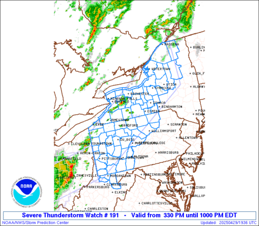
SPC Severe Thunderstorm Watch 63

WW 63 SEVERE TSTM AR LA TX 232320Z – 240600Z
WW 0063 Image

 URGENT - IMMEDIATE BROADCAST REQUESTED
Severe Thunderstorm Watch Number 63
NWS Storm Prediction Center Norman OK
620 PM CDT Sun Mar 23 2025 The NWS Storm Prediction Center has issued a * Severe Thunderstorm Watch for portions of Southen and East-Central Arkansas Northern Louisiana East Texas * Effective this Sunday night and Monday morning from 620 PM until 100 AM CDT. * Primary threats include... Scattered large hail likely with isolated very large hail events to 2.5 inches in diameter possible Scattered damaging wind gusts to 70 mph possible A tornado or two possible SUMMARY...Thunderstorms will continue to develop along and ahead of
a cold front this evening. Supercells will be capable of producing
scattered large hail, with the largest stones potentially reaching
up to 1.5-2.5 inches in diameter. Damaging winds may also occur with
any clusters that form later this evening. The severe thunderstorm watch area is approximately along and 70
statute miles north and south of a line from 20 miles north
northeast of Monroe LA to 40 miles south southwest of Longview TX.
For a complete depiction of the watch see the associated watch
outline update (WOUS64 KWNS WOU3). PRECAUTIONARY/PREPAREDNESS ACTIONS... REMEMBER...A Severe Thunderstorm Watch means conditions are
favorable for severe thunderstorms in and close to the watch area.
Persons in these areas should be on the lookout for threatening
weather conditions and listen for later statements and possible
warnings. Severe thunderstorms can and occasionally do produce
tornadoes. && OTHER WATCH INFORMATION...CONTINUE...WW 60...WW 61...WW 62... AVIATION...A few severe thunderstorms with hail surface and aloft to
2.5 inches. Extreme turbulence and surface wind gusts to 60 knots. A
few cumulonimbi with maximum tops to 500. Mean storm motion vector
26030. ...Gleason 

Read more

SPC Severe Thunderstorm Watch 62

WW 62 SEVERE TSTM TX 232250Z – 240600Z
WW 0062 Image

 URGENT - IMMEDIATE BROADCAST REQUESTED
Severe Thunderstorm Watch Number 62
NWS Storm Prediction Center Norman OK
550 PM CDT Sun Mar 23 2025 The NWS Storm Prediction Center has issued a * Severe Thunderstorm Watch for portions of Central Texas * Effective this Sunday afternoon and Monday morning from 550 PM until 100 AM CDT. * Primary threats include... Scattered large hail likely with isolated very large hail events to 2.5 inches in diameter possible Scattered damaging wind gusts to 70 mph possible SUMMARY...Thunderstorms are expected to continue developing along a
cold front through the evening, while posing a threat for mainly
scattered large hail up to 1.5-2.5 inches in diameter. Some risk for
strong to severe winds, potentially up to 60-70 mph, will also exist
if small clusters can form. The severe thunderstorm watch area is approximately along and 55
statute miles north and south of a line from 65 miles west of Austin
TX to 70 miles north northeast of Huntsville TX. For a complete
depiction of the watch see the associated watch outline update
(WOUS64 KWNS WOU2). PRECAUTIONARY/PREPAREDNESS ACTIONS... REMEMBER...A Severe Thunderstorm Watch means conditions are
favorable for severe thunderstorms in and close to the watch area.
Persons in these areas should be on the lookout for threatening
weather conditions and listen for later statements and possible
warnings. Severe thunderstorms can and occasionally do produce
tornadoes. && OTHER WATCH INFORMATION...CONTINUE...WW 60...WW 61... AVIATION...A few severe thunderstorms with hail surface and aloft to
2.5 inches. Extreme turbulence and surface wind gusts to 60 knots. A
few cumulonimbi with maximum tops to 500. Mean storm motion vector
27030. ...Gleason 

Read more

SPC Severe Thunderstorm Watch 61 Status Reports

WW 0061 Status Updates
WW 0061 Status Image

 STATUS REPORT ON WW 15 SEVERE WEATHER THREAT CONTINUES RIGHT OF A LINE FROM 40 NNW MWL
TO 15 ESE LTS TO 20 NW CSM. ..LEITMAN..03/02/25 ATTN...WFO...OUN... STATUS REPORT FOR WS 15 SEVERE WEATHER THREAT CONTINUES FOR THE FOLLOWING AREAS OKC031-033-075-141-149-030040- OK . OKLAHOMA COUNTIES INCLUDED ARE COMANCHE COTTON KIOWA TILLMAN WASHITA TXC077-485-030040- TX . TEXAS COUNTIES INCLUDED ARE CLAY WICHITA THE WATCH STATUS MESSAGE IS FOR GUIDANCE PURPOSES ONLY. PLEASE
REFER TO WATCH COUNTY NOTIFICATION STATEMENTS FOR OFFICIAL
INFORMATION ON COUNTIES...INDEPENDENT CITIES AND MARINE ZONES
CLEARED FROM SEVERE THUNDERSTORM AND TORNADO WATCHES. 

Read more

SPC Severe Thunderstorm Watch 61

WW 61 SEVERE TSTM AL AR LA MS 232205Z – 240500Z
WW 0061 Image

 URGENT - IMMEDIATE BROADCAST REQUESTED
Severe Thunderstorm Watch Number 61
NWS Storm Prediction Center Norman OK
505 PM CDT Sun Mar 23 2025 The NWS Storm Prediction Center has issued a * Severe Thunderstorm Watch for portions of Northwest Alabama Southeast Arkansas Northeast Louisiana Central Mississippi * Effective this Sunday afternoon from 505 PM until Midnight CDT. * Primary threats include... Scattered large hail likely with isolated very large hail events to 2.5 inches in diameter possible Scattered damaging wind gusts to 70 mph possible A tornado or two possible SUMMARY...Scattered severe thunderstorms capable of producing large
to very large hail around 1.5-2.5 inches in diameter are expected to
develop and spread eastward through the evening. Damaging winds up
to 60-70 mph may also occur, especially if convection can develop
into a line. A tornado or two also appears possible. The severe thunderstorm watch area is approximately along and 75
statute miles east and west of a line from 25 miles west northwest
of Muscle Shoals AL to 30 miles east southeast of Natchez MS. For a
complete depiction of the watch see the associated watch outline
update (WOUS64 KWNS WOU1). PRECAUTIONARY/PREPAREDNESS ACTIONS... REMEMBER...A Severe Thunderstorm Watch means conditions are
favorable for severe thunderstorms in and close to the watch area.
Persons in these areas should be on the lookout for threatening
weather conditions and listen for later statements and possible
warnings. Severe thunderstorms can and occasionally do produce
tornadoes. && OTHER WATCH INFORMATION...CONTINUE...WW 60... AVIATION...A few severe thunderstorms with hail surface and aloft to
2.5 inches. Extreme turbulence and surface wind gusts to 60 knots. A
few cumulonimbi with maximum tops to 500. Mean storm motion vector
26035. ...Gleason 

Read more

SPC Tornado Watch 60

WW 60 TORNADO AR KY MO MS TN 232015Z – 240400Z
WW 0060 Image

 URGENT - IMMEDIATE BROADCAST REQUESTED
Tornado Watch Number 60
NWS Storm Prediction Center Norman OK
315 PM CDT Sun Mar 23 2025 The NWS Storm Prediction Center has issued a * Tornado Watch for portions of Eastern Arkansas Southwest Kentucky Missouri Bootheel Northern Mississippi Western and Middle Tennessee * Effective this Sunday afternoon and evening from 315 PM until 1100 PM CDT. * Primary threats include... A few tornadoes possible Scattered large hail and isolated very large hail events to 2 inches in diameter possible Scattered damaging wind gusts to 70 mph possible SUMMARY...Thunderstorms are expected to intensify this afternoon
over eastern Arkansas and spread eastward across the watch area
through the evening. Large hail and damaging winds will be the main
concern with these storms. However, sufficient low level shear will
pose some risk of a few tornadoes. The tornado watch area is approximately along and 65 statute miles
north and south of a line from 65 miles west southwest of Memphis TN
to 45 miles southeast of Clarksville TN. For a complete depiction of
the watch see the associated watch outline update (WOUS64 KWNS
WOU0). PRECAUTIONARY/PREPAREDNESS ACTIONS... REMEMBER...A Tornado Watch means conditions are favorable for
tornadoes and severe thunderstorms in and close to the watch
area. Persons in these areas should be on the lookout for
threatening weather conditions and listen for later statements
and possible warnings. && AVIATION...Tornadoes and a few severe thunderstorms with hail
surface and aloft to 2 inches. Extreme turbulence and surface wind
gusts to 60 knots. A few cumulonimbi with maximum tops to 500. Mean
storm motion vector 25030. ...Hart 

Read more

SPC Severe Thunderstorm Watch 59

WW 59 SEVERE TSTM IN KY MI OH LM 192255Z – 200500Z
WW 0059 Image

 URGENT - IMMEDIATE BROADCAST REQUESTED
Severe Thunderstorm Watch Number 59
NWS Storm Prediction Center Norman OK
555 PM CDT Wed Mar 19 2025 The NWS Storm Prediction Center has issued a * Severe Thunderstorm Watch for portions of Eastern Indiana North Central Kentucky Southern Lower Michigan Western Ohio Lake Michigan * Effective this Wednesday afternoon from 555 PM until Midnight CDT. * Primary threats include... Scattered damaging winds and isolated significant gusts to 75 mph possible A tornado or two possible SUMMARY...A line of thunderstorms over eastern Illinois will track
rapidly northeastward through the evening. The strongest cells will
pose a risk of locally damaging wind gusts and a tornado or two. The severe thunderstorm watch area is approximately along and 60
statute miles east and west of a line from 35 miles northeast of
South Bend IN to 60 miles east southeast of Bloomington IN. For a
complete depiction of the watch see the associated watch outline
update (WOUS64 KWNS WOU9). PRECAUTIONARY/PREPAREDNESS ACTIONS... REMEMBER...A Severe Thunderstorm Watch means conditions are
favorable for severe thunderstorms in and close to the watch area.
Persons in these areas should be on the lookout for threatening
weather conditions and listen for later statements and possible
warnings. Severe thunderstorms can and occasionally do produce
tornadoes. && OTHER WATCH INFORMATION...CONTINUE...WW 57...WW 58... AVIATION...A few severe thunderstorms with hail surface and aloft to
1.5 inches. Extreme turbulence and surface wind gusts to 65 knots. A
few cumulonimbi with maximum tops to 400. Mean storm motion vector
24035. ...Hart 

Read more