SPC
SPC Severe Thunderstorm Watch 325
WW 325 SEVERE TSTM DC MD PA VA WV CW 270045Z – 270400Z 
 URGENT - IMMEDIATE BROADCAST REQUESTED
Severe Thunderstorm Watch Number 325
NWS Storm Prediction Center Norman OK
845 PM EDT Sun May 26 2024 The NWS Storm Prediction Center has issued a * Severe Thunderstorm Watch for portions of District Of Columbia Western and Central Maryland South-Central Pennsylvania Central and Northern Virginia Eastern West Virginia Panhandle Coastal Waters * Effective this Sunday night from 845 PM until Midnight EDT. * Primary threats include... Scattered damaging wind gusts to 65 mph possible SUMMARY...A mature squall line will continue to move northeast
across the Watch area during the mid to late evening. The stronger
embedded cells within the line and bowing segments will be capable
of strong to severe gusts (55-65 mph) and wind damage. The severe thunderstorm watch area is approximately along and 40
statute miles east and west of a line from 25 miles north northwest
of Altoona PA to 20 miles south of Richmond VA. For a complete
depiction of the watch see the associated watch outline update
(WOUS64 KWNS WOU5). PRECAUTIONARY/PREPAREDNESS ACTIONS... REMEMBER...A Severe Thunderstorm Watch means conditions are
favorable for severe thunderstorms in and close to the watch area.
Persons in these areas should be on the lookout for threatening
weather conditions and listen for later statements and possible
warnings. Severe thunderstorms can and occasionally do produce
tornadoes. && OTHER WATCH INFORMATION...CONTINUE...WW 317...WW 318...WW
319...WW 320...WW 321...WW 322...WW 323...WW 324... AVIATION...A few severe thunderstorms with hail surface and aloft to
1 inch. Extreme turbulence and surface wind gusts to 55 knots. A few
cumulonimbi with maximum tops to 450. Mean storm motion vector
23035. ...Smith
SPC Severe Thunderstorm Watch 323 Status Reports
WW 0323 Status Updates 
 STATUS REPORT ON WW 323 THE SEVERE WEATHER THREAT CONTINUES ACROSS THE ENTIRE WATCH AREA. ..LYONS..05/27/24 ATTN...WFO...ILX...IND... STATUS REPORT FOR WS 323 SEVERE WEATHER THREAT CONTINUES FOR THE FOLLOWING AREAS ILC023-029-035-045-173-270140- IL . ILLINOIS COUNTIES INCLUDED ARE CLARK COLES CUMBERLAND EDGAR SHELBY INC005-013-021-055-071-079-081-093-105-109-119-153-167-270140- IN . INDIANA COUNTIES INCLUDED ARE BARTHOLOMEW BROWN CLAY GREENE JACKSON JENNINGS JOHNSON LAWRENCE MONROE MORGAN OWEN SULLIVAN VIGO THE WATCH STATUS MESSAGE IS FOR GUIDANCE PURPOSES ONLY. PLEASE
REFER TO WATCH COUNTY NOTIFICATION STATEMENTS FOR OFFICIAL
INFORMATION ON COUNTIES...INDEPENDENT CITIES AND MARINE ZONES
CLEARED FROM SEVERE THUNDERSTORM AND TORNADO WATCHES.
SPC Severe Thunderstorm Watch 322 Status Reports
WW 0322 Status Updates 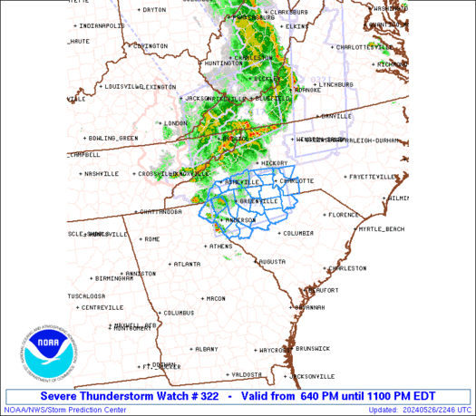
 STATUS REPORT ON WW 322 THE SEVERE WEATHER THREAT CONTINUES ACROSS THE ENTIRE WATCH AREA. ..LYONS..05/27/24 ATTN...WFO...GSP...CAE... STATUS REPORT FOR WS 322 SEVERE WEATHER THREAT CONTINUES FOR THE FOLLOWING AREAS NCC025-045-071-089-109-119-149-161-175-179-270140- NC . NORTH CAROLINA COUNTIES INCLUDED ARE CABARRUS CLEVELAND GASTON HENDERSON LINCOLN MECKLENBURG POLK RUTHERFORD TRANSYLVANIA UNION SCC001-007-021-023-039-045-047-057-059-071-073-077-083-087-091-
270140- SC . SOUTH CAROLINA COUNTIES INCLUDED ARE ABBEVILLE ANDERSON CHEROKEE CHESTER FAIRFIELD GREENVILLE GREENWOOD LANCASTER LAURENS NEWBERRY OCONEE PICKENS SPARTANBURG UNION YORK THE WATCH STATUS MESSAGE IS FOR GUIDANCE PURPOSES ONLY. PLEASE
REFER TO WATCH COUNTY NOTIFICATION STATEMENTS FOR OFFICIAL
SPC Tornado Watch 324
WW 324 TORNADO IL IN KY 262350Z – 270600Z 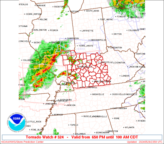
 URGENT - IMMEDIATE BROADCAST REQUESTED
Tornado Watch Number 324
NWS Storm Prediction Center Norman OK
650 PM CDT Sun May 26 2024 The NWS Storm Prediction Center has issued a * Tornado Watch for portions of Southeast Illinois Southern Indiana Western and Central Kentucky * Effective this Sunday night and Monday morning from 650 PM until 100 AM CDT. * Primary threats include... Several tornadoes and a couple intense tornadoes likely Widespread damaging winds and isolated significant gusts to 85 mph likely Scattered large hail and isolated very large hail events to 3 inches in diameter likely SUMMARY...Scattered supercells are forecast to move into the lower
Ohio Valley early this evening and pose a risk for tornadoes, some
potentially strong, and large to very large hail (up 2 to 3 inches
in diameter). Severe gusts are forecast to become more prevalent
later this evening as a severe squall line with embedded supercells
or mesovortices moves across the Watch area. A tornado risk will
probably accompany any stronger line-embedded circulations. The tornado watch area is approximately along and 90 statute miles
east and west of a line from 70 miles north northeast of Evansville
IN to 30 miles south southwest of Bowling Green KY. For a complete
depiction of the watch see the associated watch outline update
(WOUS64 KWNS WOU4). PRECAUTIONARY/PREPAREDNESS ACTIONS... REMEMBER...A Tornado Watch means conditions are favorable for
tornadoes and severe thunderstorms in and close to the watch
area. Persons in these areas should be on the lookout for
threatening weather conditions and listen for later statements
and possible warnings. && OTHER WATCH INFORMATION...CONTINUE...WW 316...WW 317...WW
318...WW 319...WW 320...WW 321...WW 322...WW 323... AVIATION...Tornadoes and a few severe thunderstorms with hail
surface and aloft to 3 inches. Extreme turbulence and surface wind
gusts to 75 knots. A few cumulonimbi with maximum tops to 550. Mean
storm motion vector 24035. ...Smith
SPC Severe Thunderstorm Watch 323
WW 323 SEVERE TSTM IL IN 262320Z – 270400Z
 URGENT - IMMEDIATE BROADCAST REQUESTED
Severe Thunderstorm Watch Number 323
NWS Storm Prediction Center Norman OK
720 PM EDT Sun May 26 2024 The NWS Storm Prediction Center has issued a * Severe Thunderstorm Watch for portions of East-Central Illinois South-Central Indiana * Effective this Sunday night from 720 PM until Midnight EDT. * Primary threats include... Scattered damaging wind gusts to 70 mph likely Isolated large hail events to 1.5 inches in diameter possible SUMMARY...A band of thunderstorms is forecast to intensify across
Illinois and move east into portions of central and southern Indiana
during the evening. Damaging gusts will be the primary severe
hazard, although large hail is possible before the evolving
thunderstorm band becomes more extensive into the mid evening. The severe thunderstorm watch area is approximately along and 30
statute miles north and south of a line from 30 miles west northwest
of Mattoon IL to 60 miles east of Bloomington IN. For a complete
depiction of the watch see the associated watch outline update
(WOUS64 KWNS WOU3). PRECAUTIONARY/PREPAREDNESS ACTIONS... REMEMBER...A Severe Thunderstorm Watch means conditions are
favorable for severe thunderstorms in and close to the watch area.
Persons in these areas should be on the lookout for threatening
weather conditions and listen for later statements and possible
warnings. Severe thunderstorms can and occasionally do produce
tornadoes. && OTHER WATCH INFORMATION...CONTINUE...WW 316...WW 317...WW
318...WW 319...WW 320...WW 321...WW 322... AVIATION...A few severe thunderstorms with hail surface and aloft to
1.5 inches. Extreme turbulence and surface wind gusts to 60 knots. A
few cumulonimbi with maximum tops to 450. Mean storm motion vector
27035. ...Smith
SPC Severe Thunderstorm Watch 322
WW 322 SEVERE TSTM NC SC 262240Z – 270300Z
 URGENT - IMMEDIATE BROADCAST REQUESTED
Severe Thunderstorm Watch Number 322
NWS Storm Prediction Center Norman OK
640 PM EDT Sun May 26 2024 The NWS Storm Prediction Center has issued a * Severe Thunderstorm Watch for portions of Western North Carolina and Piedmont Upstate South Carolina * Effective this Sunday evening from 640 PM until 1100 PM EDT. * Primary threats include... Scattered damaging wind gusts to 70 mph likely Isolated large hail events to 1.5 inches in diameter possible SUMMARY...Widely scattered thunderstorms are forecast to pose a
strong to severe thunderstorm risk this evening. Strong mid-level
flow will support supercell development with the stronger updrafts. Large hail and severe gusts (55-70 mph) are the primary hazards with
the stronger storms. The severe thunderstorm watch area is approximately along and 40
statute miles north and south of a line from 20 miles northwest of
Anderson SC to 25 miles southeast of Charlotte NC. For a complete
depiction of the watch see the associated watch outline update
(WOUS64 KWNS WOU2). PRECAUTIONARY/PREPAREDNESS ACTIONS... REMEMBER...A Severe Thunderstorm Watch means conditions are
favorable for severe thunderstorms in and close to the watch area.
Persons in these areas should be on the lookout for threatening
weather conditions and listen for later statements and possible
warnings. Severe thunderstorms can and occasionally do produce
tornadoes. && OTHER WATCH INFORMATION...CONTINUE...WW 316...WW 317...WW
318...WW 319...WW 320...WW 321... AVIATION...A few severe thunderstorms with hail surface and aloft to
1.5 inches. Extreme turbulence and surface wind gusts to 60 knots. A
few cumulonimbi with maximum tops to 500. Mean storm motion vector
25030. ...Smith
SPC Severe Thunderstorm Watch 321
WW 321 SEVERE TSTM MD NC VA WV 262205Z – 270300Z 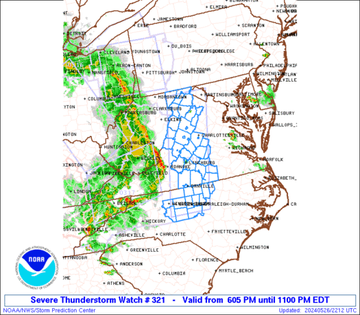
 URGENT - IMMEDIATE BROADCAST REQUESTED
Severe Thunderstorm Watch Number 321
NWS Storm Prediction Center Norman OK
605 PM EDT Sun May 26 2024 The NWS Storm Prediction Center has issued a * Severe Thunderstorm Watch for portions of Far Western Maryland North-Central North Carolina Western and South-Central Virginia Eastern West Virginia * Effective this Sunday evening from 605 PM until 1100 PM EDT. * Primary threats include... Scattered damaging wind gusts to 70 mph possible SUMMARY...An organized and long-lived squall line will likely
continue into the Watch area this evening across western Virginia
northward into far western Maryland. Strong to severe gusts ranging
from 50-70 mph will be capable of wind damage. Farther south, a
couple of strong to severe thunderstorm clusters will probably move
into north-central North Carolina during the evening and potentially
pose a risk for large hail and damaging gusts. The severe thunderstorm watch area is approximately along and 45
statute miles east and west of a line from 35 miles west northwest
of Martinsburg WV to 40 miles southeast of Greensboro NC. For a
complete depiction of the watch see the associated watch outline
update (WOUS64 KWNS WOU1). PRECAUTIONARY/PREPAREDNESS ACTIONS... REMEMBER...A Severe Thunderstorm Watch means conditions are
favorable for severe thunderstorms in and close to the watch area.
Persons in these areas should be on the lookout for threatening
weather conditions and listen for later statements and possible
warnings. Severe thunderstorms can and occasionally do produce
tornadoes. && OTHER WATCH INFORMATION...CONTINUE...WW 316...WW 317...WW
318...WW 319...WW 320... AVIATION...A few severe thunderstorms with hail surface and aloft to
1.5 inches. Extreme turbulence and surface wind gusts to 60 knots. A
few cumulonimbi with maximum tops to 350. Mean storm motion vector
25035. ...Smith