SPC Severe Thunderstorm Watch 387
WW 387 SEVERE TSTM AR LA MS 032355Z – 040500Z 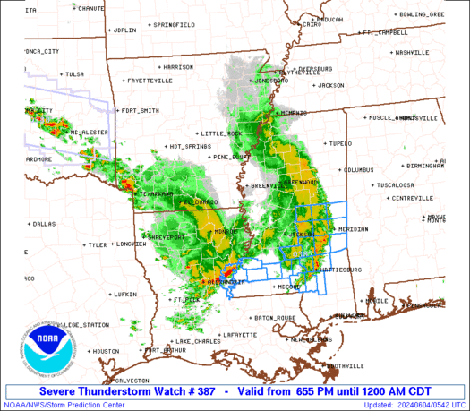
 URGENT - IMMEDIATE BROADCAST REQUESTED
Severe Thunderstorm Watch Number 387
NWS Storm Prediction Center Norman OK
655 PM CDT Mon Jun 3 2024 The NWS Storm Prediction Center has issued a * Severe Thunderstorm Watch for portions of Southeast Arkansas Northeast Louisiana Western Mississippi * Effective this Monday night from 655 PM until Midnight CDT. * Primary threats include... Scattered damaging wind gusts to 70 mph likely Scattered large hail and isolated very large hail events to 2 inches in diameter possible SUMMARY...A line of thunderstorms will spread eastward through the
evening, posing a risk of locally damaging wind gusts across the
watch area. The severe thunderstorm watch area is approximately along and 40
statute miles east and west of a line from 100 miles north northeast
of Greenville MS to 25 miles west southwest of Natchez MS. For a
complete depiction of the watch see the associated watch outline
update (WOUS64 KWNS WOU7). PRECAUTIONARY/PREPAREDNESS ACTIONS... REMEMBER...A Severe Thunderstorm Watch means conditions are
favorable for severe thunderstorms in and close to the watch area.
Persons in these areas should be on the lookout for threatening
weather conditions and listen for later statements and possible
warnings. Severe thunderstorms can and occasionally do produce
tornadoes. && OTHER WATCH INFORMATION...CONTINUE...WW 385...WW 386... AVIATION...A few severe thunderstorms with hail surface and aloft to
2 inches. Extreme turbulence and surface wind gusts to 60 knots. A
few cumulonimbi with maximum tops to 500. Mean storm motion vector
27030. ...Hart