SPC
SPC Severe Thunderstorm Watch 420
WW 420 SEVERE TSTM MT 152155Z – 160300Z 
 URGENT - IMMEDIATE BROADCAST REQUESTED
Severe Thunderstorm Watch Number 420
NWS Storm Prediction Center Norman OK
355 PM MDT Sat Jun 15 2024 The NWS Storm Prediction Center has issued a * Severe Thunderstorm Watch for portions of Central and Eastern Montana * Effective this Saturday afternoon and evening from 355 PM until 900 PM MDT. * Primary threats include... Scattered damaging winds and isolated significant gusts to 85 mph likely Isolated very large hail events to 2 inches in diameter possible A tornado or two possible SUMMARY...An intensifying broken band of thunderstorms is forecast
to grow upscale into a squall line this afternoon and into the
evening across the Watch area. Severe gusts (60-85 mph) will be the
primary hazard with the band of storms. Large hail may accompany
any more discrete storm on the south flank of the evolving
thunderstorm activity during the evening, as well as perhaps a brief
risk for a tornado. The severe thunderstorm watch area is approximately along and 95
statute miles east and west of a line from 55 miles north northeast
of Glasgow MT to 35 miles south southwest of Miles City MT. For a
complete depiction of the watch see the associated watch outline
update (WOUS64 KWNS WOU0). PRECAUTIONARY/PREPAREDNESS ACTIONS... REMEMBER...A Severe Thunderstorm Watch means conditions are
favorable for severe thunderstorms in and close to the watch area.
Persons in these areas should be on the lookout for threatening
weather conditions and listen for later statements and possible
warnings. Severe thunderstorms can and occasionally do produce
tornadoes. && OTHER WATCH INFORMATION...CONTINUE...WW 417...WW 418...WW 419... AVIATION...A few severe thunderstorms with hail surface and aloft to
2 inches. Extreme turbulence and surface wind gusts to 75 knots. A
few cumulonimbi with maximum tops to 450. Mean storm motion vector
26040. ...Smith
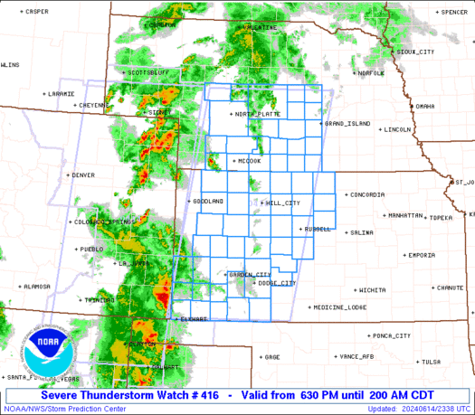
SPC Severe Thunderstorm Watch 419
WW 419 SEVERE TSTM KS 152135Z – 160300Z 
 URGENT - IMMEDIATE BROADCAST REQUESTED
Severe Thunderstorm Watch Number 419
NWS Storm Prediction Center Norman OK
435 PM CDT Sat Jun 15 2024 The NWS Storm Prediction Center has issued a * Severe Thunderstorm Watch for portions of Central and Eastern Kansas * Effective this Saturday afternoon and evening from 435 PM until 1000 PM CDT. * Primary threats include... Scattered damaging winds and isolated significant gusts to 80 mph possible Isolated large hail events to 1.5 inches in diameter possible SUMMARY...Isolated to scattered thunderstorms will continue to
develop this afternoon into the evening. The stronger thunderstorms
will mainly be capable of severe gusts (60-80 mph). Isolated large
hail may also accompany the more intense thunderstorm cores as this
activity moves east into a more unstable airmass over eastern parts
of Kansas towards the early evening. The severe thunderstorm watch area is approximately along and 55
statute miles east and west of a line from 45 miles northeast of
Manhattan KS to 40 miles south of Wichita KS. For a complete
depiction of the watch see the associated watch outline update
(WOUS64 KWNS WOU9). PRECAUTIONARY/PREPAREDNESS ACTIONS... REMEMBER...A Severe Thunderstorm Watch means conditions are
favorable for severe thunderstorms in and close to the watch area.
Persons in these areas should be on the lookout for threatening
weather conditions and listen for later statements and possible
warnings. Severe thunderstorms can and occasionally do produce
tornadoes. && OTHER WATCH INFORMATION...CONTINUE...WW 417...WW 418... AVIATION...A few severe thunderstorms with hail surface and aloft to
1.5 inches. Extreme turbulence and surface wind gusts to 70 knots. A
few cumulonimbi with maximum tops to 450. Mean storm motion vector
21030. ...Smith
SPC Tornado Watch 418
WW 418 TORNADO IA KS MN MO NE SD 152050Z – 160300Z 
 URGENT - IMMEDIATE BROADCAST REQUESTED
Tornado Watch Number 418
NWS Storm Prediction Center Norman OK
350 PM CDT Sat Jun 15 2024 The NWS Storm Prediction Center has issued a * Tornado Watch for portions of Western Iowa Northeast Kansas Far Southwest Minnesota Extreme Northwest Missouri Eastern Nebraska Southeast South Dakota * Effective this Saturday afternoon and evening from 350 PM until 1000 PM CDT. * Primary threats include... A few tornadoes and a couple intense tornadoes possible Scattered large hail and isolated very large hail events to 2 inches in diameter possible Scattered damaging wind gusts to 70 mph possible SUMMARY...Thunderstorms will continue to develop and pose a threat
for a few tornadoes, large hail, and damaging winds this afternoon
and evening as they spread east-northeastward. The tornado watch area is approximately along and 55 statute miles
east and west of a line from 55 miles east northeast of Yankton SD
to 45 miles south of Beatrice NE. For a complete depiction of the
watch see the associated watch outline update (WOUS64 KWNS WOU8). PRECAUTIONARY/PREPAREDNESS ACTIONS... REMEMBER...A Tornado Watch means conditions are favorable for
tornadoes and severe thunderstorms in and close to the watch
area. Persons in these areas should be on the lookout for
threatening weather conditions and listen for later statements
and possible warnings. && OTHER WATCH INFORMATION...CONTINUE...WW 417... AVIATION...Tornadoes and a few severe thunderstorms with hail
surface and aloft to 2 inches. Extreme turbulence and surface wind
gusts to 60 knots. A few cumulonimbi with maximum tops to 550. Mean
storm motion vector 25030. ...Gleason
SPC Severe Thunderstorm Watch 417
WW 417 SEVERE TSTM SD 152025Z – 160300Z 
 URGENT - IMMEDIATE BROADCAST REQUESTED
Severe Thunderstorm Watch Number 417
NWS Storm Prediction Center Norman OK
225 PM MDT Sat Jun 15 2024 The NWS Storm Prediction Center has issued a * Severe Thunderstorm Watch for portions of Western and Central South Dakota * Effective this Saturday afternoon and evening from 225 PM until 900 PM MDT. * Primary threats include... Scattered damaging winds and isolated significant gusts to 75 mph possible Scattered large hail and isolated very large hail events to 2 inches in diameter possible SUMMARY...Thunderstorms should continue developing over the Black
Hills this afternoon. Large hail around 1-2 inches in diameter along
with severe/damaging winds of 60-75 mph will be possible as this
convection spreads eastward across parts of western and central
South Dakota through this evening. The severe thunderstorm watch area is approximately along and 85
statute miles east and west of a line from Lemmon SD to 35 miles
west southwest of Philip SD. For a complete depiction of the watch
see the associated watch outline update (WOUS64 KWNS WOU7). PRECAUTIONARY/PREPAREDNESS ACTIONS... REMEMBER...A Severe Thunderstorm Watch means conditions are
favorable for severe thunderstorms in and close to the watch area.
Persons in these areas should be on the lookout for threatening
weather conditions and listen for later statements and possible
warnings. Severe thunderstorms can and occasionally do produce
tornadoes. && AVIATION...A few severe thunderstorms with hail surface and aloft to
2 inches. Extreme turbulence and surface wind gusts to 65 knots. A
few cumulonimbi with maximum tops to 500. Mean storm motion vector
27035. ...Gleason
SPC – No watches are valid as of Sat Jun 15 07:02:02 UTC 2024
No watches are valid as of Sat Jun 15 07:02:02 UTC 2024.