SPC – No watches are valid as of Fri May 23 06:02:02 UTC 2025
No watches are valid as of Fri May 23 06:02:02 UTC 2025.
24/7 Tornado Newsfeed
No watches are valid as of Fri May 23 06:02:02 UTC 2025.
WW 311 SEVERE TSTM OK TX 221555Z – 222100Z 
 URGENT - IMMEDIATE BROADCAST REQUESTED
Severe Thunderstorm Watch Number 311
NWS Storm Prediction Center Norman OK
1055 AM CDT Thu May 22 2025 The NWS Storm Prediction Center has issued a * Severe Thunderstorm Watch for portions of Southern and East-Central Oklahoma North Texas * Effective this Thursday morning and afternoon from 1055 AM until 400 PM CDT. * Primary threats include... Scattered large hail likely with isolated very large hail events to 2.5 inches in diameter possible Scattered damaging wind gusts to 70 mph possible SUMMARY...Clusters of storms will continue to spread generally
east-southeastward across the region, with large hail possible. The
most intense storms are expected across southern Oklahoma into parts
of North Texas, where damaging wind potential may also increase this
afternoon. The severe thunderstorm watch area is approximately along and 70
statute miles east and west of a line from 40 miles west northwest
of Muskogee OK to 35 miles south of Sherman TX. For a complete
depiction of the watch see the associated watch outline update
(WOUS64 KWNS WOU1). PRECAUTIONARY/PREPAREDNESS ACTIONS... REMEMBER...A Severe Thunderstorm Watch means conditions are
favorable for severe thunderstorms in and close to the watch area.
Persons in these areas should be on the lookout for threatening
weather conditions and listen for later statements and possible
warnings. Severe thunderstorms can and occasionally do produce
tornadoes. && AVIATION...A few severe thunderstorms with hail surface and aloft to
2.5 inches. Extreme turbulence and surface wind gusts to 60 knots. A
few cumulonimbi with maximum tops to 500. Mean storm motion vector
29020. ...Guyer
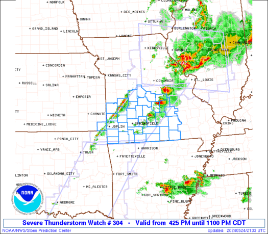
WW 310 TORNADO OH PA WV 211840Z – 220000Z 
 URGENT - IMMEDIATE BROADCAST REQUESTED
Tornado Watch Number 310
NWS Storm Prediction Center Norman OK
240 PM EDT Wed May 21 2025 The NWS Storm Prediction Center has issued a * Tornado Watch for portions of Eastern Ohio Western Pennsylvania Far Northern West Virginia * Effective this Wednesday afternoon and evening from 240 PM until 800 PM EDT. * Primary threats include... A couple tornadoes possible Scattered damaging wind gusts to 65 mph possible Isolated large hail events to 1.5 inches in diameter possible SUMMARY...Low-topped supercell and related hail/wind and tornado
potential should focus in a narrow zone regionally near a warm front
this afternoon until around sunset. The tornado watch area is approximately along and 50 statute miles
east and west of a line from 35 miles north northwest of Pittsburgh
PA to 30 miles west southwest of Morgantown WV. For a complete
depiction of the watch see the associated watch outline update
(WOUS64 KWNS WOU0). PRECAUTIONARY/PREPAREDNESS ACTIONS... REMEMBER...A Tornado Watch means conditions are favorable for
tornadoes and severe thunderstorms in and close to the watch
area. Persons in these areas should be on the lookout for
threatening weather conditions and listen for later statements
and possible warnings. && AVIATION...Tornadoes and a few severe thunderstorms with hail
surface and aloft to 1.5 inches. Extreme turbulence and surface wind
gusts to 55 knots. A few cumulonimbi with maximum tops to 500. Mean
storm motion vector 23025. ...Guyer
No watches are valid as of Wed May 21 07:02:02 UTC 2025.
WW 308 TORNADO GA KY NC TN VA 202325Z – 210600Z 
 URGENT - IMMEDIATE BROADCAST REQUESTED
Tornado Watch Number 308
NWS Storm Prediction Center Norman OK
725 PM EDT Tue May 20 2025 The NWS Storm Prediction Center has issued a * Tornado Watch for portions of Northern Georgia Eastern Kentucky Far Southwest North Carolina Eastern Tennessee Far Southwest Virginia * Effective this Tuesday night and Wednesday morning from 725 PM until 200 AM EDT. * Primary threats include... A few tornadoes likely with a couple intense tornadoes possible Scattered damaging wind gusts to 70 mph likely Scattered large hail and isolated very large hail events to 2.5 inches in diameter possible SUMMARY...A mix of supercell thunderstorms and clusters will spread
generally eastward this evening into the early overnight hours. A
few tornadoes may occur with this activity, and a strong tornado and
isolated very large hail will also be possible with any sustained
supercell. Otherwise, an increasing threat for scattered to numerous
damaging winds appears likely as thunderstorms attempt to organize
into a line later this evening. Peak gusts may reach up to 60-70
mph. The tornado watch area is approximately along and 50 statute miles
east and west of a line from 35 miles north northeast of London KY
to 20 miles southeast of Rome GA. For a complete depiction of the
watch see the associated watch outline update (WOUS64 KWNS WOU8). PRECAUTIONARY/PREPAREDNESS ACTIONS... REMEMBER...A Tornado Watch means conditions are favorable for
tornadoes and severe thunderstorms in and close to the watch
area. Persons in these areas should be on the lookout for
threatening weather conditions and listen for later statements
and possible warnings. && OTHER WATCH INFORMATION...CONTINUE...WW 303...WW 304...WW
305...WW 306...WW 307... AVIATION...Tornadoes and a few severe thunderstorms with hail
surface and aloft to 2.5 inches. Extreme turbulence and surface wind
gusts to 60 knots. A few cumulonimbi with maximum tops to 550. Mean
storm motion vector 26030. ...Gleason
WW 305 TORNADO AL GA IL IN KY TN 201935Z – 210300Z 
 URGENT - IMMEDIATE BROADCAST REQUESTED
Tornado Watch Number 305
NWS Storm Prediction Center Norman OK
235 PM CDT Tue May 20 2025 The NWS Storm Prediction Center has issued a * Tornado Watch for portions of Northern Alabama Northwest Georgia Southeast Illinois Southwest Indiana Central Kentucky Middle Tennessee * Effective this Tuesday afternoon and evening from 235 PM until 1000 PM CDT. * Primary threats include... A few tornadoes likely with a couple intense tornadoes possible Scattered large hail likely with isolated very large hail events to 2.5 inches in diameter possible Scattered damaging wind gusts to 70 mph likely SUMMARY...Thunderstorms will spread quickly eastward across the
watch area through the afternoon and early evening hours. Damaging
winds, large hail, and a few tornadoes are expected. The tornado watch area is approximately along and 85 statute miles
east and west of a line from 50 miles north of Bowling Green KY to
35 miles south of Huntsville AL. For a complete depiction of the
watch see the associated watch outline update (WOUS64 KWNS WOU5). PRECAUTIONARY/PREPAREDNESS ACTIONS... REMEMBER...A Tornado Watch means conditions are favorable for
tornadoes and severe thunderstorms in and close to the watch
area. Persons in these areas should be on the lookout for
threatening weather conditions and listen for later statements
and possible warnings. && OTHER WATCH INFORMATION...CONTINUE...WW 302...WW 303...WW 304... AVIATION...Tornadoes and a few severe thunderstorms with hail
surface and aloft to 2.5 inches. Extreme turbulence and surface wind
gusts to 60 knots. A few cumulonimbi with maximum tops to 500. Mean
storm motion vector 25030. ...Hart