NOAA
SPC Tornado Watch 258
WW 258 TORNADO MI LE LH 160330Z – 160900Z 
 URGENT - IMMEDIATE BROADCAST REQUESTED
Tornado Watch Number 258
NWS Storm Prediction Center Norman OK
1130 PM EDT Thu May 15 2025 The NWS Storm Prediction Center has issued a * Tornado Watch for portions of Eastern Lower Michigan Lake Erie Lake Huron * Effective this Thursday night and Friday morning from 1130 PM until 500 AM EDT. * Primary threats include... A couple tornadoes possible Scattered damaging winds likely with isolated significant gusts to 75 mph possible Isolated large hail events to 1.5 inches in diameter possible SUMMARY...A well-organized thunderstorm cluster should continue to
pose a threat for scattered severe/damaging winds and a couple of
tornadoes as it moves quickly eastward across Lower Michigan. The tornado watch area is approximately along and 50 statute miles
east and west of a line from 35 miles northwest of Bad Axe MI to 35
miles south of Ann Arbor MI. For a complete depiction of the watch
see the associated watch outline update (WOUS64 KWNS WOU8). PRECAUTIONARY/PREPAREDNESS ACTIONS... REMEMBER...A Tornado Watch means conditions are favorable for
tornadoes and severe thunderstorms in and close to the watch
area. Persons in these areas should be on the lookout for
threatening weather conditions and listen for later statements
and possible warnings. && OTHER WATCH INFORMATION...CONTINUE...WW 256...WW 257... AVIATION...Tornadoes and a few severe thunderstorms with hail
surface and aloft to 1.5 inches. Extreme turbulence and surface wind
gusts to 65 knots. A few cumulonimbi with maximum tops to 500. Mean
storm motion vector 25045. ...Gleason
SPC Tornado Watch 257
WW 257 TORNADO IN MI LM 160130Z – 160700Z 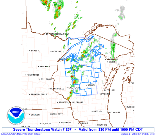
 URGENT - IMMEDIATE BROADCAST REQUESTED
Tornado Watch Number 257
NWS Storm Prediction Center Norman OK
930 PM EDT Thu May 15 2025 The NWS Storm Prediction Center has issued a * Tornado Watch for portions of Northern and West-Central Indiana Far Southern Lower Michigan Lake Michigan * Effective this Thursday night and Friday morning from 930 PM until 300 AM EDT. * Primary threats include... A few tornadoes and a couple intense tornadoes possible Scattered damaging winds likely with isolated significant gusts to 75 mph possible Scattered large hail and isolated very large hail events to 2.5 inches in diameter possible SUMMARY...Thunderstorms will spread east-northeastward this evening
and overnight while posing a threat for a few tornadoes, scattered
severe/damaging winds with the ongoing cluster, and large hail with
any sustained supercells. The tornado watch area is approximately along and 45 statute miles
east and west of a line from 30 miles east of Benton Harbor MI to 90
miles south of South Bend IN. For a complete depiction of the watch
see the associated watch outline update (WOUS64 KWNS WOU7). PRECAUTIONARY/PREPAREDNESS ACTIONS... REMEMBER...A Tornado Watch means conditions are favorable for
tornadoes and severe thunderstorms in and close to the watch
area. Persons in these areas should be on the lookout for
threatening weather conditions and listen for later statements
and possible warnings. && OTHER WATCH INFORMATION...CONTINUE...WW 253...WW 255...WW 256... AVIATION...Tornadoes and a few severe thunderstorms with hail
surface and aloft to 2.5 inches. Extreme turbulence and surface wind
gusts to 65 knots. A few cumulonimbi with maximum tops to 500. Mean
storm motion vector 24040. ...Gleason
SPC Tornado Watch 255
WW 255 TORNADO IL IN LM 152215Z – 160300Z 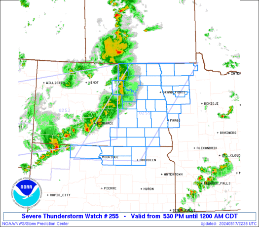
 URGENT - IMMEDIATE BROADCAST REQUESTED
Tornado Watch Number 255
NWS Storm Prediction Center Norman OK
515 PM CDT Thu May 15 2025 The NWS Storm Prediction Center has issued a * Tornado Watch for portions of Northern and Central Illinois Far Northwest Indiana Lake Michigan * Effective this Thursday afternoon and evening from 515 PM until 1000 PM CDT. * Primary threats include... A few tornadoes and a couple intense tornadoes possible Scattered large hail and isolated very large hail events to 3 inches in diameter likely Scattered damaging winds likely with isolated significant gusts to 75 mph possible SUMMARY...Supercell thunderstorms will pose a threat for large to
very large hail this evening as they move east-northeastward. The
largest hailstones may reach up to 2-3 inches in diameter. A few
tornadoes are also possible, and a strong tornado may occur.
Otherwise, scattered severe/damaging winds should also be a threat,
especially if thunderstorms can congeal into clusters later this
evening. The tornado watch area is approximately along and 70 statute miles
east and west of a line from 60 miles north northeast of Marseilles
IL to 35 miles west southwest of Champaign IL. For a complete
depiction of the watch see the associated watch outline update
(WOUS64 KWNS WOU5). PRECAUTIONARY/PREPAREDNESS ACTIONS... REMEMBER...A Tornado Watch means conditions are favorable for
tornadoes and severe thunderstorms in and close to the watch
area. Persons in these areas should be on the lookout for
threatening weather conditions and listen for later statements
and possible warnings. && OTHER WATCH INFORMATION...CONTINUE...WW 251...WW 252...WW
253...WW 254... AVIATION...Tornadoes and a few severe thunderstorms with hail
surface and aloft to 3 inches. Extreme turbulence and surface wind
gusts to 65 knots. A few cumulonimbi with maximum tops to 500. Mean
storm motion vector 23035. ...Gleason
SPC Severe Thunderstorm Watch 254
WW 254 SEVERE TSTM NC VA WV CW 152105Z – 160400Z 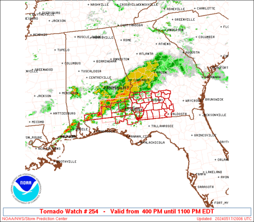
 URGENT - IMMEDIATE BROADCAST REQUESTED
Severe Thunderstorm Watch Number 254
NWS Storm Prediction Center Norman OK
505 PM EDT Thu May 15 2025 The NWS Storm Prediction Center has issued a * Severe Thunderstorm Watch for portions of North-Central/Northeast North Carolina Central and Eastern Virginia Far Eastern West Virginia Coastal Waters * Effective this Thursday afternoon from 505 PM until Midnight EDT. * Primary threats include... Scattered large hail and isolated very large hail events to 2 inches in diameter possible Scattered damaging wind gusts to 70 mph possible SUMMARY...Thunderstorm coverage is expected to increase over the
next few hours. Environmental conditions across the region favor a
cellular mode, including the potential for supercells capable of
large to very large hail. Some damaging gusts are possible as well. The severe thunderstorm watch area is approximately along and 90
statute miles east and west of a line from 55 miles north of
Lynchburg VA to 40 miles south southwest of Roanoke Rapids NC. For a
complete depiction of the watch see the associated watch outline
update (WOUS64 KWNS WOU4). PRECAUTIONARY/PREPAREDNESS ACTIONS... REMEMBER...A Severe Thunderstorm Watch means conditions are
favorable for severe thunderstorms in and close to the watch area.
Persons in these areas should be on the lookout for threatening
weather conditions and listen for later statements and possible
warnings. Severe thunderstorms can and occasionally do produce
tornadoes. && OTHER WATCH INFORMATION...CONTINUE...WW 251...WW 252...WW 253... AVIATION...A few severe thunderstorms with hail surface and aloft to
2 inches. Extreme turbulence and surface wind gusts to 60 knots. A
few cumulonimbi with maximum tops to 500. Mean storm motion vector
29030. ...Mosier
SPC Tornado Watch 253
WW 253 TORNADO IL WI 152005Z – 160300Z 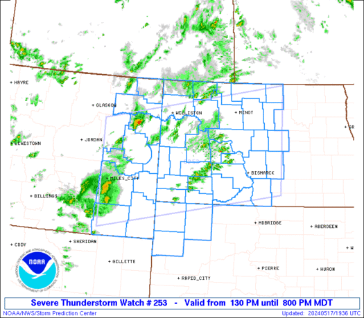
 URGENT - IMMEDIATE BROADCAST REQUESTED
Tornado Watch Number 253
NWS Storm Prediction Center Norman OK
305 PM CDT Thu May 15 2025 The NWS Storm Prediction Center has issued a * Tornado Watch for portions of Far Northern Illinois Central/Eastern/Southern Wisconsin * Effective this Thursday afternoon and evening from 305 PM until 1000 PM CDT. * Primary threats include... A few tornadoes and a couple intense tornadoes possible Scattered large hail and isolated very large hail events to 3 inches in diameter likely Scattered damaging wind gusts to 70 mph likely SUMMARY...Thunderstorms are expected to develop along a warm front
and move into the region over the next several hours. Environmental
conditions support supercells capable of all severe hazards,
including large to very large hail and tornadoes. The tornado watch area is approximately along and 60 statute miles
east and west of a line from 40 miles northeast of Wausau WI to 20
miles south southwest of Janesville WI. For a complete depiction of
the watch see the associated watch outline update (WOUS64 KWNS
WOU3). PRECAUTIONARY/PREPAREDNESS ACTIONS... REMEMBER...A Tornado Watch means conditions are favorable for
tornadoes and severe thunderstorms in and close to the watch
area. Persons in these areas should be on the lookout for
threatening weather conditions and listen for later statements
and possible warnings. && OTHER WATCH INFORMATION...CONTINUE...WW 251...WW 252... AVIATION...Tornadoes and a few severe thunderstorms with hail
surface and aloft to 3 inches. Extreme turbulence and surface wind
gusts to 60 knots. A few cumulonimbi with maximum tops to 500. Mean
storm motion vector 21030. ...Mosier