NOAA
SPC Severe Thunderstorm Watch 255
WW 255 SEVERE TSTM MN ND SD 172230Z – 180500Z 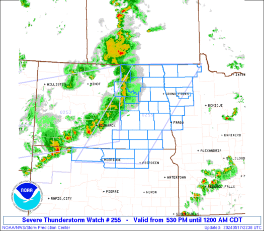
 URGENT - IMMEDIATE BROADCAST REQUESTED
Severe Thunderstorm Watch Number 255
NWS Storm Prediction Center Norman OK
530 PM CDT Fri May 17 2024 The NWS Storm Prediction Center has issued a * Severe Thunderstorm Watch for portions of Northwest Minnesota Eastern North Dakota Northern South Dakota * Effective this Friday afternoon from 530 PM until Midnight CDT. * Primary threats include... Scattered damaging wind gusts to 70 mph likely Isolated large hail events to 1.5 inches in diameter possible SUMMARY...A broken band of strong to severe thunderstorms will
likely move east into the Watch area during the evening from the
west. Severe gusts ranging from 60-70 mph and perhaps large hail
are the main threats with the more intense thunderstorms. The severe thunderstorm watch area is approximately along and 85
statute miles east and west of a line from 20 miles north of Hallock
MN to 20 miles east southeast of Mobridge SD. For a complete
depiction of the watch see the associated watch outline update
(WOUS64 KWNS WOU5). PRECAUTIONARY/PREPAREDNESS ACTIONS... REMEMBER...A Severe Thunderstorm Watch means conditions are
favorable for severe thunderstorms in and close to the watch area.
Persons in these areas should be on the lookout for threatening
weather conditions and listen for later statements and possible
warnings. Severe thunderstorms can and occasionally do produce
tornadoes. && OTHER WATCH INFORMATION...CONTINUE...WW 253...WW 254... AVIATION...A few severe thunderstorms with hail surface and aloft to
1.5 inches. Extreme turbulence and surface wind gusts to 60 knots. A
few cumulonimbi with maximum tops to 400. Mean storm motion vector
25035. ...Smith
SPC Tornado Watch 254
WW 254 TORNADO AL FL GA 172000Z – 180300Z 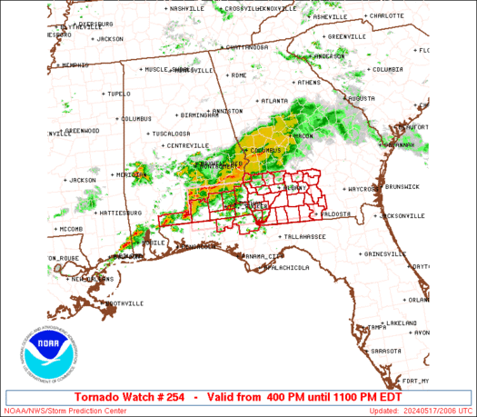
 URGENT - IMMEDIATE BROADCAST REQUESTED
Tornado Watch Number 254
NWS Storm Prediction Center Norman OK
400 PM EDT Fri May 17 2024 The NWS Storm Prediction Center has issued a * Tornado Watch for portions of Southeast Alabama Northern Florida Panhandle Southwest Georgia * Effective this Friday afternoon and evening from 400 PM until 1100 PM EDT. * Primary threats include... A few tornadoes possible Scattered large hail likely with isolated very large hail events to 2 inches in diameter possible Scattered damaging wind gusts to 70 mph likely SUMMARY...Thunderstorms will intensify this afternoon along a
surface boundary and track eastward across the watch area. Locally
severe storms are expected, with damaging winds, hail, and a few
tornadoes possible. The tornado watch area is approximately along and 35 statute miles
north and south of a line from 75 miles west of Dothan AL to 30
miles east northeast of Moultrie GA. For a complete depiction of the
watch see the associated watch outline update (WOUS64 KWNS WOU4). PRECAUTIONARY/PREPAREDNESS ACTIONS... REMEMBER...A Tornado Watch means conditions are favorable for
tornadoes and severe thunderstorms in and close to the watch
area. Persons in these areas should be on the lookout for
threatening weather conditions and listen for later statements
and possible warnings. && OTHER WATCH INFORMATION...CONTINUE...WW 253... AVIATION...Tornadoes and a few severe thunderstorms with hail
surface and aloft to 2 inches. Extreme turbulence and surface wind
gusts to 60 knots. A few cumulonimbi with maximum tops to 500. Mean
storm motion vector 27030. ...Hart
SPC Severe Thunderstorm Watch 253
WW 253 SEVERE TSTM MT ND SD 171930Z – 180200Z 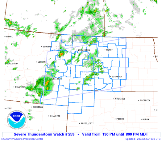
 URGENT - IMMEDIATE BROADCAST REQUESTED
Severe Thunderstorm Watch Number 253
NWS Storm Prediction Center Norman OK
130 PM MDT Fri May 17 2024 The NWS Storm Prediction Center has issued a * Severe Thunderstorm Watch for portions of Eastern Montana Western and Central North Dakota Northwest South Dakota * Effective this Friday afternoon and evening from 130 PM until 800 PM MDT. * Primary threats include... Scattered damaging winds likely with isolated significant gusts to 75 mph possible Isolated large hail events to 1.5 inches in diameter possible SUMMARY...Scattered thunderstorms will develop and spread across the
watch area through the afternoon and early evening. The strongest
cells will pose a risk of locally damaging wind gusts. The severe thunderstorm watch area is approximately along and 95
statute miles north and south of a line from 15 miles northwest of
Miles City MT to 80 miles northeast of Bismarck ND. For a complete
depiction of the watch see the associated watch outline update
(WOUS64 KWNS WOU3). PRECAUTIONARY/PREPAREDNESS ACTIONS... REMEMBER...A Severe Thunderstorm Watch means conditions are
favorable for severe thunderstorms in and close to the watch area.
Persons in these areas should be on the lookout for threatening
weather conditions and listen for later statements and possible
warnings. Severe thunderstorms can and occasionally do produce
tornadoes. && AVIATION...A few severe thunderstorms with hail surface and aloft to
1.5 inches. Extreme turbulence and surface wind gusts to 65 knots. A
few cumulonimbi with maximum tops to 450. Mean storm motion vector
27035. ...Hart
SPC – No watches are valid as of Fri May 17 08:02:02 UTC 2024
No watches are valid as of Fri May 17 08:02:02 UTC 2024.
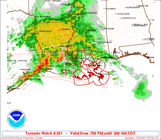
SPC Tornado Watch 252
WW 252 TORNADO AL MS CW 170350Z – 170800Z 
 URGENT - IMMEDIATE BROADCAST REQUESTED
Tornado Watch Number 252
NWS Storm Prediction Center Norman OK
1050 PM CDT Thu May 16 2024 The NWS Storm Prediction Center has issued a * Tornado Watch for portions of Southern Alabama Southern Mississippi Coastal Waters * Effective this Thursday night and Friday morning from 1050 PM until 300 AM CDT. * Primary threats include... A couple tornadoes possible Isolated damaging wind gusts to 70 mph possible SUMMARY...A severe squall line over southeast Louisiana will
continue east and move into the Watch area tonight. In addition to
the risk for a couple of tornadoes, severe gusts (60-70 mph) capable
of wind damage may accompany the more intense thunderstorm cores and
outflow surges in the squall line. The tornado watch area is approximately along and 30 statute miles
north and south of a line from 35 miles west of Gulfport MS to 30
miles southeast of Mobile AL. For a complete depiction of the watch
see the associated watch outline update (WOUS64 KWNS WOU2). PRECAUTIONARY/PREPAREDNESS ACTIONS... REMEMBER...A Tornado Watch means conditions are favorable for
tornadoes and severe thunderstorms in and close to the watch
area. Persons in these areas should be on the lookout for
threatening weather conditions and listen for later statements
and possible warnings. && OTHER WATCH INFORMATION...CONTINUE...WW 250...WW 251... AVIATION...Tornadoes and a few severe thunderstorms with hail
surface and aloft to 1.5 inches. Extreme turbulence and surface wind
gusts to 60 knots. A few cumulonimbi with maximum tops to 500. Mean
storm motion vector 27035. ...Smith