Note:
The expiration time in the watch graphic is amended if the watch is
replaced, cancelled or extended.
Note: Click for Watch Status Reports.
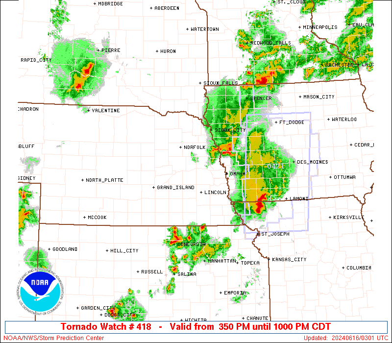
SEL8 URGENT - IMMEDIATE BROADCAST REQUESTED Tornado Watch Number 418 NWS Storm Prediction Center Norman OK 350 PM CDT Sat Jun 15 2024 The NWS Storm Prediction Center has issued a * Tornado Watch for portions of Western Iowa Northeast Kansas Far Southwest Minnesota Extreme Northwest Missouri Eastern Nebraska Southeast South Dakota * Effective this Saturday afternoon and evening from 350 PM until 1000 PM CDT. * Primary threats include... A few tornadoes and a couple intense tornadoes possible Scattered large hail and isolated very large hail events to 2 inches in diameter possible Scattered damaging wind gusts to 70 mph possible SUMMARY...Thunderstorms will continue to develop and pose a threat for a few tornadoes, large hail, and damaging winds this afternoon and evening as they spread east-northeastward. The tornado watch area is approximately along and 55 statute miles east and west of a line from 55 miles east northeast of Yankton SD to 45 miles south of Beatrice NE. For a complete depiction of the watch see the associated watch outline update (WOUS64 KWNS WOU8). PRECAUTIONARY/PREPAREDNESS ACTIONS... REMEMBER...A Tornado Watch means conditions are favorable for tornadoes and severe thunderstorms in and close to the watch area. Persons in these areas should be on the lookout for threatening weather conditions and listen for later statements and possible warnings. && OTHER WATCH INFORMATION...CONTINUE...WW 417... AVIATION...Tornadoes and a few severe thunderstorms with hail surface and aloft to 2 inches. Extreme turbulence and surface wind gusts to 60 knots. A few cumulonimbi with maximum tops to 550. Mean storm motion vector 25030. ...Gleason