Note:
The expiration time in the watch graphic is amended if the watch is
replaced, cancelled or extended.
Note: Click for Watch Status Reports.
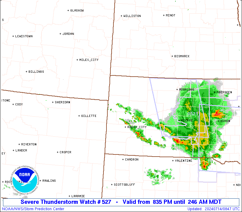
SEL7 URGENT - IMMEDIATE BROADCAST REQUESTED Severe Thunderstorm Watch Number 527 NWS Storm Prediction Center Norman OK 835 PM MDT Sat Jul 13 2024 The NWS Storm Prediction Center has issued a * Severe Thunderstorm Watch for portions of Western South Dakota Far Northeast Wyoming * Effective this Saturday night and Sunday morning from 835 PM until 300 AM MDT. * Primary threats include... Scattered damaging winds likely with isolated significant gusts to 75 mph possible Scattered large hail and isolated very large hail events to 2 inches in diameter possible SUMMARY...Intense thunderstorms will move quickly southeastward across western South Dakota this evening while posing a threat for severe/damaging winds generally up to 65-75 mph, and large hail around 1-2 inches in diameter. The severe thunderstorm watch area is approximately along and 60 statute miles east and west of a line from 20 miles north of Buffalo SD to 30 miles east southeast of Rapid City SD. For a complete depiction of the watch see the associated watch outline update (WOUS64 KWNS WOU7). PRECAUTIONARY/PREPAREDNESS ACTIONS... REMEMBER...A Severe Thunderstorm Watch means conditions are favorable for severe thunderstorms in and close to the watch area. Persons in these areas should be on the lookout for threatening weather conditions and listen for later statements and possible warnings. Severe thunderstorms can and occasionally do produce tornadoes. && OTHER WATCH INFORMATION...CONTINUE...WW 522...WW 523...WW 524...WW 525...WW 526... AVIATION...A few severe thunderstorms with hail surface and aloft to 2 inches. Extreme turbulence and surface wind gusts to 65 knots. A few cumulonimbi with maximum tops to 500. Mean storm motion vector 32040. ...Gleason