
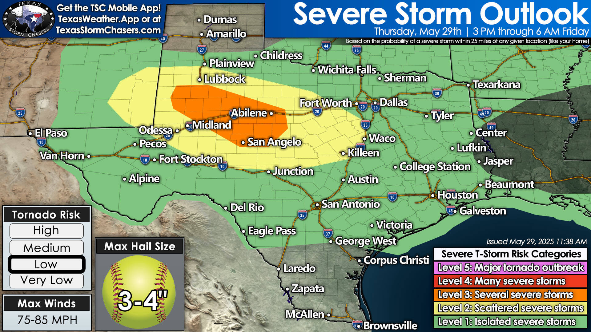
The Storm Prediction Center has issued a midday upgrade to today’s severe weather outlook, now placing parts of the Permian Basin, Big Country, and Concho Valley under a Level 3 (Enhanced) Risk for severe thunderstorms. This is a notable escalation from this morning’s outlook and reflects growing concern over the potential for destructive storms later today and tonight.

 What’s Changed?
The biggest headline with this update is the increased threat for hurricane-force wind gusts and very large hail:
-
 Wind Gusts: Now expected to reach 75–85 MPH, strong enough to cause tree damage, power outages, and structural impacts.
 -
 Hail Size: Forecasts now suggest hail up to 3 to 4 inches in diameter — roughly the size of softballs. That’s large enough to damage roofs, windows, and vehicles.
 -
Tornado Risk: Remains low, but not zero. Isolated tornadoes are still possible, particularly with any discrete supercells this afternoon.
 Timing & Areas of Concern
-
Storm Development: Isolated supercells may form by mid to late afternoon in the Trans-Pecos and eastern New Mexico, moving eastward through the evening.
-
Greatest Impact Window: 5 PM to Midnight as storms consolidate into a cluster or line, pushing southeast across affected regions.
-
At-Risk Cities: Midland, San Angelo, Abilene, and nearby communities should closely monitor conditions this evening.
 Want the Full Forecast?
For a detailed breakdown of today’s storm setup, plus an extended look into Texas’s active weather pattern heading into early June, check out our morning forecast blog post:
 Texas Daily Storm Chances Through Next Week – Full Forecast
 What You Should Do
-
Bring in vehicles, pets, and anything that could be damaged by large hail or high wind.
-
Review your severe weather safety plan now — especially if you live in a mobile home or vulnerable structure.
-
Make sure your weather alerts are turned on and working properly.
-
Download our free Texas Storm Chasers app to stay informed on the go:
 https://texasweather.app
 Programming Note – No Live Coverage Today
Due to scheduling conflicts, we won’t be able to provide live severe weather coverage today. We know this is a day many are watching closely, and we encourage everyone to stay weather-aware and use reliable sources for alerts.