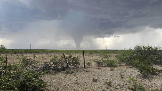
Another day, another severe weather threat in Texas as thunderstorms are forecast to fire early Saturday afternoon, bringing potential for strong tornadoes and large hail to western and central sections of the state.
FORT STOCKTON, Texas – Texas may be among the kings of the severe weather season, but this past week has seen a relentless stretch of daily severe storm threats.
Saturday was no different.
A fresh severe weather threat kicked off the weekend as a surge of very moist and unstable air into Central Texas collided with dry air moving out of the Desert Southwest. Numerous storms developed along the dryline, making for another busy day.
About 8:30 p.m. CT on Saturday, the National Weather Service office in San Angelo said it received a report that portions of northeastern Concho County were seeing hail upwards of 3 feet deep covering some roadways. These roads had to be closed after becoming impassable from the hail.
A few hours earlier, an NWS employee from the Lubbock office shared a photo of a likely tornado just south of Fort Stockton that was moving eastward.
HOW TO STAY SAFE IN YOUR MOBILE HOME DURING A TORNADO
A likely tornado is spotted just south of Fort Stockton, Texas, on Saturday, May 4, 2024.
(NWS Lubbock employee via NWS Midland / X)
NOAA’s Storm Prediction Center had posted a Level 3 out of 5 severe weather risk for about a half-million people in West Texas, including Midland, Odessa and San Angelo.
A Severe Thunderstorm Watch was issued for communities between Lubbock and San Angelo for the threat of damaging winds and hail. South of Interstate 20, a Tornado Watch was issued for communities north of the U.S.–Mexico border.
