
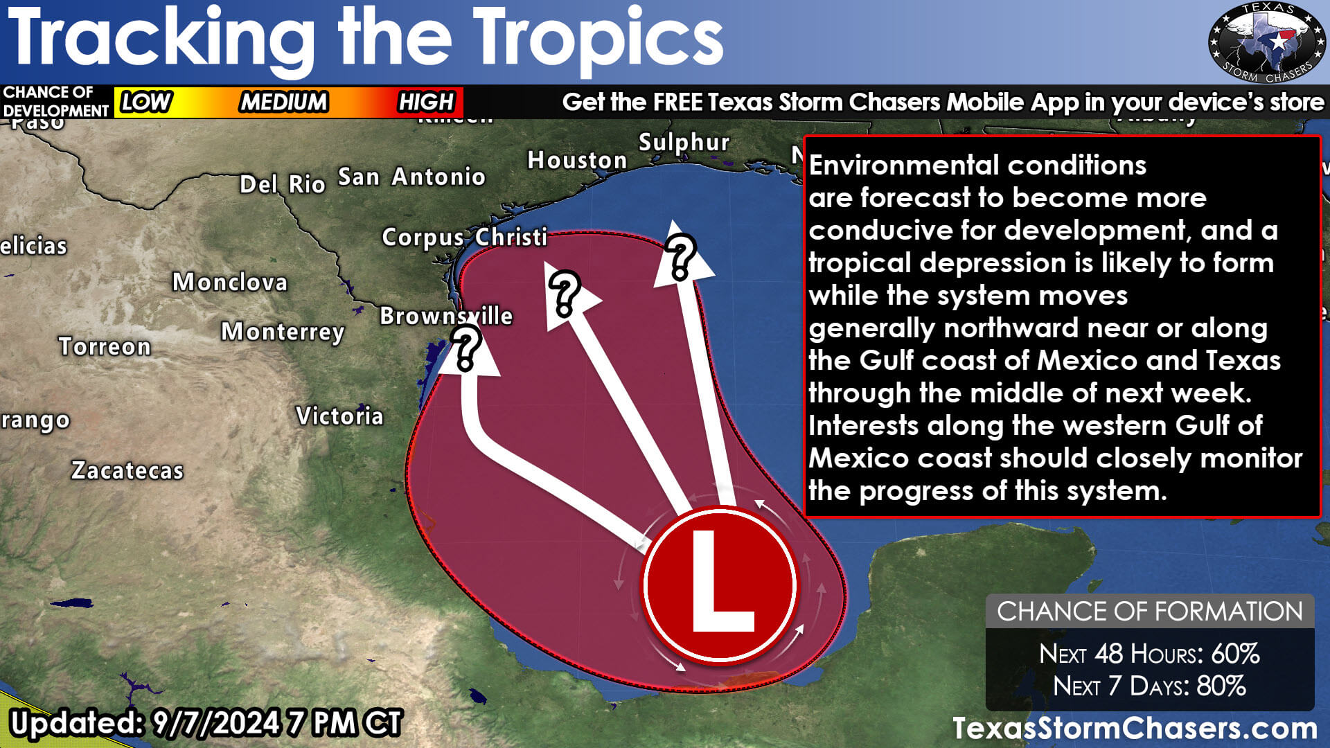
An area of low pressure has formed in the southwestern Gulf of Mexico or within the Bay of Campeche. This system is producing showers and thunderstorms. Conditions are favorable for the development of ‘tropical mischief.’ A tropical depression or storm may form over the next few days as the system slowly moves north. There is the potential for impactful weather along the Texas Gulf Coast beginning Monday in the Rio Grande Valley, up into the Coastal Bend, Coastal Plains, and Southeast Texas on Tuesday and Wednesday. If the system trends slower or farther east, that may change.
We anticipate the threat of heavy rainfall (possibly over five inches) for much of the Texas Gulf Coast over the upcoming five days. The recent arrival of a fall cool front, with much-welcomed drier air across Texas, complicates the forecast. Heavier rains could have trouble pushing inland from the coast, resulting in a sharp gradient between a little bit of rain and way too much rain. Inland from the coast, most of Texas may not see any rain. We can answer that question once a well-defined system forms and the forecast track is narrowed down.
Several days of onshore winds will promote at least a minor threat of coastal flooding for the Texas Gulf Coast. If we get a tropical storm, some danger of landfalling waterspouts and brief tornadoes may exist within outer bands. The track forecast ranges from a system riding the Texas Gulf Coast from the Rio Grande Valley into Southeast Texas to one that would keep the system ‘in the Gulf’ until landfall closer to the Sabine Pass in the Golden Triangle on the Upper Texas Coast (Far Southeast Texas). The ‘eastern’ solution would keep the most impactful weather in Far Southeast Texas and Louisiana, while western solutions would bring those impacts to more of the Texas Gulf Coast. If the system were to ‘ride’ the coast northeast from Mexico, it would impact nearly the entire Texas Gulf Coast over a few days (a slow-mover).
The key message is that all those on the Texas Gulf Coast should monitor the forecast over the next few days and check back for updates. Unsettled weather will likely result in heavy rain, gusty winds, and coastal flooding. There is the potential for more significant impacts, including flooding, stronger winds, and other hazards that can accompany a tropical cyclone. We’ll be able to be more specific with any effects and threats once the National Hurricane Center initiates advisories in the next day or two. Should the system attain tropical storm status, it will be named Francine.