Watches and Warnings
SPC Severe Thunderstorm Watch 249
WW 249 SEVERE TSTM NE SD 150100Z – 150800Z 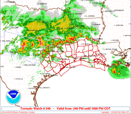
 URGENT - IMMEDIATE BROADCAST REQUESTED
Severe Thunderstorm Watch Number 249
NWS Storm Prediction Center Norman OK
800 PM CDT Wed May 14 2025 The NWS Storm Prediction Center has issued a * Severe Thunderstorm Watch for portions of East-Central and Northeast Nebraska Southeast South Dakota * Effective this Wednesday night and Thursday morning from 800 PM until 300 AM CDT. * Primary threats include... Scattered large hail and isolated very large hail events to 2 inches in diameter likely Scattered damaging winds likely with isolated significant gusts to 75 mph possible A tornado or two possible SUMMARY...Thunderstorms over central Nebraska will becoming
increasingly organized and track northeastward through the evening
and overnight period. Damaging wind gusts and large hail will be
through across the watch area. A tornado or two is also possible. The severe thunderstorm watch area is approximately along and 50
statute miles east and west of a line from 5 miles west northwest of
Mitchell SD to 25 miles west southwest of Grand Island NE. For a
complete depiction of the watch see the associated watch outline
update (WOUS64 KWNS WOU9). PRECAUTIONARY/PREPAREDNESS ACTIONS... REMEMBER...A Severe Thunderstorm Watch means conditions are
favorable for severe thunderstorms in and close to the watch area.
Persons in these areas should be on the lookout for threatening
weather conditions and listen for later statements and possible
warnings. Severe thunderstorms can and occasionally do produce
tornadoes. && OTHER WATCH INFORMATION...CONTINUE...WW 247...WW 248... AVIATION...A few severe thunderstorms with hail surface and aloft to
2 inches. Extreme turbulence and surface wind gusts to 65 knots. A
few cumulonimbi with maximum tops to 500. Mean storm motion vector
25035. ...Hart
SPC – No watches are valid as of Mon May 12 05:02:01 UTC 2025
No watches are valid as of Mon May 12 05:02:01 UTC 2025.
SPC – No watches are valid as of Sat May 10 21:05:02 UTC 2025
No watches are valid as of Sat May 10 21:05:02 UTC 2025.
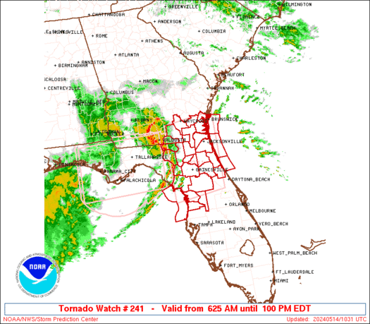
SPC Tornado Watch 244
WW 244 TORNADO AL FL GA CW 101510Z – 102200Z 
 URGENT - IMMEDIATE BROADCAST REQUESTED
Tornado Watch Number 244
NWS Storm Prediction Center Norman OK
1010 AM CDT Sat May 10 2025 The NWS Storm Prediction Center has issued a * Tornado Watch for portions of Far Southeast Alabama Central Florida Panhandle Southwest Georgia Coastal Waters * Effective this Saturday morning and afternoon from 1010 AM until 500 PM CDT. * Primary threats include... A couple tornadoes possible Isolated damaging wind gusts to 70 mph possible Isolated large hail events to 1 inch in diameter possible SUMMARY...Thunderstorm coverage is expected to increase across the
central FL Peninsula and adjacent areas this afternoon. The
environmental conditions are favorable for strong to severe storms
capable of damaging gusts and a few tornadoes. The tornado watch area is approximately along and 50 statute miles
east and west of a line from 30 miles west northwest of Albany GA to
30 miles south of Panama City FL. For a complete depiction of the
watch see the associated watch outline update (WOUS64 KWNS WOU4). PRECAUTIONARY/PREPAREDNESS ACTIONS... REMEMBER...A Tornado Watch means conditions are favorable for
tornadoes and severe thunderstorms in and close to the watch
area. Persons in these areas should be on the lookout for
threatening weather conditions and listen for later statements
and possible warnings. && AVIATION...Tornadoes and a few severe thunderstorms with hail
surface and aloft to 1 inch. Extreme turbulence and surface wind
gusts to 60 knots. A few cumulonimbi with maximum tops to 500. Mean
storm motion vector 24035. ...Mosier
SPC – No watches are valid as of Fri May 9 05:02:02 UTC 2025
No watches are valid as of Fri May 9 05:02:02 UTC 2025.
SPC Severe Thunderstorm Watch 243
WW 243 SEVERE TSTM TX CW 090010Z – 090500Z 
 URGENT - IMMEDIATE BROADCAST REQUESTED
Severe Thunderstorm Watch Number 243
NWS Storm Prediction Center Norman OK
710 PM CDT Thu May 8 2025 The NWS Storm Prediction Center has issued a * Severe Thunderstorm Watch for portions of South Texas Coastal Waters * Effective this Thursday night from 710 PM until Midnight CDT. * Primary threats include... Scattered damaging winds and isolated significant gusts to 75 mph possible Scattered large hail and isolated very large hail events to 2 inches in diameter possible SUMMARY...Clusters of strong to severe cellular thunderstorms will
likely grow upscale into a linear band of thunderstorms this
evening. Large hail (1 to 2 inches in diameter) and severe gusts
(60-75 mph) will be the primary threats with the more intense
storms. This activity is forecast to move east of the coast
tonight. The severe thunderstorm watch area is approximately along and 55
statute miles east and west of a line from 15 miles northwest of
Beeville TX to 105 miles south of Alice TX. For a complete depiction
of the watch see the associated watch outline update (WOUS64 KWNS
WOU3). PRECAUTIONARY/PREPAREDNESS ACTIONS... REMEMBER...A Severe Thunderstorm Watch means conditions are
favorable for severe thunderstorms in and close to the watch area.
Persons in these areas should be on the lookout for threatening
weather conditions and listen for later statements and possible
warnings. Severe thunderstorms can and occasionally do produce
tornadoes. && OTHER WATCH INFORMATION...CONTINUE...WW 238...WW 239...WW
240...WW 241...WW 242... AVIATION...A few severe thunderstorms with hail surface and aloft to
2 inches. Extreme turbulence and surface wind gusts to 65 knots. A
few cumulonimbi with maximum tops to 500. Mean storm motion vector
30035. ...Smith