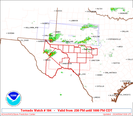
SPC Tornado Watch 185

WW 185 TORNADO IA MN WI 290030Z – 290700Z
WW 0185 Image

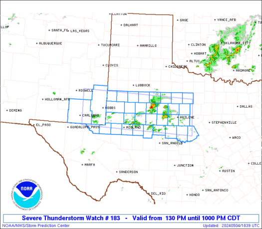
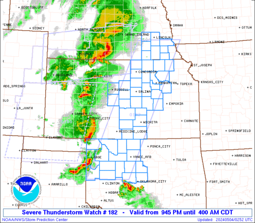
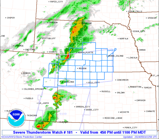
 URGENT - IMMEDIATE BROADCAST REQUESTED
Tornado Watch Number 185
NWS Storm Prediction Center Norman OK
730 PM CDT Mon Apr 28 2025 The NWS Storm Prediction Center has issued a * Tornado Watch for portions of Far Northeast Iowa Extreme Southeast Minnesota Western and Northern Wisconsin * Effective this Monday night and Tuesday morning from 730 PM until 200 AM CDT. * Primary threats include... A few tornadoes likely with a couple intense tornadoes possible Scattered damaging winds likely with isolated significant gusts to 75 mph possible Scattered large hail likely with isolated very large hail events to 2 inches in diameter possible SUMMARY...A broken line of thunderstorms will continue to move
quickly east-northeastward this evening and into the early overnight
hours. A few tornadoes and scattered severe/damaging should be the
main threats with this activity, but some large hail may also occur
with any embedded supercells. The tornado watch area is approximately along and 50 statute miles
east and west of a line from 55 miles north northeast of Wausau WI
to 45 miles south of La Crosse WI. For a complete depiction of the
watch see the associated watch outline update (WOUS64 KWNS WOU5). PRECAUTIONARY/PREPAREDNESS ACTIONS... REMEMBER...A Tornado Watch means conditions are favorable for
tornadoes and severe thunderstorms in and close to the watch
area. Persons in these areas should be on the lookout for
threatening weather conditions and listen for later statements
and possible warnings. && OTHER WATCH INFORMATION...CONTINUE...WW 180...WW 181...WW
182...WW 183...WW 184... AVIATION...Tornadoes and a few severe thunderstorms with hail
surface and aloft to 2 inches. Extreme turbulence and surface wind
gusts to 65 knots. A few cumulonimbi with maximum tops to 500. Mean
storm motion vector 26040. ...Gleason 

Read more

SPC Severe Thunderstorm Watch 184

WW 184 SEVERE TSTM IA NE SD 282300Z – 290400Z
WW 0184 Image

 URGENT - IMMEDIATE BROADCAST REQUESTED
Severe Thunderstorm Watch Number 184
NWS Storm Prediction Center Norman OK
600 PM CDT Mon Apr 28 2025 The NWS Storm Prediction Center has issued a * Severe Thunderstorm Watch for portions of Northwest Iowa Northeast Nebraska Southeast South Dakota * Effective this Monday evening from 600 PM until 1100 PM CDT. * Primary threats include... Scattered large hail and isolated very large hail events to 2 inches in diameter possible Scattered damaging wind gusts to 70 mph possible SUMMARY...Multiple supercells along and near a cold front should
pose a threat for mainly large hail up to 1-2 inches in diameter
through the evening. Occasional severe/damaging winds may also
occur. The severe thunderstorm watch area is approximately along and 45
statute miles north and south of a line from 45 miles west southwest
of Yankton SD to 20 miles south of Spencer IA. For a complete
depiction of the watch see the associated watch outline update
(WOUS64 KWNS WOU4). PRECAUTIONARY/PREPAREDNESS ACTIONS... REMEMBER...A Severe Thunderstorm Watch means conditions are
favorable for severe thunderstorms in and close to the watch area.
Persons in these areas should be on the lookout for threatening
weather conditions and listen for later statements and possible
warnings. Severe thunderstorms can and occasionally do produce
tornadoes. && OTHER WATCH INFORMATION...CONTINUE...WW 180...WW 181...WW
182...WW 183... AVIATION...A few severe thunderstorms with hail surface and aloft to
2 inches. Extreme turbulence and surface wind gusts to 60 knots. A
few cumulonimbi with maximum tops to 500. Mean storm motion vector
26040. ...Gleason 

Read more

SPC Tornado Watch 183

WW 183 TORNADO IA KS MO NE 282200Z – 290500Z
WW 0183 Image

 URGENT - IMMEDIATE BROADCAST REQUESTED
Tornado Watch Number 183
NWS Storm Prediction Center Norman OK
500 PM CDT Mon Apr 28 2025 The NWS Storm Prediction Center has issued a * Tornado Watch for portions of Southwest into Central Iowa Northeast Kansas Northwest Missouri Far Southeast Nebraska * Effective this Monday afternoon from 500 PM until Midnight CDT. * Primary threats include... A few tornadoes likely with a couple intense tornadoes possible Scattered large hail and isolated very large hail events to 3 inches in diameter likely Scattered damaging winds likely with isolated significant gusts to 75 mph possible SUMMARY...Supercells are expected to continue developing this
evening while posing a threat for very large hail up to 2-3 inches
in diameter. A few tornadoes also appear likely, with a couple of
strong tornadoes possible with any sustained supercell. Scattered
severe/damaging winds with peak gusts to 65-75 mph may also occur. The tornado watch area is approximately along and 55 statute miles
east and west of a line from 45 miles north northwest of Des Moines
IA to 35 miles south southeast of Manhattan KS. For a complete
depiction of the watch see the associated watch outline update
(WOUS64 KWNS WOU3). PRECAUTIONARY/PREPAREDNESS ACTIONS... REMEMBER...A Tornado Watch means conditions are favorable for
tornadoes and severe thunderstorms in and close to the watch
area. Persons in these areas should be on the lookout for
threatening weather conditions and listen for later statements
and possible warnings. && OTHER WATCH INFORMATION...CONTINUE...WW 180...WW 181...WW 182... AVIATION...Tornadoes and a few severe thunderstorms with hail
surface and aloft to 3 inches. Extreme turbulence and surface wind
gusts to 65 knots. A few cumulonimbi with maximum tops to 500. Mean
storm motion vector 24035. ...Gleason 

Read more

SPC Tornado Watch 182

WW 182 TORNADO OK TX 282100Z – 290400Z
WW 0182 Image

 URGENT - IMMEDIATE BROADCAST REQUESTED
Tornado Watch Number 182
NWS Storm Prediction Center Norman OK
400 PM CDT Mon Apr 28 2025 The NWS Storm Prediction Center has issued a * Tornado Watch for portions of Western Oklahoma West-Central Texas * Effective this Monday afternoon and evening from 400 PM until 1100 PM CDT. * Primary threats include... A couple tornadoes possible Scattered large hail and isolated very large hail events to 3 inches in diameter likely Scattered damaging winds likely with isolated significant gusts to 75 mph possible SUMMARY...Thunderstorms will intensify rapidly this afternoon in a
very unstable environment. Very large hail and damaging winds are
the primary threat. However, there is some concern for a few
tornadoes during the early evening. The tornado watch area is approximately along and 65 statute miles
east and west of a line from 60 miles south southeast of Big Spring
TX to 40 miles north of Oklahoma City OK. For a complete depiction
of the watch see the associated watch outline update (WOUS64 KWNS
WOU2). PRECAUTIONARY/PREPAREDNESS ACTIONS... REMEMBER...A Tornado Watch means conditions are favorable for
tornadoes and severe thunderstorms in and close to the watch
area. Persons in these areas should be on the lookout for
threatening weather conditions and listen for later statements
and possible warnings. && OTHER WATCH INFORMATION...CONTINUE...WW 180...WW 181... AVIATION...Tornadoes and a few severe thunderstorms with hail
surface and aloft to 3 inches. Extreme turbulence and surface wind
gusts to 65 knots. A few cumulonimbi with maximum tops to 500. Mean
storm motion vector 24035. ...Hart 

Read more

SPC Tornado Watch 181

WW 181 TORNADO IA MN WI 282025Z – 290400Z
WW 0181 Image

 URGENT - IMMEDIATE BROADCAST REQUESTED
Tornado Watch Number 181
NWS Storm Prediction Center Norman OK
325 PM CDT Mon Apr 28 2025 The NWS Storm Prediction Center has issued a * Tornado Watch for portions of Northern Iowa Central and Southeast Minnesota Western Wisconsin * Effective this Monday afternoon and evening from 325 PM until 1100 PM CDT. * Primary threats include... A few tornadoes and a couple intense tornadoes likely Widespread large hail and scattered very large hail events to 3 inches in diameter likely Scattered damaging winds likely with isolated significant gusts to 75 mph possible SUMMARY...A line of intense thunderstorms over western Minnesota
will track northeastward across the watch area through the evening. Very large hail and a few tornadoes are the primary concerns. Strong tornadoes are also possible. The tornado watch area is approximately along and 65 statute miles
east and west of a line from 95 miles north northeast of Minneapolis
MN to 20 miles southeast of Fort Dodge IA. For a complete depiction
of the watch see the associated watch outline update (WOUS64 KWNS
WOU1). PRECAUTIONARY/PREPAREDNESS ACTIONS... REMEMBER...A Tornado Watch means conditions are favorable for
tornadoes and severe thunderstorms in and close to the watch
area. Persons in these areas should be on the lookout for
threatening weather conditions and listen for later statements
and possible warnings. && OTHER WATCH INFORMATION...CONTINUE...WW 180... AVIATION...Tornadoes and a few severe thunderstorms with hail
surface and aloft to 3 inches. Extreme turbulence and surface wind
gusts to 65 knots. A few cumulonimbi with maximum tops to 500. Mean
storm motion vector 24035. ...Hart 

Read more