SPC Severe Thunderstorm Watch 138

WW 138 SEVERE TSTM KY OH PA VA WV 141925Z – 150300Z
WW 0138 Image

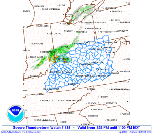
 URGENT - IMMEDIATE BROADCAST REQUESTED
Severe Thunderstorm Watch Number 138
NWS Storm Prediction Center Norman OK
325 PM EDT Mon Apr 14 2025 The NWS Storm Prediction Center has issued a * Severe Thunderstorm Watch for portions of Central and Eastern Kentucky Southern Ohio Far Southwestern Pennsylvania Southwestern Virginia West Virginia * Effective this Monday afternoon and evening from 325 PM until 1100 PM EDT. * Primary threats include... Scattered damaging wind gusts to 70 mph likely Scattered large hail and isolated very large hail events to 2 inches in diameter possible A tornado or two possible SUMMARY...Thunderstorms coverage is expected to increase over the
next few hours along and ahead of a cold front pushing eastward
across the region. Environmental conditions support strong to severe
storms. An initially cellular mode will favor large hail and
damaging gusts before a transition to a more linear storm mode
favors primarily damaging gusts. The severe thunderstorm watch area is approximately along and 80
statute miles north and south of a line from 30 miles west of
Lexington KY to 60 miles north northeast of White Sulphur Springs
WV. For a complete depiction of the watch see the associated watch
outline update (WOUS64 KWNS WOU8). PRECAUTIONARY/PREPAREDNESS ACTIONS... REMEMBER...A Severe Thunderstorm Watch means conditions are
favorable for severe thunderstorms in and close to the watch area.
Persons in these areas should be on the lookout for threatening
weather conditions and listen for later statements and possible
warnings. Severe thunderstorms can and occasionally do produce
tornadoes. && AVIATION...A few severe thunderstorms with hail surface and aloft to
2 inches. Extreme turbulence and surface wind gusts to 60 knots. A
few cumulonimbi with maximum tops to 500. Mean storm motion vector
24040. ...Mosier 

Read more

SPC Severe Thunderstorm Watch 137

WW 137 SEVERE TSTM GA NC SC TN 102100Z – 110400Z
WW 0137 Image

 URGENT - IMMEDIATE BROADCAST REQUESTED
Severe Thunderstorm Watch Number 137
NWS Storm Prediction Center Norman OK
500 PM EDT Thu Apr 10 2025 The NWS Storm Prediction Center has issued a * Severe Thunderstorm Watch for portions of Northern and Central Georgia Far Southwest North Carolina Extreme Western South Carolina Eastern Tennessee * Effective this Thursday afternoon from 500 PM until Midnight EDT. * Primary threats include... Scattered large hail and isolated very large hail events to 2 inches in diameter possible Scattered damaging wind gusts to 70 mph possible SUMMARY...Scattered supercells should continue to pose some threat
for severe hail up to 1-1.75 inches in diameter through the rest of
the afternoon and into the evening. Damaging winds may also occur
with any clusters that can form, before convection eventually
weakens with eastward extent. The severe thunderstorm watch area is approximately along and 55
statute miles east and west of a line from 45 miles north northwest
of Knoxville TN to 30 miles south southeast of Atlanta GA. For a
complete depiction of the watch see the associated watch outline
update (WOUS64 KWNS WOU7). PRECAUTIONARY/PREPAREDNESS ACTIONS... REMEMBER...A Severe Thunderstorm Watch means conditions are
favorable for severe thunderstorms in and close to the watch area.
Persons in these areas should be on the lookout for threatening
weather conditions and listen for later statements and possible
warnings. Severe thunderstorms can and occasionally do produce
tornadoes. && OTHER WATCH INFORMATION...CONTINUE...WW 135...WW 136... AVIATION...A few severe thunderstorms with hail surface and aloft to
2 inches. Extreme turbulence and surface wind gusts to 60 knots. A
few cumulonimbi with maximum tops to 500. Mean storm motion vector
31035. ...Gleason 

Read more

SPC Severe Thunderstorm Watch 136

WW 136 SEVERE TSTM AL AR MS TN 102035Z – 110400Z
WW 0136 Image

 URGENT - IMMEDIATE BROADCAST REQUESTED
Severe Thunderstorm Watch Number 136
NWS Storm Prediction Center Norman OK
335 PM CDT Thu Apr 10 2025 The NWS Storm Prediction Center has issued a * Severe Thunderstorm Watch for portions of Northern and Central Alabama Far Eastern Arkansas Northern and Central Mississippi Far Southern Middle Tennessee * Effective this Thursday afternoon and evening from 335 PM until 1100 PM CDT. * Primary threats include... Scattered damaging winds likely with isolated significant gusts to 75 mph possible Scattered large hail likely with isolated very large hail events to 2 inches in diameter possible SUMMARY...Robust thunderstorms will continue to develop this
afternoon and spread southeastward through the evening. Supercells
will pose a threat for large hail generally ranging from 1-2 inches
in diameter. Scattered severe/damaging winds, with peak gusts up to
65-75 mph, should also occur as clusters form later this afternoon
and evening. The severe thunderstorm watch area is approximately along and 70
statute miles north and south of a line from 55 miles north
northwest of Greenwood MS to 25 miles northeast of Anniston AL. For
a complete depiction of the watch see the associated watch outline
update (WOUS64 KWNS WOU6). PRECAUTIONARY/PREPAREDNESS ACTIONS... REMEMBER...A Severe Thunderstorm Watch means conditions are
favorable for severe thunderstorms in and close to the watch area.
Persons in these areas should be on the lookout for threatening
weather conditions and listen for later statements and possible
warnings. Severe thunderstorms can and occasionally do produce
tornadoes. && OTHER WATCH INFORMATION...CONTINUE...WW 135... AVIATION...A few severe thunderstorms with hail surface and aloft to
2 inches. Extreme turbulence and surface wind gusts to 65 knots. A
few cumulonimbi with maximum tops to 500. Mean storm motion vector
31035. ...Gleason 

Read more

SPC Severe Thunderstorm Watch 135

WW 135 SEVERE TSTM AR IL KY MO TN 101920Z – 110200Z
WW 0135 Image

 URGENT - IMMEDIATE BROADCAST REQUESTED
Severe Thunderstorm Watch Number 135
NWS Storm Prediction Center Norman OK
220 PM CDT Thu Apr 10 2025 The NWS Storm Prediction Center has issued a * Severe Thunderstorm Watch for portions of Far Northeast Arkansas Far Southern Illinois Western and South-Central Kentucky Far Southeast Missouri Western and Middle Tennessee * Effective this Thursday afternoon and evening from 220 PM until 900 PM CDT. * Primary threats include... Scattered damaging wind gusts to 70 mph likely Scattered large hail and isolated very large hail events to 2 inches in diameter possible SUMMARY...Thunderstorms should gradually evolve east-southeastward
this afternoon and evening while posing a threat for mainly
scattered damaging winds. Peak gusts could reach up to 60-70 mph.
Occasional severe hail generally ranging from 1-1.75 inches in
diameter may also occur with any sustained supercell. The severe thunderstorm watch area is approximately along and 65
statute miles north and south of a line from 50 miles west northwest
of Dyersburg TN to 70 miles east of Nashville TN. For a complete
depiction of the watch see the associated watch outline update
(WOUS64 KWNS WOU5). PRECAUTIONARY/PREPAREDNESS ACTIONS... REMEMBER...A Severe Thunderstorm Watch means conditions are
favorable for severe thunderstorms in and close to the watch area.
Persons in these areas should be on the lookout for threatening
weather conditions and listen for later statements and possible
warnings. Severe thunderstorms can and occasionally do produce
tornadoes. && AVIATION...A few severe thunderstorms with hail surface and aloft to
2 inches. Extreme turbulence and surface wind gusts to 60 knots. A
few cumulonimbi with maximum tops to 450. Mean storm motion vector
31035. ...Gleason 

Read more