Watches and Warnings
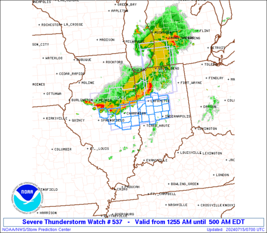
SPC Severe Thunderstorm Watch 537
WW 537 SEVERE TSTM IL IN 150455Z – 150900Z 
 URGENT - IMMEDIATE BROADCAST REQUESTED
Severe Thunderstorm Watch Number 537
NWS Storm Prediction Center Norman OK
1255 AM EDT Mon Jul 15 2024 The NWS Storm Prediction Center has issued a * Severe Thunderstorm Watch for portions of Central Illinois Central Indiana * Effective this Monday morning from 1255 AM until 500 AM EDT. * Primary threats include... Scattered damaging wind gusts to 70 mph likely A tornado or two possible SUMMARY...A cluster of thunderstorms should continue to move
southeastward through the early morning hours while posing some
threat for mainly severe/damaging winds up to 60-70 mph. The severe thunderstorm watch area is approximately along and 30
statute miles north and south of a line from 10 miles west of
Decatur IL to 35 miles northeast of Indianapolis IN. For a complete
depiction of the watch see the associated watch outline update
(WOUS64 KWNS WOU7). PRECAUTIONARY/PREPAREDNESS ACTIONS... REMEMBER...A Severe Thunderstorm Watch means conditions are
favorable for severe thunderstorms in and close to the watch area.
Persons in these areas should be on the lookout for threatening
weather conditions and listen for later statements and possible
warnings. Severe thunderstorms can and occasionally do produce
tornadoes. && OTHER WATCH INFORMATION...CONTINUE...WW 533...WW 534...WW
535...WW 536... AVIATION...A few severe thunderstorms with hail surface and aloft to
1 inch. Extreme turbulence and surface wind gusts to 60 knots. A few
cumulonimbi with maximum tops to 500. Mean storm motion vector
30035. ...Gleason
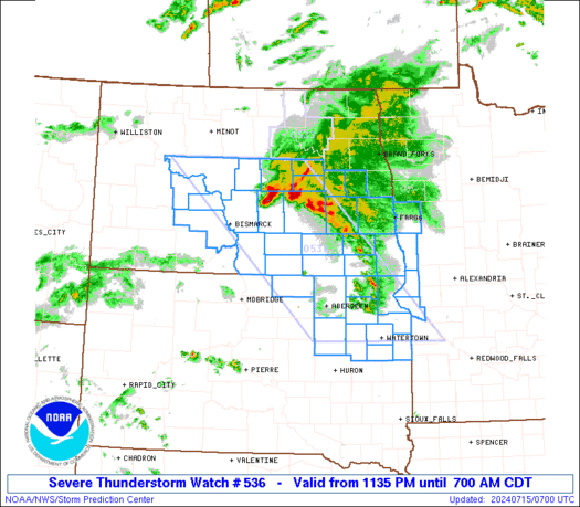
SPC Severe Thunderstorm Watch 536
WW 536 SEVERE TSTM MN ND SD 150435Z – 151200Z 
 URGENT - IMMEDIATE BROADCAST REQUESTED
Severe Thunderstorm Watch Number 536
NWS Storm Prediction Center Norman OK
1135 PM CDT Sun Jul 14 2024 The NWS Storm Prediction Center has issued a * Severe Thunderstorm Watch for portions of Far West-Central Minnesota Central and Eastern North Dakota Northeast South Dakota * Effective this Sunday night and Monday morning from 1135 PM until 700 AM CDT. * Primary threats include... Scattered large hail likely with isolated very large hail events to 2.5 inches in diameter possible Scattered damaging winds and isolated significant gusts to 75 mph possible SUMMARY...Thunderstorms will spread southeastward through the early
morning hours while posing a threat for large hail up to 1.5-2.5
inches in diameter, along with severe/damaging winds around 60-75
mph. The severe thunderstorm watch area is approximately along and 75
statute miles east and west of a line from 40 miles east northeast
of Garrison ND to 5 miles southwest of Watertown SD. For a complete
depiction of the watch see the associated watch outline update
(WOUS64 KWNS WOU6). PRECAUTIONARY/PREPAREDNESS ACTIONS... REMEMBER...A Severe Thunderstorm Watch means conditions are
favorable for severe thunderstorms in and close to the watch area.
Persons in these areas should be on the lookout for threatening
weather conditions and listen for later statements and possible
warnings. Severe thunderstorms can and occasionally do produce
tornadoes. && OTHER WATCH INFORMATION...CONTINUE...WW 533...WW 534...WW 535... AVIATION...A few severe thunderstorms with hail surface and aloft to
2.5 inches. Extreme turbulence and surface wind gusts to 65 knots. A
few cumulonimbi with maximum tops to 500. Mean storm motion vector
30035. ...Gleason
SPC Severe Thunderstorm Watch 535
WW 535 SEVERE TSTM IN MI LM 150345Z – 150900Z 
 URGENT - IMMEDIATE BROADCAST REQUESTED
Severe Thunderstorm Watch Number 535
NWS Storm Prediction Center Norman OK
1145 PM EDT Sun Jul 14 2024 The NWS Storm Prediction Center has issued a * Severe Thunderstorm Watch for portions of Northern Indiana Southwest Lower Michigan Lake Michigan * Effective this Sunday night and Monday morning from 1145 PM until 500 AM EDT. * Primary threats include... Scattered damaging wind gusts to 70 mph likely Isolated large hail events to 1 inch in diameter possible A tornado or two possible SUMMARY...A small bowing complex of thunderstorms should pose some
threat for damaging winds as it moves east-southeastward through the
early morning hours. Peak gusts may reach up to 60-70 mph in the
most intense portion of the bow. The severe thunderstorm watch area is approximately along and 40
statute miles east and west of a line from 30 miles north northeast
of Benton Harbor MI to 75 miles south of South Bend IN. For a
complete depiction of the watch see the associated watch outline
update (WOUS64 KWNS WOU5). PRECAUTIONARY/PREPAREDNESS ACTIONS... REMEMBER...A Severe Thunderstorm Watch means conditions are
favorable for severe thunderstorms in and close to the watch area.
Persons in these areas should be on the lookout for threatening
weather conditions and listen for later statements and possible
warnings. Severe thunderstorms can and occasionally do produce
tornadoes. && OTHER WATCH INFORMATION...CONTINUE...WW 533...WW 534... AVIATION...A few severe thunderstorms with hail surface and aloft to
1 inch. Extreme turbulence and surface wind gusts to 60 knots. A few
cumulonimbi with maximum tops to 500. Mean storm motion vector
28035. ...Gleason
SPC Severe Thunderstorm Watch 534
WW 534 SEVERE TSTM IA IL IN WI LM 142255Z – 150600Z 
 URGENT - IMMEDIATE BROADCAST REQUESTED
Severe Thunderstorm Watch Number 534
NWS Storm Prediction Center Norman OK
555 PM CDT Sun Jul 14 2024 The NWS Storm Prediction Center has issued a * Severe Thunderstorm Watch for portions of Northern and Eastern Iowa Northern Illinois Far Northwest Indiana Southern Wisconsin Lake Michigan * Effective this Sunday afternoon and Monday morning from 555 PM until 100 AM CDT. * Primary threats include... Scattered damaging wind gusts to 70 mph likely Isolated very large hail events to 2 inches in diameter possible A tornado or two possible SUMMARY...Thunderstorms are expected to continue increasing in
coverage and intensity this evening. Isolated large hail generally
1-1.75 inches in diameter may occur with the initially more cellular
activity. With time, a bowing cluster of thunderstorms should pose a
greater threat for severe/damaging winds up to around 60-70 mph. A
landspout tornado or two also appears possible. The severe thunderstorm watch area is approximately along and 60
statute miles north and south of a line from 45 miles south
southwest of Mason City IA to 55 miles south of Racine WI. For a
complete depiction of the watch see the associated watch outline
update (WOUS64 KWNS WOU4). PRECAUTIONARY/PREPAREDNESS ACTIONS... REMEMBER...A Severe Thunderstorm Watch means conditions are
favorable for severe thunderstorms in and close to the watch area.
Persons in these areas should be on the lookout for threatening
weather conditions and listen for later statements and possible
warnings. Severe thunderstorms can and occasionally do produce
tornadoes. && OTHER WATCH INFORMATION...CONTINUE...WW 533... AVIATION...A few severe thunderstorms with hail surface and aloft to
2 inches. Extreme turbulence and surface wind gusts to 60 knots. A
few cumulonimbi with maximum tops to 500. Mean storm motion vector
28030. ...Gleason
SPC Severe Thunderstorm Watch 533
WW 533 SEVERE TSTM MT ND 142200Z – 150500Z 
 URGENT - IMMEDIATE BROADCAST REQUESTED
Severe Thunderstorm Watch Number 533
NWS Storm Prediction Center Norman OK
500 PM CDT Sun Jul 14 2024 The NWS Storm Prediction Center has issued a * Severe Thunderstorm Watch for portions of Northeast Montana Western and Northern North Dakota * Effective this Sunday afternoon from 500 PM until Midnight CDT. * Primary threats include... Scattered large hail likely with isolated very large hail events to 2.5 inches in diameter possible Scattered damaging winds and isolated significant gusts to 75 mph possible A tornado or two possible SUMMARY...Supercell thunderstorms are expected to develop this
afternoon and evening and move slowly east-southeastward. The most
intense thunderstorms should be capable of producing large to very
large hail around 1.5-2.5 inches in diameter. The potential for
severe/damaging winds is more uncertain. But, if activity can grow
into a bowing cluster later this evening, then peak wind speeds may
reach 65-75 mph. The severe thunderstorm watch area is approximately along and 55
statute miles north and south of a line from 5 miles southwest of
Glasgow MT to 95 miles east of Minot ND. For a complete depiction of
the watch see the associated watch outline update (WOUS64 KWNS
WOU3). PRECAUTIONARY/PREPAREDNESS ACTIONS... REMEMBER...A Severe Thunderstorm Watch means conditions are
favorable for severe thunderstorms in and close to the watch area.
Persons in these areas should be on the lookout for threatening
weather conditions and listen for later statements and possible
warnings. Severe thunderstorms can and occasionally do produce
tornadoes. && AVIATION...A few severe thunderstorms with hail surface and aloft to
2.5 inches. Extreme turbulence and surface wind gusts to 65 knots. A
few cumulonimbi with maximum tops to 500. Mean storm motion vector
30025. ...Gleason