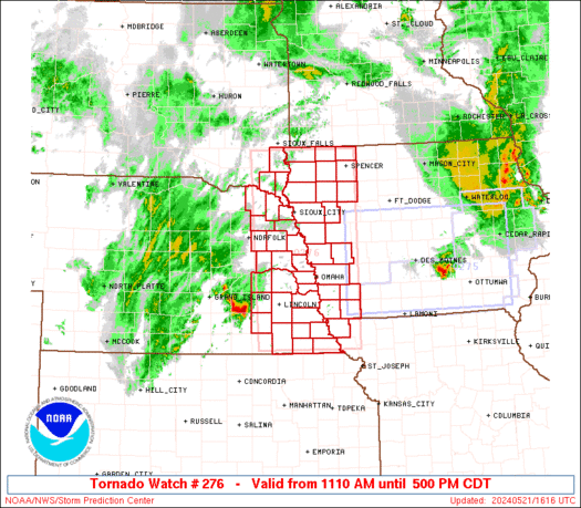
Watches and Warnings
SPC Severe Thunderstorm Watch 281
WW 281 SEVERE TSTM AR LA MS 172200Z – 180300Z 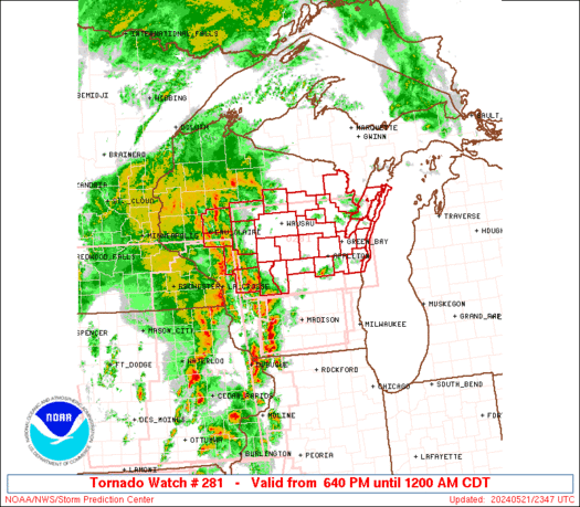
 URGENT - IMMEDIATE BROADCAST REQUESTED
Severe Thunderstorm Watch Number 281
NWS Storm Prediction Center Norman OK
500 PM CDT Sat May 17 2025 The NWS Storm Prediction Center has issued a * Severe Thunderstorm Watch for portions of Southeast Arkansas Northeast Louisiana West-Central Mississippi * Effective this Saturday afternoon and evening from 500 PM until 1000 PM CDT. * Primary threats include... Scattered large hail and isolated very large hail events to 2 inches in diameter possible Isolated damaging wind gusts to 70 mph possible SUMMARY...Ongoing supercell thunderstorms should persist for several
more hours this afternoon and evening while posing a threat for
mainly 1-2 inch diameter hail. Isolated damaging winds may also
occur. The severe thunderstorm watch area is approximately along and 45
statute miles north and south of a line from 40 miles north of
Monroe LA to 30 miles south of Greenwood MS. For a complete
depiction of the watch see the associated watch outline update
(WOUS64 KWNS WOU1). PRECAUTIONARY/PREPAREDNESS ACTIONS... REMEMBER...A Severe Thunderstorm Watch means conditions are
favorable for severe thunderstorms in and close to the watch area.
Persons in these areas should be on the lookout for threatening
weather conditions and listen for later statements and possible
warnings. Severe thunderstorms can and occasionally do produce
tornadoes. && OTHER WATCH INFORMATION...CONTINUE...WW 277...WW 278...WW
279...WW 280... AVIATION...A few severe thunderstorms with hail surface and aloft to
2 inches. Extreme turbulence and surface wind gusts to 60 knots. A
few cumulonimbi with maximum tops to 550. Mean storm motion vector
26025. ...Gleason
SPC Severe Thunderstorm Watch 280
WW 280 SEVERE TSTM TX 171955Z – 180300Z 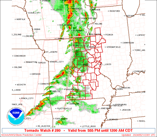
 URGENT - IMMEDIATE BROADCAST REQUESTED
Severe Thunderstorm Watch Number 280
NWS Storm Prediction Center Norman OK
255 PM CDT Sat May 17 2025 The NWS Storm Prediction Center has issued a * Severe Thunderstorm Watch for portions of West-Central Texas * Effective this Saturday afternoon and evening from 255 PM until 1000 PM CDT. * Primary threats include... Scattered large hail and isolated very large hail events to 3 inches in diameter likely Scattered damaging wind gusts to 70 mph likely SUMMARY...Thunderstorms will affect the watch area through the
afternoon and early evening. Very unstable conditions will promote
a risk of large hail and damaging winds in the strongest storms. The severe thunderstorm watch area is approximately along and 75
statute miles east and west of a line from 10 miles southwest of Del
Rio TX to 45 miles northwest of Temple TX. For a complete depiction
of the watch see the associated watch outline update (WOUS64 KWNS
WOU0). PRECAUTIONARY/PREPAREDNESS ACTIONS... REMEMBER...A Severe Thunderstorm Watch means conditions are
favorable for severe thunderstorms in and close to the watch area.
Persons in these areas should be on the lookout for threatening
weather conditions and listen for later statements and possible
warnings. Severe thunderstorms can and occasionally do produce
tornadoes. && OTHER WATCH INFORMATION...CONTINUE...WW 277...WW 278...WW 279... AVIATION...A few severe thunderstorms with hail surface and aloft to
3 inches. Extreme turbulence and surface wind gusts to 60 knots. A
few cumulonimbi with maximum tops to 500. Mean storm motion vector
25025. ...Hart
SPC Severe Thunderstorm Watch 278
WW 278 SEVERE TSTM TX 171930Z – 180300Z 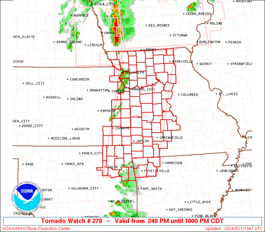
 URGENT - IMMEDIATE BROADCAST REQUESTED
Severe Thunderstorm Watch Number 278
NWS Storm Prediction Center Norman OK
230 PM CDT Sat May 17 2025 The NWS Storm Prediction Center has issued a * Severe Thunderstorm Watch for portions of Northwest and North-Central Texas * Effective this Saturday afternoon and evening from 230 PM until 1000 PM CDT. * Primary threats include... Scattered large hail and isolated very large hail events to 4 inches in diameter likely Scattered damaging winds likely with isolated significant gusts to 80 mph possible A tornado or two possible SUMMARY...Thunderstorms will rapidly intensify this afternoon.
Supercells capable of very large hail and damaging winds will be a
concern through the early evening. A tornado or two is also
possible. The severe thunderstorm watch area is approximately along and 85
statute miles east and west of a line from 60 miles north of Fort
Worth TX to 5 miles south of Waco TX. For a complete depiction of
the watch see the associated watch outline update (WOUS64 KWNS
WOU8). PRECAUTIONARY/PREPAREDNESS ACTIONS... REMEMBER...A Severe Thunderstorm Watch means conditions are
favorable for severe thunderstorms in and close to the watch area.
Persons in these areas should be on the lookout for threatening
weather conditions and listen for later statements and possible
warnings. Severe thunderstorms can and occasionally do produce
tornadoes. && OTHER WATCH INFORMATION...CONTINUE...WW 277... AVIATION...A few severe thunderstorms with hail surface and aloft to
4 inches. Extreme turbulence and surface wind gusts to 70 knots. A
few cumulonimbi with maximum tops to 600. Mean storm motion vector
27030. ...Hart
SPC Severe Thunderstorm Watch 277
WW 277 SEVERE TSTM NH NY VT LO 171635Z – 180000Z 
 URGENT - IMMEDIATE BROADCAST REQUESTED
Severe Thunderstorm Watch Number 277
NWS Storm Prediction Center Norman OK
1235 PM EDT Sat May 17 2025 The NWS Storm Prediction Center has issued a * Severe Thunderstorm Watch for portions of Western New Hampshire Central and Northern New York Vermont Lake Ontario * Effective this Saturday afternoon and evening from 1235 PM until 800 PM EDT. * Primary threats include... Scattered damaging wind gusts to 65 mph possible Scattered large hail events to 1.5 inches in diameter possible A tornado or two possible SUMMARY...Scattered strong to severe thunderstorms will increase in
coverage through the afternoon. Locally damaging winds are the main
concern, but the strongest cells could also produce large hail and
perhaps a tornado. The severe thunderstorm watch area is approximately along and 75
statute miles north and south of a line from 30 miles east southeast
of Montpelier VT to 5 miles south of Rochester NY. For a complete
depiction of the watch see the associated watch outline update
(WOUS64 KWNS WOU7). PRECAUTIONARY/PREPAREDNESS ACTIONS... REMEMBER...A Severe Thunderstorm Watch means conditions are
favorable for severe thunderstorms in and close to the watch area.
Persons in these areas should be on the lookout for threatening
weather conditions and listen for later statements and possible
warnings. Severe thunderstorms can and occasionally do produce
tornadoes. && AVIATION...A few severe thunderstorms with hail surface and aloft to
1.5 inches. Extreme turbulence and surface wind gusts to 55 knots. A
few cumulonimbi with maximum tops to 500. Mean storm motion vector
26030. ...Hart
SPC – No watches are valid as of Sat May 17 13:01:02 UTC 2025
No watches are valid as of Sat May 17 13:01:02 UTC 2025.