Watches and Warnings
SPC Tornado Watch 197
WW 197 TORNADO IN KY OH 072200Z – 080500Z 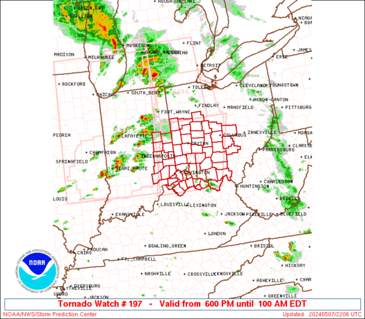
 URGENT - IMMEDIATE BROADCAST REQUESTED
Tornado Watch Number 197
NWS Storm Prediction Center Norman OK
600 PM EDT Tue May 7 2024 The NWS Storm Prediction Center has issued a * Tornado Watch for portions of Eastern Indiana Northern Kentucky Western Ohio * Effective this Tuesday night and Wednesday morning from 600 PM until 100 AM EDT. * Primary threats include... A few tornadoes and a couple intense tornadoes likely Scattered large hail and isolated very large hail events to 2 inches in diameter likely Scattered damaging wind gusts to 70 mph likely SUMMARY...Scattered intense thunderstorms over central Indiana will
track eastward through the evening, affecting the watch area. Large
hail, damaging winds, and a few tornadoes are possible with this
activity. The tornado watch area is approximately along and 70 statute miles
east and west of a line from 55 miles north northeast of Dayton OH
to 45 miles south of Cincinnati OH. For a complete depiction of the
watch see the associated watch outline update (WOUS64 KWNS WOU7). PRECAUTIONARY/PREPAREDNESS ACTIONS... REMEMBER...A Tornado Watch means conditions are favorable for
tornadoes and severe thunderstorms in and close to the watch
area. Persons in these areas should be on the lookout for
threatening weather conditions and listen for later statements
and possible warnings. && OTHER WATCH INFORMATION...CONTINUE...WW 195...WW 196... AVIATION...Tornadoes and a few severe thunderstorms with hail
surface and aloft to 2 inches. Extreme turbulence and surface wind
gusts to 60 knots. A few cumulonimbi with maximum tops to 500. Mean
storm motion vector 25035. ...Hart
SPC Tornado Watch 196
WW 196 TORNADO IN MI OH LE 072055Z – 080300Z 
 URGENT - IMMEDIATE BROADCAST REQUESTED
Tornado Watch Number 196
NWS Storm Prediction Center Norman OK
455 PM EDT Tue May 7 2024 The NWS Storm Prediction Center has issued a * Tornado Watch for portions of Northeast Indiana Southern Lower Michigan Northwest Ohio Lake Erie * Effective this Tuesday afternoon and evening from 455 PM until 1100 PM EDT. * Primary threats include... A couple tornadoes possible Scattered large hail and isolated very large hail events to 2 inches in diameter possible Scattered damaging wind gusts to 70 mph possible SUMMARY...Scattered thunderstorms will likely move into the Watch
area through the late afternoon and evening. The more intense
storms, including the possibility for several supercells, will pose
a risk for large hail, severe gusts, and tornadoes. The tornado watch area is approximately along and 50 statute miles
east and west of a line from 25 miles north northeast of Lansing MI
to 40 miles southwest of Findlay OH. For a complete depiction of the
watch see the associated watch outline update (WOUS64 KWNS WOU6). PRECAUTIONARY/PREPAREDNESS ACTIONS... REMEMBER...A Tornado Watch means conditions are favorable for
tornadoes and severe thunderstorms in and close to the watch
area. Persons in these areas should be on the lookout for
threatening weather conditions and listen for later statements
and possible warnings. && OTHER WATCH INFORMATION...CONTINUE...WW 195... AVIATION...Tornadoes and a few severe thunderstorms with hail
surface and aloft to 2 inches. Extreme turbulence and surface wind
gusts to 60 knots. A few cumulonimbi with maximum tops to 500. Mean
storm motion vector 24035. ...Smith
SPC Tornado Watch 195
WW 195 TORNADO IL IN MI WI LM 071825Z – 080100Z 
 URGENT - IMMEDIATE BROADCAST REQUESTED
Tornado Watch Number 195
NWS Storm Prediction Center Norman OK
225 PM EDT Tue May 7 2024 The NWS Storm Prediction Center has issued a * Tornado Watch for portions of Central and Northern Illinois Central and Northern Indiana Southwest Lower Michigan Southeast Wisconsin Lake Michigan * Effective this Tuesday afternoon and evening from 225 PM until 900 PM EDT. * Primary threats include... A few tornadoes likely with a couple intense tornadoes possible Scattered large hail and isolated very large hail events to 2.5 inches in diameter possible Scattered damaging wind gusts to 70 mph possible SUMMARY...Scattered thunderstorms are forecast to continue to
develop and intensify this afternoon into the early evening. The
environment will continue to destabilize through the mid to late
afternoon across much of the Watch area. The stronger storms will
likely become supercellular and pose a risk for large to very large
hail, severe gusts, and tornadoes. A couple of the more intense
supercells may yield the potential for a strong tornado. The tornado watch area is approximately along and 100 statute miles
east and west of a line from 30 miles east northeast of Racine WI to
60 miles southwest of Bloomington IN. For a complete depiction of
the watch see the associated watch outline update (WOUS64 KWNS
WOU5). PRECAUTIONARY/PREPAREDNESS ACTIONS... REMEMBER...A Tornado Watch means conditions are favorable for
tornadoes and severe thunderstorms in and close to the watch
area. Persons in these areas should be on the lookout for
threatening weather conditions and listen for later statements
and possible warnings. && AVIATION...Tornadoes and a few severe thunderstorms with hail
surface and aloft to 2.5 inches. Extreme turbulence and surface wind
gusts to 60 knots. A few cumulonimbi with maximum tops to 500. Mean
storm motion vector 24035. ...Smith
SPC – No watches are valid as of Tue May 7 12:42:02 UTC 2024
No watches are valid as of Tue May 7 12:42:02 UTC 2024.
SPC Tornado Watch 191 Status Reports

WW 0191 Status Updates 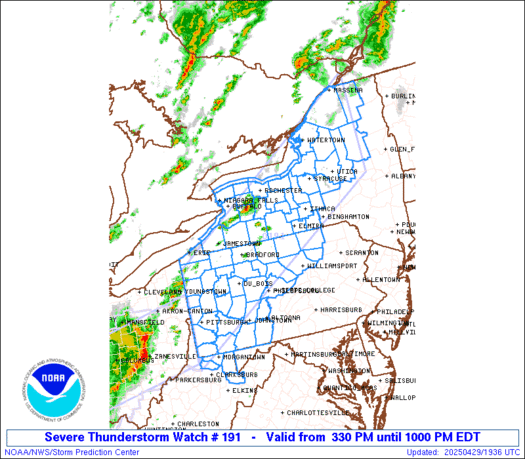
 STATUS REPORT ON WW 191 SEVERE WEATHER THREAT CONTINUES RIGHT OF A LINE FROM 25 ESE LWD
TO 10 SW DSM TO 20 NW DSM TO 40 N DSM TO 30 ENE FOD. ..WENDT..05/07/24 ATTN...WFO...DMX...FSD... STATUS REPORT FOR WT 191 SEVERE WEATHER THREAT CONTINUES FOR THE FOLLOWING AREAS IAC007-051-079-099-117-123-125-127-135-153-169-179-181-185-
070740- IA . IOWA COUNTIES INCLUDED ARE APPANOOSE DAVIS HAMILTON JASPER LUCAS MAHASKA MARION MARSHALL MONROE POLK STORY WAPELLO WARREN WAYNE THE WATCH STATUS MESSAGE IS FOR GUIDANCE PURPOSES ONLY. PLEASE
REFER TO WATCH COUNTY NOTIFICATION STATEMENTS FOR OFFICIAL
INFORMATION ON COUNTIES...INDEPENDENT CITIES AND MARINE ZONES
CLEARED FROM SEVERE THUNDERSTORM AND TORNADO WATCHES.
SPC Tornado Watch 191

WW 191 TORNADO IA NE SD 070030Z – 070800Z
 URGENT - IMMEDIATE BROADCAST REQUESTED
Tornado Watch Number 191
NWS Storm Prediction Center Norman OK
730 PM CDT Mon May 6 2024 The NWS Storm Prediction Center has issued a * Tornado Watch for portions of Western and Central Iowa Northeast Nebraska Far Southeast South Dakota * Effective this Monday night and Tuesday morning from 730 PM until 300 AM CDT. * Primary threats include... A couple tornadoes possible Scattered damaging winds likely with isolated significant gusts to 75 mph possible Isolated large hail events to 1.5 inches in diameter possible SUMMARY...Bands of storms will continue northeastward across the
region through the evening and early overnight, with damaging winds,
some hail, and a tornado risk. The tornado watch area is approximately along and 60 statute miles
east and west of a line from 20 miles north northwest of Storm Lake
IA to 25 miles east of Lamoni IA. For a complete depiction of the
watch see the associated watch outline update (WOUS64 KWNS WOU1). PRECAUTIONARY/PREPAREDNESS ACTIONS... REMEMBER...A Tornado Watch means conditions are favorable for
tornadoes and severe thunderstorms in and close to the watch
area. Persons in these areas should be on the lookout for
threatening weather conditions and listen for later statements
and possible warnings. && OTHER WATCH INFORMATION...CONTINUE...WW 188...WW 189...WW 190... AVIATION...Tornadoes and a few severe thunderstorms with hail
surface and aloft to 1.5 inches. Extreme turbulence and surface wind
gusts to 65 knots. A few cumulonimbi with maximum tops to 500. Mean
storm motion vector 23030. ...Guyer
SPC Tornado Watch 192 Status Reports

WW 0192 Status Updates 
 STATUS REPORT ON WW 192 SEVERE WEATHER THREAT CONTINUES RIGHT OF A LINE FROM GMJ TO 10 NW
UMN TO 20 N SGF TO 40 SSE SZL TO 30 NNE SZL TO 15 ENE CDJ TO 20 E
LWD. ..WENDT..05/07/24 ATTN...WFO...SGF...EAX... STATUS REPORT FOR WT 192 SEVERE WEATHER THREAT CONTINUES FOR THE FOLLOWING AREAS MOC001-009-015-029-041-043-053-059-067-077-085-089-105-109-115-
119-121-141-153-159-167-171-175-195-197-209-211-213-225-229-
070740- MO . MISSOURI COUNTIES INCLUDED ARE ADAIR BARRY BENTON CAMDEN CHARITON CHRISTIAN COOPER DALLAS DOUGLAS GREENE HICKORY HOWARD LACLEDE LAWRENCE LINN MCDONALD MACON MORGAN OZARK PETTIS POLK PUTNAM RANDOLPH SALINE SCHUYLER STONE SULLIVAN TANEY WEBSTER WRIGHT THE WATCH STATUS MESSAGE IS FOR GUIDANCE PURPOSES ONLY. PLEASE
REFER TO WATCH COUNTY NOTIFICATION STATEMENTS FOR OFFICIAL
INFORMATION ON COUNTIES...INDEPENDENT CITIES AND MARINE ZONES
CLEARED FROM SEVERE THUNDERSTORM AND TORNADO WATCHES.