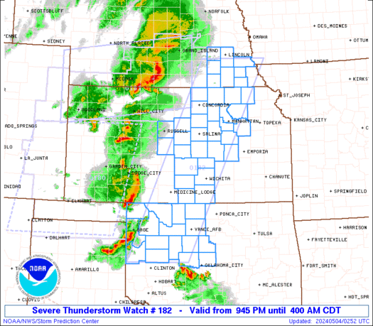
SPC Severe Thunderstorm Watch 23

WW 23 SEVERE TSTM AL GA 050325Z – 050900Z
WW 0023 Image

 URGENT - IMMEDIATE BROADCAST REQUESTED
Severe Thunderstorm Watch Number 23
NWS Storm Prediction Center Norman OK
925 PM CST Tue Mar 4 2025 The NWS Storm Prediction Center has issued a * Severe Thunderstorm Watch for portions of Eastern Alabama Western Georgia * Effective this Tuesday night and Wednesday morning from 925 PM until 300 AM CST. * Primary threats include... Scattered damaging wind gusts to 70 mph likely A tornado or two possible SUMMARY...A line of storms will continue to pose a risk for wind
damage, and possibly a brief tornado risk, from eastern Alabama into
western Georgia. The severe thunderstorm watch area is approximately along and 45
statute miles east and west of a line from 50 miles northwest of
Rome GA to 20 miles east southeast of Troy AL. For a complete
depiction of the watch see the associated watch outline update
(WOUS64 KWNS WOU3). PRECAUTIONARY/PREPAREDNESS ACTIONS... REMEMBER...A Severe Thunderstorm Watch means conditions are
favorable for severe thunderstorms in and close to the watch area.
Persons in these areas should be on the lookout for threatening
weather conditions and listen for later statements and possible
warnings. Severe thunderstorms can and occasionally do produce
tornadoes. && OTHER WATCH INFORMATION...CONTINUE...WW 22... AVIATION...A few severe thunderstorms with hail surface and aloft to
0.5 inches. Extreme turbulence and surface wind gusts to 60 knots. A
few cumulonimbi with maximum tops to 450. Mean storm motion vector
24040. ...Guyer 

Read more

SPC Tornado Watch 22

WW 22 TORNADO AL FL CW 042340Z – 050700Z
WW 0022 Image

 URGENT - IMMEDIATE BROADCAST REQUESTED
Tornado Watch Number 22
NWS Storm Prediction Center Norman OK
540 PM CST Tue Mar 4 2025 The NWS Storm Prediction Center has issued a * Tornado Watch for portions of Southern and South-Central Alabama Western Florida Panhandle Coastal Waters * Effective this Tuesday afternoon and Wednesday morning from 540 PM until 100 AM CST. * Primary threats include... A few tornadoes likely with a couple intense tornadoes possible Scattered damaging winds likely with isolated significant gusts to 80 mph possible Isolated large hail events to 1 inch in diameter possible SUMMARY...Severe storm potential including the risk for tornadoes
will increase through early/mid-evening especially across southwest
Alabama, and eventually parts of the western Florida Panhandle and
south-central Alabama. The tornado watch area is approximately along and 95 statute miles
north and south of a line from 60 miles north of Mobile AL to 45
miles north northeast of Crestview FL. For a complete depiction of
the watch see the associated watch outline update (WOUS64 KWNS
WOU2). PRECAUTIONARY/PREPAREDNESS ACTIONS... REMEMBER...A Tornado Watch means conditions are favorable for
tornadoes and severe thunderstorms in and close to the watch
area. Persons in these areas should be on the lookout for
threatening weather conditions and listen for later statements
and possible warnings. && OTHER WATCH INFORMATION...CONTINUE...WW 21... AVIATION...Tornadoes and a few severe thunderstorms with hail
surface and aloft to 1 inch. Extreme turbulence and surface wind
gusts to 70 knots. A few cumulonimbi with maximum tops to 500. Mean
storm motion vector 23035. ...Guyer 

Read more

SPC Tornado Watch 21

WW 21 TORNADO LA MS CW 041820Z – 050100Z
WW 0021 Image

 URGENT - IMMEDIATE BROADCAST REQUESTED
Tornado Watch Number 21
NWS Storm Prediction Center Norman OK
1220 PM CST Tue Mar 4 2025 The NWS Storm Prediction Center has issued a * Tornado Watch for portions of Eastern and Southeastern Louisiana Central and Southern Mississippi Coastal Waters * Effective this Tuesday afternoon and evening from 1220 PM until 700 PM CST. * Primary threats include... A few tornadoes likely with a couple intense tornadoes possible Scattered damaging winds and isolated significant gusts to 80 mph likely Isolated large hail events to 1 inch in diameter possible SUMMARY...A line of strong to severe thunderstorms continues to push
eastward towards eastern/southern LA along a progressive cold front.
The environment ahead of this front across eastern/southern LA and
into much of central and southern MS will become increasingly
favorable for continued severe thunderstorms over the next several
hours. Tornadoes are the primary severe hazard, with a few strong
(i.e. EF2+) tornadoes possible. Strong to potentially significant
(i.e. over 74 mph) wind gusts are possible within this line as well. The tornado watch area is approximately along and 90 statute miles
east and west of a line from 15 miles east northeast of Greenwood MS
to 35 miles south southeast of Houma LA. For a complete depiction of
the watch see the associated watch outline update (WOUS64 KWNS
WOU1). PRECAUTIONARY/PREPAREDNESS ACTIONS... REMEMBER...A Tornado Watch means conditions are favorable for
tornadoes and severe thunderstorms in and close to the watch
area. Persons in these areas should be on the lookout for
threatening weather conditions and listen for later statements
and possible warnings. && OTHER WATCH INFORMATION...CONTINUE...WW 20... AVIATION...Tornadoes and a few severe thunderstorms with hail
surface and aloft to 1 inch. Extreme turbulence and surface wind
gusts to 70 knots. A few cumulonimbi with maximum tops to 500. Mean
storm motion vector 24035. ...Mosier 

Read more