Round 2 of life-threatening heat menaces West with Las Vegas, Phoenix, Sacramento in crosshairs

Millions in the West will face a potentially deadly heat wave this week, the second in as many weeks.
24/7 Tornado Newsfeed
Millions in the West will face a potentially deadly heat wave this week, the second in as many weeks.

A massive ocean oddity that washed up on a northern Oregon beach this week turned out to be a recently discovered species of sunfish, according to the local aquarium.

NASA astronauts Suni Williams and Butch Wilmore took the public on a live tour of the Boeing Starliner on Saturday, two days after docking their spacecraft at the International Space Station.

Pollution from California wildfires is estimated to have claimed more than 52,000 lives over about a decade, according to a new study published in the Science Advances.

A deluge of tropical moisture is forecast to bombard Florida this week, possibly dropping a foot of rain in some cities by the end of the week leading to potential flooding across the state.
No watches are valid as of Sun Jun 9 09:42:02 UTC 2024.
WW 400 SEVERE TSTM KS 090050Z – 090800Z 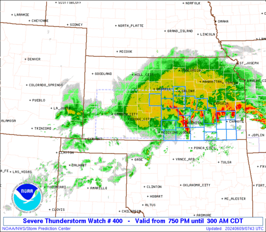
 URGENT - IMMEDIATE BROADCAST REQUESTED
Severe Thunderstorm Watch Number 400
NWS Storm Prediction Center Norman OK
750 PM CDT Sat Jun 8 2024 The NWS Storm Prediction Center has issued a * Severe Thunderstorm Watch for portions of Western and Central Kansas * Effective this Saturday night and Sunday morning from 750 PM until 300 AM CDT. * Primary threats include... Scattered damaging winds and isolated significant gusts to 80 mph likely Scattered large hail and isolated very large hail events to 2.5 inches in diameter possible A tornado or two possible SUMMARY...Severe thunderstorms will move east across the watch area
this evening and overnight, with a risk for significant damaging
wind gusts up to 80 mph and very large hail. A tornado or two will
also be possible. The severe thunderstorm watch area is approximately along and 60
statute miles either side of a line from 40 miles west of Garden
City KS to 20 miles north of Wichita KS. For a complete depiction of
the watch see the associated watch outline update (WOUS64 KWNS
WOU0). PRECAUTIONARY/PREPAREDNESS ACTIONS... REMEMBER...A Severe Thunderstorm Watch means conditions are
favorable for severe thunderstorms in and close to the watch area.
Persons in these areas should be on the lookout for threatening
weather conditions and listen for later statements and possible
warnings. Severe thunderstorms can and occasionally do produce
tornadoes. && OTHER WATCH INFORMATION...CONTINUE...WW 398...WW 399... AVIATION...A few severe thunderstorms with hail surface and aloft to
2.5 inches. Extreme turbulence and surface wind gusts to 70 knots. A
few cumulonimbi with maximum tops to 550. Mean storm motion vector
29035. ...Bunting
WW 399 SEVERE TSTM AR KS MO 082225Z – 090600Z 
 URGENT - IMMEDIATE BROADCAST REQUESTED
Severe Thunderstorm Watch Number 399
NWS Storm Prediction Center Norman OK
525 PM CDT Sat Jun 8 2024 The NWS Storm Prediction Center has issued a * Severe Thunderstorm Watch for portions of Northern Arkansas Far Southeast Kansas Southern Missouri * Effective this Saturday afternoon and Sunday morning from 525 PM until 100 AM CDT. * Primary threats include... Scattered large hail and isolated very large hail events to 2.5 inches in diameter possible Scattered damaging wind gusts to 70 mph possible A tornado or two possible SUMMARY...Severe thunderstorms will increase in coverage and move
southeast across the watch area through late this evening. Damaging
wind gusts are expected, in addition to large hail. possibly up to
2.5 inches in diameter. In addition, a tornado or two will also be
possible. The severe thunderstorm watch area is approximately along and 55
statute miles north and south of a line from 45 miles north
northwest of Joplin MO to 20 miles northeast of Poplar Bluff MO. For
a complete depiction of the watch see the associated watch outline
update (WOUS64 KWNS WOU9). PRECAUTIONARY/PREPAREDNESS ACTIONS... REMEMBER...A Severe Thunderstorm Watch means conditions are
favorable for severe thunderstorms in and close to the watch area.
Persons in these areas should be on the lookout for threatening
weather conditions and listen for later statements and possible
warnings. Severe thunderstorms can and occasionally do produce
tornadoes. && OTHER WATCH INFORMATION...CONTINUE...WW 398... AVIATION...A few severe thunderstorms with hail surface and aloft to
2.5 inches. Extreme turbulence and surface wind gusts to 60 knots. A
few cumulonimbi with maximum tops to 600. Mean storm motion vector
30025. ...Bunting