Tornado
SPC Severe Thunderstorm Watch 207
WW 207 SEVERE TSTM NC SC 081905Z – 090200Z 
 URGENT - IMMEDIATE BROADCAST REQUESTED
Severe Thunderstorm Watch Number 207
NWS Storm Prediction Center Norman OK
305 PM EDT Wed May 8 2024 The NWS Storm Prediction Center has issued a * Severe Thunderstorm Watch for portions of South-Central North Carolina Central South Carolina * Effective this Wednesday afternoon and evening from 305 PM until 1000 PM EDT. * Primary threats include... Scattered damaging wind gusts to 70 mph likely Scattered large hail and isolated very large hail events to 2 inches in diameter possible SUMMARY...A cluster of strong to severe thunderstorms is expected to
move into the Watch area from the west this afternoon into the
evening. Severe gusts and associated wind damage and large hail
will be the primary severe hazards. The severe thunderstorm watch area is approximately along and 55
statute miles north and south of a line from 20 miles south
southwest of Charlotte NC to 45 miles southeast of Fayetteville NC.
For a complete depiction of the watch see the associated watch
outline update (WOUS64 KWNS WOU7). PRECAUTIONARY/PREPAREDNESS ACTIONS... REMEMBER...A Severe Thunderstorm Watch means conditions are
favorable for severe thunderstorms in and close to the watch area.
Persons in these areas should be on the lookout for threatening
weather conditions and listen for later statements and possible
warnings. Severe thunderstorms can and occasionally do produce
tornadoes. && OTHER WATCH INFORMATION...CONTINUE...WW 203...WW 204...WW
205...WW 206... AVIATION...A few severe thunderstorms with hail surface and aloft to
2 inches. Extreme turbulence and surface wind gusts to 60 knots. A
few cumulonimbi with maximum tops to 500. Mean storm motion vector
26030. ...Smith
Watch: Michigan tornado flattens ‘every single tree on property’ in 45 seconds

Every single tree on one Portage, Michigan yard was leveled thanks to the powerful Tuesday evening tornado. Even so, the homeowner considers himself lucky.
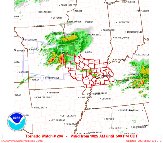
SPC Tornado Watch 206
WW 206 TORNADO IL IN KY TN 081815Z – 090200Z 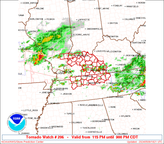
 URGENT - IMMEDIATE BROADCAST REQUESTED
Tornado Watch Number 206
NWS Storm Prediction Center Norman OK
115 PM CDT Wed May 8 2024 The NWS Storm Prediction Center has issued a * Tornado Watch for portions of Southern Illinois Southern Indiana Central Kentucky Middle Tennessee * Effective this Wednesday afternoon and evening from 115 PM until 900 PM CDT. * Primary threats include... A few tornadoes likely with a couple intense tornadoes possible Widespread damaging winds and isolated significant gusts to 80 mph likely Scattered large hail and isolated very large hail events to 2.5 inches in diameter likely SUMMARY...Supercells are forecast to continue to develop and
intensify across the Watch area as the airmass recovers in wake of
an earlier thunderstorm complex. Large to very large hail,
tornadoes, and damaging gusts are possible. A strong tornado is
possible with any mature and intense supercell. The tornado watch area is approximately along and 70 statute miles
north and south of a line from 55 miles northwest of Fort Campbell
KY to 55 miles north of Crossville TN. For a complete depiction of
the watch see the associated watch outline update (WOUS64 KWNS
WOU6). PRECAUTIONARY/PREPAREDNESS ACTIONS... REMEMBER...A Tornado Watch means conditions are favorable for
tornadoes and severe thunderstorms in and close to the watch
area. Persons in these areas should be on the lookout for
threatening weather conditions and listen for later statements
and possible warnings. && OTHER WATCH INFORMATION...CONTINUE...WW 202...WW 203...WW
204...WW 205... AVIATION...Tornadoes and a few severe thunderstorms with hail
surface and aloft to 2.5 inches. Extreme turbulence and surface wind
gusts to 70 knots. A few cumulonimbi with maximum tops to 500. Mean
storm motion vector 24035. ...Smith
Parts of South Texas experiencing a dip in air quality from agricultural smoke in Mexico
Places like Brownsville and Corpus Christi will see the worst of the air quality on Wednesday and Thursday.
SPC Tornado Watch 205 Status Reports
WW 0205 Status Updates 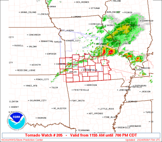
 STATUS REPORT ON WW 205 THE SEVERE WEATHER THREAT CONTINUES ACROSS THE ENTIRE WATCH AREA. ..BENTLEY..05/08/24 ATTN...WFO...SGF... STATUS REPORT FOR WT 205 SEVERE WEATHER THREAT CONTINUES FOR THE FOLLOWING AREAS KSC011-021-037-081840- KS . KANSAS COUNTIES INCLUDED ARE BOURBON CHEROKEE CRAWFORD MOC009-011-029-039-043-057-059-065-067-077-085-091-097-105-109-
119-145-149-153-161-167-169-185-203-209-213-215-217-225-229-
081840- MO . MISSOURI COUNTIES INCLUDED ARE BARRY BARTON CAMDEN CEDAR CHRISTIAN DADE DALLAS DENT DOUGLAS GREENE HICKORY HOWELL JASPER LACLEDE LAWRENCE MCDONALD NEWTON OREGON OZARK PHELPS POLK PULASKI ST. CLAIR SHANNON STONE TANEY TEXAS VERNON WEBSTER WRIGHT
SPC Tornado Watch 205
WW 205 TORNADO KS MO 081655Z – 090000Z
 URGENT - IMMEDIATE BROADCAST REQUESTED
Tornado Watch Number 205
NWS Storm Prediction Center Norman OK
1155 AM CDT Wed May 8 2024 The NWS Storm Prediction Center has issued a * Tornado Watch for portions of Extreme southeast Kansas Southern Missouri * Effective this Wednesday morning and evening from 1155 AM until 700 PM CDT. * Primary threats include... A few tornadoes and a couple intense tornadoes possible Scattered damaging winds and isolated significant gusts to 75 mph likely Scattered large hail and isolated very large hail events to 3 inches in diameter likely SUMMARY...Scattered supercell development is expected this afternoon
along and south of a slow-moving outflow boundary in Missouri. The
storm environment will be most favorable for tornadoes close to the
stalling outflow boundary, where an isolated strong (EF2+) tornado
will be possible. Otherwise, very large hail of 2-3 inches in
diameter will be possible with the supercells, and the potential for
damaging gusts up to 75 mph will increase with any upscale growth
into clusters. The tornado watch area is approximately along and 50 statute miles
north and south of a line from 20 miles west northwest of Joplin MO
to 45 miles northeast of West Plains MO. For a complete depiction of
the watch see the associated watch outline update (WOUS64 KWNS
WOU5). PRECAUTIONARY/PREPAREDNESS ACTIONS... REMEMBER...A Tornado Watch means conditions are favorable for
tornadoes and severe thunderstorms in and close to the watch
area. Persons in these areas should be on the lookout for
threatening weather conditions and listen for later statements
and possible warnings. && OTHER WATCH INFORMATION...CONTINUE...WW 202...WW 203...WW 204... AVIATION...Tornadoes and a few severe thunderstorms with hail
surface and aloft to 3 inches. Extreme turbulence and surface wind
gusts to 65 knots. A few cumulonimbi with maximum tops to 550. Mean
storm motion vector 27030. ...Thompson
Watch as guests run for cover while tornado strikes Oklahoma Hampton Inn

Cleanup efforts continue in Oklahoma after a powerful and deadly tornado with a preliminary rating of EF-4 struck the communities of Barnsdall and Bartlesville Monday night, and an intense video recorded in a local Hampton Inn shows the dramatic moments guests were running for cover as the twister hit, sending debris flying into the air while sirens blared.