Watch: Brilliant lightning appears to hit erupting volcano in Guatemala

Crowds that flocked to watch the Volcano of Fire erupt last month were treated to a crazy light show when lightning apparently struck the mountain top.
24/7 Tornado Newsfeed
Crowds that flocked to watch the Volcano of Fire erupt last month were treated to a crazy light show when lightning apparently struck the mountain top.
WW 238 SEVERE TSTM TX CW 132135Z – 140300Z 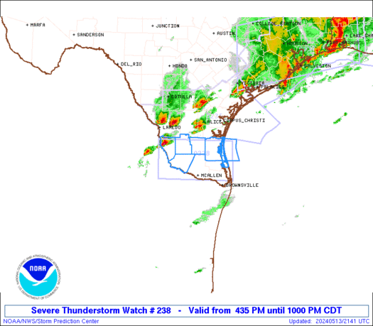
 URGENT - IMMEDIATE BROADCAST REQUESTED
Severe Thunderstorm Watch Number 238
NWS Storm Prediction Center Norman OK
435 PM CDT Mon May 13 2024 The NWS Storm Prediction Center has issued a * Severe Thunderstorm Watch for portions of Deep South Texas Coastal Waters * Effective this Monday afternoon and evening from 435 PM until 1000 PM CDT. * Primary threats include... Scattered large hail and isolated very large hail events to 2 inches in diameter possible Isolated damaging wind gusts to 70 mph possible SUMMARY...Thunderstorms will build/move southeastward into deep
south Texas this evening, with a few cells posing a risk of damaging
winds and large hail. The severe thunderstorm watch area is approximately along and 40
statute miles north and south of a line from 85 miles west northwest
of Mcallen TX to 75 miles east northeast of Mcallen TX. For a
complete depiction of the watch see the associated watch outline
update (WOUS64 KWNS WOU8). PRECAUTIONARY/PREPAREDNESS ACTIONS... REMEMBER...A Severe Thunderstorm Watch means conditions are
favorable for severe thunderstorms in and close to the watch area.
Persons in these areas should be on the lookout for threatening
weather conditions and listen for later statements and possible
warnings. Severe thunderstorms can and occasionally do produce
tornadoes. && OTHER WATCH INFORMATION...CONTINUE...WW 236...WW 237... AVIATION...A few severe thunderstorms with hail surface and aloft to
2 inches. Extreme turbulence and surface wind gusts to 60 knots. A
few cumulonimbi with maximum tops to 500. Mean storm motion vector
29030. ...Hart

The National Hurricane Center is tracking a system in the Eastern Pacific Ocean that could become a tropical disturbance.
WW 237 SEVERE TSTM LA TX CW 131800Z – 140100Z 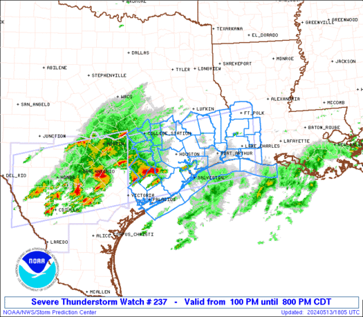
 URGENT - IMMEDIATE BROADCAST REQUESTED
Severe Thunderstorm Watch Number 237
NWS Storm Prediction Center Norman OK
100 PM CDT Mon May 13 2024 The NWS Storm Prediction Center has issued a * Severe Thunderstorm Watch for portions of Southwest Louisiana Southeast Texas Coastal Waters * Effective this Monday afternoon and evening from 100 PM until 800 PM CDT. * Primary threats include... Scattered damaging winds and isolated significant gusts to 80 mph likely Scattered large hail and isolated very large hail events to 3 inches in diameter likely A tornado or two possible SUMMARY...Clusters of storms are expected to move and develop
eastward into southeast Texas and southwest Louisiana through this
evening. The storm environment favors a mix of supercells capable
of producing very large hail up to 3 inches in diameter, as well as
some upscale growth into clusters/bowing segments with the potential
for damaging winds of 60-80 mph. A tornado or two could occur with
favorable storm/boundary interactions. The severe thunderstorm watch area is approximately along and 65
statute miles north and south of a line from 50 miles north of
Victoria TX to 25 miles east northeast of Lake Charles LA. For a
complete depiction of the watch see the associated watch outline
update (WOUS64 KWNS WOU7). PRECAUTIONARY/PREPAREDNESS ACTIONS... REMEMBER...A Severe Thunderstorm Watch means conditions are
favorable for severe thunderstorms in and close to the watch area.
Persons in these areas should be on the lookout for threatening
weather conditions and listen for later statements and possible
warnings. Severe thunderstorms can and occasionally do produce
tornadoes. && OTHER WATCH INFORMATION...CONTINUE...WW 235...WW 236... AVIATION...A few severe thunderstorms with hail surface and aloft to
3 inches. Extreme turbulence and surface wind gusts to 70 knots. A
few cumulonimbi with maximum tops to 600. Mean storm motion vector
27030. ...Thompson

Cleanup efforts are underway in a Pennsylvania town south of Pittsburgh after an EF-2 tornado ripped through the community on Saturday, injuring at least two people and sending parishioners of a local church running for safety as it took a direct hit during a service.

Canada's wildfire season has erupted as dozens of blazes burn in the country's western provinces, and smoke from those fires is choking the skies over the Upper Midwest early this week.
Watch live as the KSAT Storm Chaser drives around and tracks storms in the San Antonio area.