Flower Moon: When you can see the last full Moon of spring

The last full Moon of spring, which is called the Flower Moon, happens Thursday night.
24/7 Tornado Newsfeed
The last full Moon of spring, which is called the Flower Moon, happens Thursday night.

Heat-stressed, endangered howler monkeys are dropping out of trees and dying across Tabasco and Chiapas, Mexico, as the third relentless heat wave this season bakes the region.

Live coverage and updates on severe thunderstorms impacting portions of Texas from the @texasstormchasers team… #txwx #tornado #hail #wind #damage #weatherreport Join this channel to get access to perks: https://www.youtube.com/channel/UCoIfgmxArIATc2EpHD3W9EA/join Check out our current LIVE STREAM: https://texasweather.video/ Our FREE WEATHER APP: https://texasweather.app/ Our WEBSITE/RADAR: https://www.texasstormchasers.com Our SOCIAL PLATFORMS: https://linktr.ee/texasstormchasers Donations – Paypal@texasstormchasers.com *Enable 4K 60FPS […]
WW 295 TORNADO OK TX 232130Z – 240400Z 
 URGENT - IMMEDIATE BROADCAST REQUESTED
Tornado Watch Number 295
NWS Storm Prediction Center Norman OK
430 PM CDT Thu May 23 2024 The NWS Storm Prediction Center has issued a * Tornado Watch for portions of Southwest Oklahoma The Edwards Plateau into northwest Texas * Effective this Thursday afternoon and evening from 430 PM until 1100 PM CDT. * Primary threats include... A couple tornadoes possible Scattered large hail and isolated very large hail events to 3.5 inches in diameter possible Isolated damaging wind gusts to 70 mph possible SUMMARY...A few supercells are expected to form late this afternoon
along the dryline, and storms will move slowly eastward through late
evening. The storm environment favors isolated very large hail (up
to 3.5 inches in diameter) as the main threat, though a couple of
tornadoes will also be possible. The tornado watch area is approximately along and 45 statute miles
east and west of a line from 20 miles northwest of Clinton OK to 35
miles southeast of San Angelo TX. For a complete depiction of the
watch see the associated watch outline update (WOUS64 KWNS WOU5). PRECAUTIONARY/PREPAREDNESS ACTIONS... REMEMBER...A Tornado Watch means conditions are favorable for
tornadoes and severe thunderstorms in and close to the watch
area. Persons in these areas should be on the lookout for
threatening weather conditions and listen for later statements
and possible warnings. && OTHER WATCH INFORMATION...CONTINUE...WW 293...WW 294... AVIATION...Tornadoes and a few severe thunderstorms with hail
surface and aloft to 3.5 inches. Extreme turbulence and surface wind
gusts to 60 knots. A few cumulonimbi with maximum tops to 600. Mean
storm motion vector 26020. ...Thompson
WW 0294 Status Updates 
 STATUS REPORT ON WW 294 THE SEVERE WEATHER THREAT CONTINUES ACROSS THE ENTIRE WATCH AREA. ..DEAN..05/23/24 ATTN...WFO...BIS...FGF...LBF...FSD...ABR...UNR... STATUS REPORT FOR WS 294 SEVERE WEATHER THREAT CONTINUES FOR THE FOLLOWING AREAS NEC005-009-015-017-029-031-041-049-063-069-071-075-085-089-091-
101-103-111-113-115-117-135-149-171-183-232140- NE . NEBRASKA COUNTIES INCLUDED ARE ARTHUR BLAINE BOYD BROWN CHASE CHERRY CUSTER DEUEL FRONTIER GARDEN GARFIELD GRANT HAYES HOLT HOOKER KEITH KEYA PAHA LINCOLN LOGAN LOUP MCPHERSON PERKINS ROCK THOMAS WHEELER NDC021-029-045-047-051-073-077-081-232140- ND . NORTH DAKOTA COUNTIES INCLUDED ARE DICKEY EMMONS LAMOURE LOGAN MCINTOSH RANSOM RICHLAND SARGENT
WW 294 SEVERE TSTM ND NE SD 232025Z – 240400Z
 URGENT - IMMEDIATE BROADCAST REQUESTED
Severe Thunderstorm Watch Number 294
NWS Storm Prediction Center Norman OK
325 PM CDT Thu May 23 2024 The NWS Storm Prediction Center has issued a * Severe Thunderstorm Watch for portions of Southeast North Dakota Central Nebraska Central and Eastern South Dakota * Effective this Thursday afternoon and evening from 325 PM until 1100 PM CDT. * Primary threats include... Scattered damaging wind gusts to 70 mph likely Scattered large hail and isolated very large hail events to 2.5 inches in diameter possible A tornado or two possible SUMMARY...Thunderstorms will increase in coverage through the
afternoon across the watch area. Very large hail and damaging winds
will be possible in the stronger cells. The severe thunderstorm watch area is approximately along and 55
statute miles east and west of a line from 60 miles north northeast
of Aberdeen SD to 40 miles southwest of North Platte NE. For a
complete depiction of the watch see the associated watch outline
update (WOUS64 KWNS WOU4). PRECAUTIONARY/PREPAREDNESS ACTIONS... REMEMBER...A Severe Thunderstorm Watch means conditions are
favorable for severe thunderstorms in and close to the watch area.
Persons in these areas should be on the lookout for threatening
weather conditions and listen for later statements and possible
warnings. Severe thunderstorms can and occasionally do produce
tornadoes. && OTHER WATCH INFORMATION...CONTINUE...WW 292...WW 293... AVIATION...A few severe thunderstorms with hail surface and aloft to
2.5 inches. Extreme turbulence and surface wind gusts to 60 knots. A
few cumulonimbi with maximum tops to 500. Mean storm motion vector
25030. ...Hart

A ferocious thunderstorm rolled through New York City late Thursday morning, peppering the Big Apple with several dozen lightning strikes.
WW 293 SEVERE TSTM KY TN VA 231745Z – 240000Z 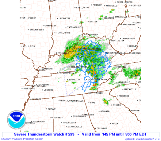
 URGENT - IMMEDIATE BROADCAST REQUESTED
Severe Thunderstorm Watch Number 293
NWS Storm Prediction Center Norman OK
145 PM EDT Thu May 23 2024 The NWS Storm Prediction Center has issued a * Severe Thunderstorm Watch for portions of Central and Eastern Kentucky Middle and East Tennessee Extreme Southwest Virginia * Effective this Thursday afternoon and evening from 145 PM until 800 PM EDT. * Primary threats include... Scattered damaging wind gusts to 65 mph possible Scattered large hail events to 1.5 inches in diameter possible SUMMARY...Thunderstorms are increasing across parts of central
Kentucky and middle Tennessee. These storms will spread eastward
across the watch area, with an occasional risk of damaging wind
gusts and hail. The severe thunderstorm watch area is approximately along and 65
statute miles north and south of a line from 20 miles southwest of
Nashville TN to 5 miles east southeast of Jackson KY. For a complete
depiction of the watch see the associated watch outline update
(WOUS64 KWNS WOU3). PRECAUTIONARY/PREPAREDNESS ACTIONS... REMEMBER...A Severe Thunderstorm Watch means conditions are
favorable for severe thunderstorms in and close to the watch area.
Persons in these areas should be on the lookout for threatening
weather conditions and listen for later statements and possible
warnings. Severe thunderstorms can and occasionally do produce
tornadoes. && OTHER WATCH INFORMATION...CONTINUE...WW 292... AVIATION...A few severe thunderstorms with hail surface and aloft to
1.5 inches. Extreme turbulence and surface wind gusts to 55 knots. A
few cumulonimbi with maximum tops to 500. Mean storm motion vector
25025. ...Hart