SPC Tornado Watch 240 Status Reports

WW 0240 Status Updates
WW 0240 Status Image

 STATUS REPORT ON WW 240 THE SEVERE WEATHER THREAT CONTINUES ACROSS THE ENTIRE WATCH AREA. ..DEAN..05/14/24 ATTN...WFO...TAE... STATUS REPORT FOR WT 240 SEVERE WEATHER THREAT CONTINUES FOR THE FOLLOWING AREAS FLC005-013-029-037-039-045-059-063-065-067-073-077-079-123-129-
131-133-140840- FL . FLORIDA COUNTIES INCLUDED ARE BAY CALHOUN DIXIE FRANKLIN GADSDEN GULF HOLMES JACKSON JEFFERSON LAFAYETTE LEON LIBERTY MADISON TAYLOR WAKULLA WALTON WASHINGTON GAC027-087-131-185-253-275-140840- GA . GEORGIA COUNTIES INCLUDED ARE BROOKS DECATUR GRADY LOWNDES SEMINOLE THOMAS GMZ730-750-752-755-765-770-772-775-140840- CW 

Read more

SPC Tornado Watch 240

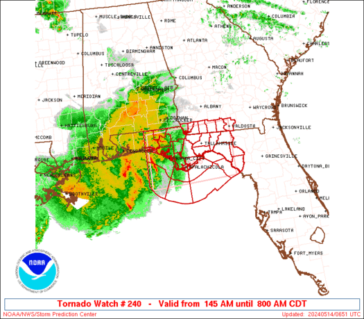
WW 240 TORNADO FL GA CW 140645Z – 141300Z
WW 0240 Image

 URGENT - IMMEDIATE BROADCAST REQUESTED
Tornado Watch Number 240
NWS Storm Prediction Center Norman OK
145 AM CDT Tue May 14 2024 The NWS Storm Prediction Center has issued a * Tornado Watch for portions of Northern Florida Far Southern Georgia Coastal Waters * Effective this Tuesday morning from 145 AM until 800 AM CDT. * Primary threats include... A couple tornadoes possible Scattered damaging wind gusts to 70 mph possible SUMMARY...A well-organized complex of storms over the northeast Gulf
of Mexico will move into the Florida Panhandle and other parts of
northern Florida, and eventually far southern Georgia, through the
early morning hours. Severe/tornado potential is expected to
increase as the atmosphere ahead of these storms further
destabilizes. The tornado watch area is approximately along and 60 statute miles
north and south of a line from 40 miles west southwest of Panama
City FL to 45 miles south of Valdosta GA. For a complete depiction
of the watch see the associated watch outline update (WOUS64 KWNS
WOU0). PRECAUTIONARY/PREPAREDNESS ACTIONS... REMEMBER...A Tornado Watch means conditions are favorable for
tornadoes and severe thunderstorms in and close to the watch
area. Persons in these areas should be on the lookout for
threatening weather conditions and listen for later statements
and possible warnings. && AVIATION...Tornadoes and a few severe thunderstorms with hail
surface and aloft to 1.5 inches. Extreme turbulence and surface wind
gusts to 60 knots. A few cumulonimbi with maximum tops to 550. Mean
storm motion vector 26035. ...Guyer 

Read more

SPC Severe Thunderstorm Watch 239

WW 239 SEVERE TSTM LA MS CW 132225Z – 140500Z
WW 0239 Image

 URGENT - IMMEDIATE BROADCAST REQUESTED
Severe Thunderstorm Watch Number 239
NWS Storm Prediction Center Norman OK
525 PM CDT Mon May 13 2024 The NWS Storm Prediction Center has issued a * Severe Thunderstorm Watch for portions of Central and Southeast Louisiana Southern Mississippi Coastal Waters * Effective this Monday afternoon from 525 PM until Midnight CDT. * Primary threats include... Scattered damaging winds and isolated significant gusts to 75 mph likely Scattered large hail and isolated very large hail events to 2 inches in diameter possible A tornado or two possible SUMMARY...A fast moving line of thunderstorms over southwest
Louisiana will track across the watch area during the evening. Damaging winds are the main threat with these storms, along with a
possible tornado or two along the leading edge of activity. The severe thunderstorm watch area is approximately along and 65
statute miles north and south of a line from 40 miles northwest of
Intracoastal City LA to 55 miles southeast of Gulfport MS. For a
complete depiction of the watch see the associated watch outline
update (WOUS64 KWNS WOU9). PRECAUTIONARY/PREPAREDNESS ACTIONS... REMEMBER...A Severe Thunderstorm Watch means conditions are
favorable for severe thunderstorms in and close to the watch area.
Persons in these areas should be on the lookout for threatening
weather conditions and listen for later statements and possible
warnings. Severe thunderstorms can and occasionally do produce
tornadoes. && OTHER WATCH INFORMATION...CONTINUE...WW 236...WW 237...WW 238... AVIATION...A few severe thunderstorms with hail surface and aloft to
2 inches. Extreme turbulence and surface wind gusts to 65 knots. A
few cumulonimbi with maximum tops to 500. Mean storm motion vector
27035. ...Hart 

Read more

SPC Severe Thunderstorm Watch 238

WW 238 SEVERE TSTM TX CW 132135Z – 140300Z
WW 0238 Image

 URGENT - IMMEDIATE BROADCAST REQUESTED
Severe Thunderstorm Watch Number 238
NWS Storm Prediction Center Norman OK
435 PM CDT Mon May 13 2024 The NWS Storm Prediction Center has issued a * Severe Thunderstorm Watch for portions of Deep South Texas Coastal Waters * Effective this Monday afternoon and evening from 435 PM until 1000 PM CDT. * Primary threats include... Scattered large hail and isolated very large hail events to 2 inches in diameter possible Isolated damaging wind gusts to 70 mph possible SUMMARY...Thunderstorms will build/move southeastward into deep
south Texas this evening, with a few cells posing a risk of damaging
winds and large hail. The severe thunderstorm watch area is approximately along and 40
statute miles north and south of a line from 85 miles west northwest
of Mcallen TX to 75 miles east northeast of Mcallen TX. For a
complete depiction of the watch see the associated watch outline
update (WOUS64 KWNS WOU8). PRECAUTIONARY/PREPAREDNESS ACTIONS... REMEMBER...A Severe Thunderstorm Watch means conditions are
favorable for severe thunderstorms in and close to the watch area.
Persons in these areas should be on the lookout for threatening
weather conditions and listen for later statements and possible
warnings. Severe thunderstorms can and occasionally do produce
tornadoes. && OTHER WATCH INFORMATION...CONTINUE...WW 236...WW 237... AVIATION...A few severe thunderstorms with hail surface and aloft to
2 inches. Extreme turbulence and surface wind gusts to 60 knots. A
few cumulonimbi with maximum tops to 500. Mean storm motion vector
29030. ...Hart 

Read more