WW 241 TORNADO FL GA CW 141025Z – 141700Z
URGENT - IMMEDIATE BROADCAST REQUESTED
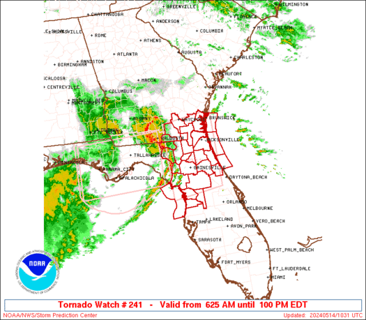
Tornado Watch Number 241
NWS Storm Prediction Center Norman OK
625 AM EDT Tue May 14 2024 The NWS Storm Prediction Center has issued a * Tornado Watch for portions of Northern and Central Florida Southeast Georgia Coastal Waters * Effective this Tuesday morning and afternoon from 625 AM until 100 PM EDT. * Primary threats include... A couple tornadoes possible Scattered damaging wind gusts to 70 mph possible SUMMARY...Storms expected to further develop and intensity across
the region as they generally spread east-northeastward through the
morning, with damaging wind potential and a tornado risk. The tornado watch area is approximately along and 85 statute miles
north and south of a line from 50 miles west northwest of
Gainesville FL to 15 miles north northeast of St Augustine FL. For a
complete depiction of the watch see the associated watch outline
update (WOUS64 KWNS WOU1). PRECAUTIONARY/PREPAREDNESS ACTIONS... REMEMBER...A Tornado Watch means conditions are favorable for
tornadoes and severe thunderstorms in and close to the watch
area. Persons in these areas should be on the lookout for
threatening weather conditions and listen for later statements
and possible warnings. && OTHER WATCH INFORMATION...CONTINUE...WW 240... AVIATION...Tornadoes and a few severe thunderstorms with hail
surface and aloft to 1 inch. Extreme turbulence and surface wind
gusts to 60 knots. A few cumulonimbi with maximum tops to 500. Mean
storm motion vector 25030. ...Guyer
Read more


