Tornado
SPC Severe Thunderstorm Watch 244
WW 244 SEVERE TSTM FL CW 151450Z – 152100Z 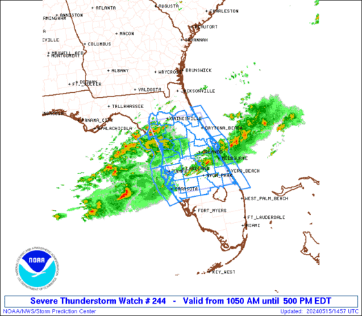
 URGENT - IMMEDIATE BROADCAST REQUESTED
Severe Thunderstorm Watch Number 244
NWS Storm Prediction Center Norman OK
1050 AM EDT Wed May 15 2024 The NWS Storm Prediction Center has issued a * Severe Thunderstorm Watch for portions of Northern/central Florida Peninsula Coastal Waters * Effective this Wednesday morning and afternoon from 1050 AM until 500 PM EDT. * Primary threats include... Scattered damaging wind gusts to 70 mph possible Scattered large hail events to 1.5 inches in diameter possible A tornado or two possible SUMMARY...Thunderstorms will spread eastward across parts of the
northern/central FL Peninsula through this afternoon, while posing a
threat for mainly large hail and damaging winds. The severe thunderstorm watch area is approximately along and 60
statute miles east and west of a line from 15 miles east of
Gainesville FL to 30 miles south of Avon Park FL. For a complete
depiction of the watch see the associated watch outline update
(WOUS64 KWNS WOU4). PRECAUTIONARY/PREPAREDNESS ACTIONS... REMEMBER...A Severe Thunderstorm Watch means conditions are
favorable for severe thunderstorms in and close to the watch area.
Persons in these areas should be on the lookout for threatening
weather conditions and listen for later statements and possible
warnings. Severe thunderstorms can and occasionally do produce
tornadoes. && OTHER WATCH INFORMATION...This severe thunderstorm watch replaces
tornado watch number 243. Watch number 243 will not be in effect
after 1050 AM EDT. AVIATION...A few severe thunderstorms with hail surface and aloft to
1.5 inches. Extreme turbulence and surface wind gusts to 60 knots. A
few cumulonimbi with maximum tops to 500. Mean storm motion vector
26035. ...Gleason
Tornado Watch issued in Florida as severe weather threatens millions across 3 areas of US on Wednesday

Wednesday is shaping up to be an active day for severe weather in three parts of the U.S. with powerful thunderstorms capable of producing damaging wind gusts, large hail and possible tornadoes targeting areas from the Plains to the East Coast.
Gully-washer heading to Texas

Thunderstorm chances are on the rise across western parts of Texas today, and it goes downhill Thursday through Friday morning for the eastern half of Texas â plus the north, too. This afternoon’s strongest storms may produce damaging winds, hail, and heavy rain. Thursdayâs storms could be more rambunctious with a risk of very large […]
The Daily Weather Update from FOX Weather: Severe weather, serious flood threat take aim at South

Start your day with the latest weather news. Relentless storms have left the ground in parts of the South saturated and rivers swollen. Now, the region faces another round of severe weather and heavy rain that could lead to more flooding.
SPC Tornado Watch 243
WW 243 TORNADO FL CW 150645Z – 151500Z 
 URGENT - IMMEDIATE BROADCAST REQUESTED
Tornado Watch Number 243
NWS Storm Prediction Center Norman OK
245 AM EDT Wed May 15 2024 The NWS Storm Prediction Center has issued a * Tornado Watch for portions of Northern and Central Florida Coastal Waters * Effective this Wednesday morning from 245 AM until 1100 AM EDT. * Primary threats include... A couple tornadoes possible Isolated damaging wind gusts to 70 mph possible Isolated large hail events to 1.5 inches in diameter possible SUMMARY...At least isolated severe storms including supercells are
expected to develop through the predawn hours, especially across the
north-central Florida Peninsula. The severe risk/tornado potential
may further increase toward and beyond sunrise across broader
portions of the central Peninsula. The tornado watch area is approximately along and 70 statute miles
north and south of a line from 30 miles northwest of Saint
Petersburg FL to 20 miles east of Daytona Beach FL. For a complete
depiction of the watch see the associated watch outline update
(WOUS64 KWNS WOU3). PRECAUTIONARY/PREPAREDNESS ACTIONS... REMEMBER...A Tornado Watch means conditions are favorable for
tornadoes and severe thunderstorms in and close to the watch
area. Persons in these areas should be on the lookout for
threatening weather conditions and listen for later statements
and possible warnings. && AVIATION...Tornadoes and a few severe thunderstorms with hail
surface and aloft to 1.5 inches. Extreme turbulence and surface wind
gusts to 60 knots. A few cumulonimbi with maximum tops to 550. Mean
storm motion vector 25035. ...Guyer
2024 Eastern Pacific hurricane season guide: Hereâs what to know about this yearâs storms

The 2024 eastern Pacific hurricane season began on May 15 and runs through November 30. In 2023, an El Nino pattern produced 17 named storms, ten hurricanes and eight major cyclones in the basin. Two of the major hurricanes â Dora and Otis â were retired for their connections to mass devastation in Hawaii and southwestern Mexico.
What is a tropical upper tropospheric trough (TUTT)?
?")
A tropical upper tropospheric trough is an elongated area of low pressure in the upper levels of the atmosphere. These semi-permanent features can become cut off, forming what is known as a TUTT low. TUTTs produce a significant amount of wind shear that can disrupt tropical cyclones.
Punxsutawney Philâs pups given weather-inspired names

The Punxsutawney Groundhog Club announced the names of baby groundhogs on Motherâs Day. The female pup was named Sunny, and the boy will be known as Shadow. The family of four lives in an enclosure at the Punxsutawney Memorial Library in downtown Punxsutawney, Pennsylvania.