SPC – No watches are valid as of Thu May 16 06:02:01 UTC 2024
No watches are valid as of Thu May 16 06:02:01 UTC 2024.
24/7 Tornado Newsfeed
No watches are valid as of Thu May 16 06:02:01 UTC 2024.

Researchers at Binghamton University and the University of Colorado are studying how ants bind together to survive flooding. These rafts allow the colony to stay afloat and endure heavy rainfall events.
WW 247 SEVERE TSTM KS OK 152255Z – 160600Z 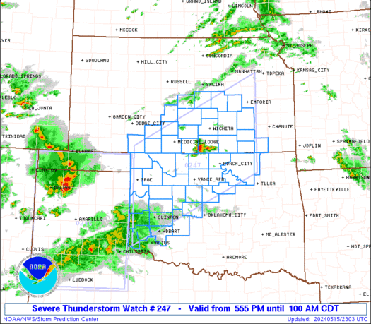
 URGENT - IMMEDIATE BROADCAST REQUESTED
Severe Thunderstorm Watch Number 247
NWS Storm Prediction Center Norman OK
555 PM CDT Wed May 15 2024 The NWS Storm Prediction Center has issued a * Severe Thunderstorm Watch for portions of South-Central Kansas Western and Northern Oklahoma * Effective this Wednesday afternoon and Thursday morning from 555 PM until 100 AM CDT. * Primary threats include... Scattered damaging winds and isolated significant gusts to 80 mph likely Scattered large hail and isolated very large hail events to 2.5 inches in diameter likely A tornado or two possible SUMMARY...Several clusters of strong to severe thunderstorms are
forecast to develop this evening across western into northern
Oklahoma and into south-central Kansas. The environment will
support a mix of supercells and organized linear clusters. A threat
for large to very large hail will seemingly be greatest through the
mid evening with any supercells. A non-zero risk for a tornado this
evening may focus over far northern Oklahoma and southern Kansas. By mid to late evening, the risk for severe gusts will likely become
the primary severe hazard. The severe thunderstorm watch area is approximately along and 90
statute miles north and south of a line from 55 miles northwest of
Clinton OK to 40 miles south southeast of Emporia KS. For a complete
depiction of the watch see the associated watch outline update
(WOUS64 KWNS WOU7). PRECAUTIONARY/PREPAREDNESS ACTIONS... REMEMBER...A Severe Thunderstorm Watch means conditions are
favorable for severe thunderstorms in and close to the watch area.
Persons in these areas should be on the lookout for threatening
weather conditions and listen for later statements and possible
warnings. Severe thunderstorms can and occasionally do produce
tornadoes. && OTHER WATCH INFORMATION...CONTINUE...WW 245...WW 246... AVIATION...A few severe thunderstorms with hail surface and aloft to
2.5 inches. Extreme turbulence and surface wind gusts to 70 knots. A
few cumulonimbi with maximum tops to 500. Mean storm motion vector
24035. ...Smith

Rocket Lab is preparing to launch the first of two tiny NASA spacecraft designed to study how heat is emitted and absorbed from Earth's polar regions, which influences global weather patterns.

Since 2020, only two new NFL stadiums have opened. A building boom is on the horizon, with several new stadiums in the works.

Join this channel to get access to perks: https://www.youtube.com/channel/UCoIfgmxArIATc2EpHD3W9EA/join Check out our current LIVE STREAM: https://texasweather.video/ Our FREE WEATHER APP: https://texasweather.app/ Our WEBSITE/RADAR: https://www.texasstormchasers.com Our SOCIAL PLATFORMS: https://linktr.ee/texasstormchasers Donations – Paypal@texasstormchasers.com *Enable 4K 60FPS when possible for best viewing results* #texas #texasweather #weather #abilene #alpine #amarillo #austin #beaumont #beeville #bigbend #brownsville #brownwood #canadian #childress #collegestation […]

The last sugar mill in Texas shut its doors last month, citing a lack of water. Farmers were left to plow under the crop and wonder what drought would claim next.

The catastrophic and deadly flooding that has left much of Brazilâs Rio Grande do Sol buried in feet of floodwaters for weeks may remain for at least another month, Reuters reported Wednesday.
