SPC – No watches are valid as of Sat May 18 05:02:02 UTC 2024
No watches are valid as of Sat May 18 05:02:02 UTC 2024.
24/7 Tornado Newsfeed
No watches are valid as of Sat May 18 05:02:02 UTC 2024.

A pattern change will lead to areas of the country that recently experienced a break in activity to see a renewed threat of showers and thunderstorms. Hail and damaging winds appear to be the main threats across the Plains and Midwest, but an isolated tornado cannot be ruled out.
WW 256 TORNADO FL GA CW 172345Z – 180500Z 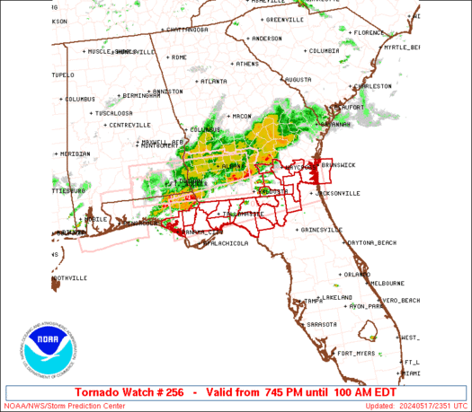
 URGENT - IMMEDIATE BROADCAST REQUESTED
Tornado Watch Number 256
NWS Storm Prediction Center Norman OK
745 PM EDT Fri May 17 2024 The NWS Storm Prediction Center has issued a * Tornado Watch for portions of North Florida and Panhandle Southeast Georgia Coastal Waters * Effective this Friday night and Saturday morning from 745 PM until 100 AM EDT. * Primary threats include... A couple tornadoes possible Scattered damaging wind gusts to 70 mph possible Isolated large hail events to 1.5 inches in diameter possible SUMMARY...A broken band of severe thunderstorms will move
east-southeast into the Florida Panhandle and adjacent portions of
southeast Georgia and north Florida during this evening. In
addition to the risk for a couple of tornadoes, severe gusts 60-70
mph resulting in wind damage will be possible with any embedded
supercells or bowing segments, as they move east-southeast across
the Watch area. The tornado watch area is approximately along and 35 statute miles
north and south of a line from 25 miles south southeast of Brunswick
GA to 45 miles southwest of Marianna FL. For a complete depiction of
the watch see the associated watch outline update (WOUS64 KWNS
WOU6). PRECAUTIONARY/PREPAREDNESS ACTIONS... REMEMBER...A Tornado Watch means conditions are favorable for
tornadoes and severe thunderstorms in and close to the watch
area. Persons in these areas should be on the lookout for
threatening weather conditions and listen for later statements
and possible warnings. && OTHER WATCH INFORMATION...CONTINUE...WW 253...WW 254...WW 255... AVIATION...Tornadoes and a few severe thunderstorms with hail
surface and aloft to 1.5 inches. Extreme turbulence and surface wind
gusts to 60 knots. A few cumulonimbi with maximum tops to 450. Mean
storm motion vector 30030. ...Smith

Mexicoâs national forest commission reported 168 active wildfires have burned over a quarter of a million acres. Southerly winds help to send smoke northward towards Texas and the Gulf Coast. South Padre Island, Texas had the poorest air quality in the nation on Friday as readings were considered to be in the âunhealthyâ range.
WW 255 SEVERE TSTM MN ND SD 172230Z – 180500Z 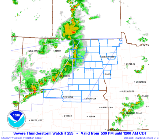
 URGENT - IMMEDIATE BROADCAST REQUESTED
Severe Thunderstorm Watch Number 255
NWS Storm Prediction Center Norman OK
530 PM CDT Fri May 17 2024 The NWS Storm Prediction Center has issued a * Severe Thunderstorm Watch for portions of Northwest Minnesota Eastern North Dakota Northern South Dakota * Effective this Friday afternoon from 530 PM until Midnight CDT. * Primary threats include... Scattered damaging wind gusts to 70 mph likely Isolated large hail events to 1.5 inches in diameter possible SUMMARY...A broken band of strong to severe thunderstorms will
likely move east into the Watch area during the evening from the
west. Severe gusts ranging from 60-70 mph and perhaps large hail
are the main threats with the more intense thunderstorms. The severe thunderstorm watch area is approximately along and 85
statute miles east and west of a line from 20 miles north of Hallock
MN to 20 miles east southeast of Mobridge SD. For a complete
depiction of the watch see the associated watch outline update
(WOUS64 KWNS WOU5). PRECAUTIONARY/PREPAREDNESS ACTIONS... REMEMBER...A Severe Thunderstorm Watch means conditions are
favorable for severe thunderstorms in and close to the watch area.
Persons in these areas should be on the lookout for threatening
weather conditions and listen for later statements and possible
warnings. Severe thunderstorms can and occasionally do produce
tornadoes. && OTHER WATCH INFORMATION...CONTINUE...WW 253...WW 254... AVIATION...A few severe thunderstorms with hail surface and aloft to
1.5 inches. Extreme turbulence and surface wind gusts to 60 knots. A
few cumulonimbi with maximum tops to 400. Mean storm motion vector
25035. ...Smith

We are on the backside of some very nasty weather that has affected the Lone Star state. Houston will be cleaning up for quite some time in the wake of hurricane force winds yesterday. Our thoughts and prayers are with the loved ones of those who perished from these storms. The heat cranks back up […]
WW 254 TORNADO AL FL GA 172000Z – 180300Z 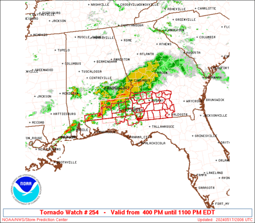
 URGENT - IMMEDIATE BROADCAST REQUESTED
Tornado Watch Number 254
NWS Storm Prediction Center Norman OK
400 PM EDT Fri May 17 2024 The NWS Storm Prediction Center has issued a * Tornado Watch for portions of Southeast Alabama Northern Florida Panhandle Southwest Georgia * Effective this Friday afternoon and evening from 400 PM until 1100 PM EDT. * Primary threats include... A few tornadoes possible Scattered large hail likely with isolated very large hail events to 2 inches in diameter possible Scattered damaging wind gusts to 70 mph likely SUMMARY...Thunderstorms will intensify this afternoon along a
surface boundary and track eastward across the watch area. Locally
severe storms are expected, with damaging winds, hail, and a few
tornadoes possible. The tornado watch area is approximately along and 35 statute miles
north and south of a line from 75 miles west of Dothan AL to 30
miles east northeast of Moultrie GA. For a complete depiction of the
watch see the associated watch outline update (WOUS64 KWNS WOU4). PRECAUTIONARY/PREPAREDNESS ACTIONS... REMEMBER...A Tornado Watch means conditions are favorable for
tornadoes and severe thunderstorms in and close to the watch
area. Persons in these areas should be on the lookout for
threatening weather conditions and listen for later statements
and possible warnings. && OTHER WATCH INFORMATION...CONTINUE...WW 253... AVIATION...Tornadoes and a few severe thunderstorms with hail
surface and aloft to 2 inches. Extreme turbulence and surface wind
gusts to 60 knots. A few cumulonimbi with maximum tops to 500. Mean
storm motion vector 27030. ...Hart