Tornado
SPC Severe Thunderstorm Watch 205
WW 205 SEVERE TSTM TX 012140Z – 020500Z 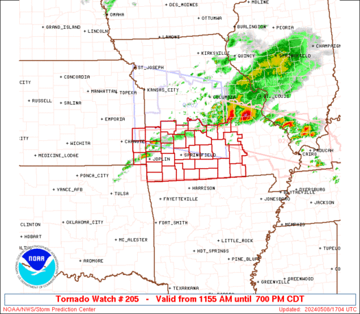
 URGENT - IMMEDIATE BROADCAST REQUESTED
Severe Thunderstorm Watch Number 205
NWS Storm Prediction Center Norman OK
440 PM CDT Thu May 1 2025 The NWS Storm Prediction Center has issued a * Severe Thunderstorm Watch for portions of South-Central and South Texas * Effective this Thursday afternoon from 440 PM until Midnight CDT. * Primary threats include... Scattered damaging winds and isolated significant gusts to 75 mph possible Scattered large hail and isolated very large hail events to 3.5 inches in diameter possible SUMMARY...Isolated to widely scattered thunderstorms are forecast to
develop through the late afternoon and into the evening. A very
unstable airmass and adequate deep-layer shear will promote
supercell development. Large to giant hail is possible with the
stronger storms. By this evening, a few storms may congeal and move
east of the Rio Grande into parts of south Texas, posing a risk for
large hail and severe gusts. The severe thunderstorm watch area is approximately along and 80
statute miles east and west of a line from 15 miles northwest of
Junction TX to 50 miles west southwest of Laredo TX. For a complete
depiction of the watch see the associated watch outline update
(WOUS64 KWNS WOU5). PRECAUTIONARY/PREPAREDNESS ACTIONS... REMEMBER...A Severe Thunderstorm Watch means conditions are
favorable for severe thunderstorms in and close to the watch area.
Persons in these areas should be on the lookout for threatening
weather conditions and listen for later statements and possible
warnings. Severe thunderstorms can and occasionally do produce
tornadoes. && OTHER WATCH INFORMATION...CONTINUE...WW 203...WW 204... AVIATION...A few severe thunderstorms with hail surface and aloft to
3.5 inches. Extreme turbulence and surface wind gusts to 65 knots. A
few cumulonimbi with maximum tops to 600. Mean storm motion vector
31010. ...Smith
LIVE Now: Severe Thunderstorms and Tornadoes in Texas | Breaking Weather UpdatesExternalInbox

LIVE Texas Severe Weather Coverage {Baldy-in-Chief David Reimer @texasstormchasers} for May 1, 2025. We will focus on the most intense storms to keep you informed, without the hype, and ahead of the storm. Remember, knowledge is power – and with that, you are already in better shape than those who may not know storms are […]
Florida citrus production drops as growers battle weather, disease to survive

Weather and disease have posed significant challenges for Florida farmers.
SPC Severe Thunderstorm Watch 204
WW 204 SEVERE TSTM TX 011930Z – 020200Z 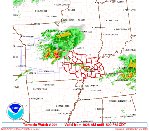
 URGENT - IMMEDIATE BROADCAST REQUESTED
Severe Thunderstorm Watch Number 204
NWS Storm Prediction Center Norman OK
230 PM CDT Thu May 1 2025 The NWS Storm Prediction Center has issued a * Severe Thunderstorm Watch for portions of Central Texas * Effective this Thursday afternoon and evening from 230 PM until 900 PM CDT. * Primary threats include... Scattered large hail and isolated very large hail events to 2.5 inches in diameter likely Scattered damaging wind gusts to 70 mph likely SUMMARY...Isolated but intense thunderstorms are expected to form
this afternoon in a very moist and unstable air mass. Slow-moving
supercells capable of very large hail appear to be the main concern. The severe thunderstorm watch area is approximately along and 40
statute miles north and south of a line from 115 miles west of
Temple TX to 65 miles east southeast of Temple TX. For a complete
depiction of the watch see the associated watch outline update
(WOUS64 KWNS WOU4). PRECAUTIONARY/PREPAREDNESS ACTIONS... REMEMBER...A Severe Thunderstorm Watch means conditions are
favorable for severe thunderstorms in and close to the watch area.
Persons in these areas should be on the lookout for threatening
weather conditions and listen for later statements and possible
warnings. Severe thunderstorms can and occasionally do produce
tornadoes. && OTHER WATCH INFORMATION...CONTINUE...WW 203... AVIATION...A few severe thunderstorms with hail surface and aloft to
2.5 inches. Extreme turbulence and surface wind gusts to 60 knots. A
few cumulonimbi with maximum tops to 500. Mean storm motion vector
24035. ...Hart
Watch: Drone video shows shark annoyed by fish chasing it along Florida Gulf Coast

Drone video of a shark being chased by three fish was making big waves in the southwest Florida town of Dunedin.
Bald eagle chicks rescued from sinking nest in Missouri river

Two bald eagle chicks were saved from a river in Missouri ahead of storms this week.
Northeast faces another wet weekend as back-to-back storms threaten

If the weekend forecast in the Northeast sounds familiar, thatâs because it is. More rain and thunderstorms are expected across the region, marking the sixth out of the past seven weekends that precipitation is in the forecast.
The Daily Weather Update from FOX Weather: Severe storms kick off May with hurricane season looming in a month

Top weather news for Thursday, May 1, 2025: Relentless severe weather is forecast to slam the central U.S. and Ohio Valley once again. Meanwhile, interesting developments are taking place in the Atlantic Basin one month before the start of hurricane season.