SPC Severe Thunderstorm Watch 273

WW 273 SEVERE TSTM OH VA WV 170330Z – 170900Z
WW 0273 Image

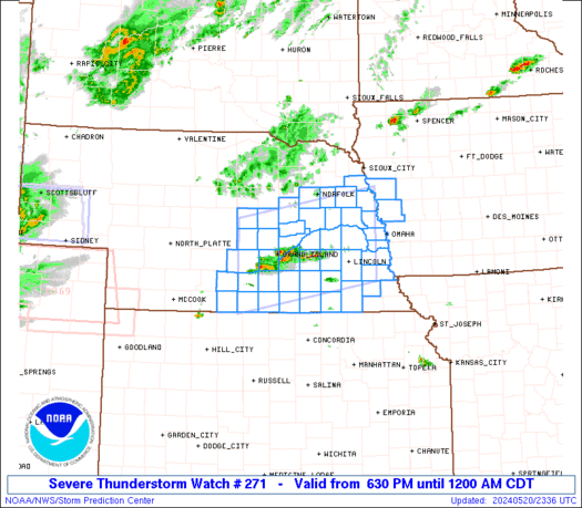
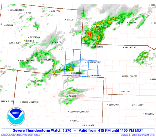
 URGENT - IMMEDIATE BROADCAST REQUESTED
Severe Thunderstorm Watch Number 273
NWS Storm Prediction Center Norman OK
1130 PM EDT Fri May 16 2025 The NWS Storm Prediction Center has issued a * Severe Thunderstorm Watch for portions of Far Southeast Ohio Western Virginia West Virginia * Effective this Friday night and Saturday morning from 1130 PM until 500 AM EDT. * Primary threats include... Scattered damaging wind gusts to 70 mph likely Isolated large hail events to 1.5 inches in diameter possible A tornado or two possible SUMMARY...Clusters of thunderstorms should spread eastward overnight
while posing a threat for mainly scattered severe/damaging winds,
with peak gusts up to 60-70 mph. Isolated hail and perhaps a tornado
or two may also occur. The severe thunderstorm watch area is approximately along and 50
statute miles east and west of a line from 35 miles east northeast
of Parkersburg WV to 5 miles west southwest of Bluefield WV. For a
complete depiction of the watch see the associated watch outline
update (WOUS64 KWNS WOU3). PRECAUTIONARY/PREPAREDNESS ACTIONS... REMEMBER...A Severe Thunderstorm Watch means conditions are
favorable for severe thunderstorms in and close to the watch area.
Persons in these areas should be on the lookout for threatening
weather conditions and listen for later statements and possible
warnings. Severe thunderstorms can and occasionally do produce
tornadoes. && OTHER WATCH INFORMATION...CONTINUE...WW 267...WW 269...WW
270...WW 271...WW 272... AVIATION...A few severe thunderstorms with hail surface and aloft to
1.5 inches. Extreme turbulence and surface wind gusts to 60 knots. A
few cumulonimbi with maximum tops to 500. Mean storm motion vector
27040. ...Gleason 

Read more

SPC Tornado Watch 271

WW 271 TORNADO TN VA 170135Z – 170800Z
WW 0271 Image

 URGENT - IMMEDIATE BROADCAST REQUESTED
Tornado Watch Number 271
NWS Storm Prediction Center Norman OK
835 PM CDT Fri May 16 2025 The NWS Storm Prediction Center has issued a * Tornado Watch for portions of Middle and Eastern Tennessee Far Southwest Virginia * Effective this Friday night and Saturday morning from 835 PM until 300 AM CDT. * Primary threats include... A few tornadoes likely with a couple intense tornadoes possible Scattered damaging winds likely with isolated significant gusts to 75 mph possible Scattered large hail and isolated very large hail events to 2 inches in diameter possible SUMMARY...Both supercells and a line of thunderstorms should pose a
threat for a few tornadoes this evening and overnight as they spread
east-southeastward. A strong tornado remains possible, especially
with any supercell that can be maintained ahead of the line.
Scattered severe/damaging winds appear likely, with peak gusts
potentially reaching up to 60-75 mph. Occasional large hail may also
occur. The tornado watch area is approximately along and 40 statute miles
north and south of a line from 80 miles west southwest of Nashville
TN to 45 miles east northeast of Knoxville TN. For a complete
depiction of the watch see the associated watch outline update
(WOUS64 KWNS WOU1). PRECAUTIONARY/PREPAREDNESS ACTIONS... REMEMBER...A Tornado Watch means conditions are favorable for
tornadoes and severe thunderstorms in and close to the watch
area. Persons in these areas should be on the lookout for
threatening weather conditions and listen for later statements
and possible warnings. && OTHER WATCH INFORMATION...CONTINUE...WW 265...WW 267...WW
268...WW 269...WW 270... AVIATION...Tornadoes and a few severe thunderstorms with hail
surface and aloft to 2 inches. Extreme turbulence and surface wind
gusts to 65 knots. A few cumulonimbi with maximum tops to 500. Mean
storm motion vector 28035. ...Gleason 

Read more

SPC Tornado Watch 270

WW 270 TORNADO AR MO MS TN 162350Z – 170700Z
WW 0270 Image

 URGENT - IMMEDIATE BROADCAST REQUESTED
Tornado Watch Number 270
NWS Storm Prediction Center Norman OK
650 PM CDT Fri May 16 2025 The NWS Storm Prediction Center has issued a * Tornado Watch for portions of Northern and Central Arkansas The Missouri Bootheel Far Northern Mississippi Western Tennessee * Effective this Friday night and Saturday morning from 650 PM until 200 AM CDT. * Primary threats include... A few tornadoes likely with a couple intense tornadoes possible Scattered large hail and isolated very large hail events to 3 inches in diameter likely Scattered damaging winds likely with isolated significant gusts to 75 mph possible SUMMARY...Multiple supercell thunderstorms should pose a threat for
a few tornadoes this evening, with a strong tornado possible with
any persistent supercell. Otherwise, large to very large hail (up to
2-3 inches in diameter) along with scattered to numerous
severe/damaging winds also appear likely. Peak gusts may reach up to
65-75 mph if a line of thunderstorms can form later this evening. The tornado watch area is approximately along and 60 statute miles
north and south of a line from 5 miles south southwest of
Russellville AR to 50 miles east of Jackson TN. For a complete
depiction of the watch see the associated watch outline update
(WOUS64 KWNS WOU0). PRECAUTIONARY/PREPAREDNESS ACTIONS... REMEMBER...A Tornado Watch means conditions are favorable for
tornadoes and severe thunderstorms in and close to the watch
area. Persons in these areas should be on the lookout for
threatening weather conditions and listen for later statements
and possible warnings. && OTHER WATCH INFORMATION...CONTINUE...WW 262...WW 264...WW
265...WW 266...WW 267...WW 268...WW 269... AVIATION...Tornadoes and a few severe thunderstorms with hail
surface and aloft to 3 inches. Extreme turbulence and surface wind
gusts to 65 knots. A few cumulonimbi with maximum tops to 600. Mean
storm motion vector 27035. ...Gleason 

Read more