Small rain chances today & tomorrow, before it dries out
Isolated activity today, a few more showers along a front tomorrow.
24/7 Tornado Newsfeed
Isolated activity today, a few more showers along a front tomorrow.
No watches are valid as of Wed May 7 05:07:02 UTC 2025.

A black bear was spotted roaming downtown St. Augustine, Florida, on Tuesday morning, prompting safety warnings from local police and wildlife officials. Authorities say the bear is not a threat but urge residents to keep a safe distance from the animal.
WW 236 SEVERE TSTM TX CW 070100Z – 070500Z 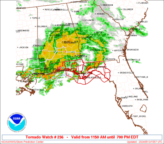
 URGENT - IMMEDIATE BROADCAST REQUESTED
Severe Thunderstorm Watch Number 236
NWS Storm Prediction Center Norman OK
800 PM CDT Tue May 6 2025 The NWS Storm Prediction Center has issued a * Severe Thunderstorm Watch for portions of South Texas Coastal Waters * Effective this Tuesday night from 800 PM until Midnight CDT. * Primary threats include... Scattered large hail and isolated very large hail events to 3 inches in diameter possible Isolated damaging wind gusts to 70 mph possible SUMMARY...A few supercells are forecast to develop this evening and
pose mainly a threat for large to very large hail. The severe thunderstorm watch area is approximately along and 55
statute miles east and west of a line from 25 miles north of
Beeville TX to 25 miles west southwest of Mcallen TX. For a complete
depiction of the watch see the associated watch outline update
(WOUS64 KWNS WOU6). PRECAUTIONARY/PREPAREDNESS ACTIONS... REMEMBER...A Severe Thunderstorm Watch means conditions are
favorable for severe thunderstorms in and close to the watch area.
Persons in these areas should be on the lookout for threatening
weather conditions and listen for later statements and possible
warnings. Severe thunderstorms can and occasionally do produce
tornadoes. && OTHER WATCH INFORMATION...CONTINUE...WW 234...WW 235... AVIATION...A few severe thunderstorms with hail surface and aloft to
3 inches. Extreme turbulence and surface wind gusts to 60 knots. A
few cumulonimbi with maximum tops to 600. Mean storm motion vector
29030. ...Smith

A kayaker was attacked by an alligator Tuesday afternoon at Lake Kissimmee State Park in Central Florida, according to the Polk County Sheriffâs Office.

Cicadas of Brood XIV have begun to emerge this spring, starting in the Southeast and making their way to the Northeast.

NASA and the European Space Agency recently shared an image of an oddly shaped spiral galaxy located about 190 million light-years away.
WW 235 TORNADO LA MS 062210Z – 070600Z 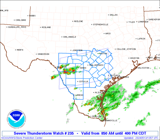
 URGENT - IMMEDIATE BROADCAST REQUESTED
Tornado Watch Number 235
NWS Storm Prediction Center Norman OK
510 PM CDT Tue May 6 2025 The NWS Storm Prediction Center has issued a * Tornado Watch for portions of Northeast into Southeast Louisiana Southwest into Central Mississippi * Effective this Tuesday afternoon and Wednesday morning from 510 PM until 100 AM CDT. * Primary threats include... A couple tornadoes possible Scattered damaging wind gusts to 70 mph possible Scattered large hail events to 1.5 inches in diameter possible SUMMARY...Scattered to numerous thunderstorms are forecast to
develop and move into the Watch area this evening into the early
overnight. A few supercells and line segments will likely focus the
severe thunderstorm and tornado risks. A couple of tornadoes are
possible with the more intense thunderstorms, as well as damaging
gusts and large hail. The tornado watch area is approximately along and 60 statute miles
east and west of a line from 60 miles east northeast of Monroe LA to
75 miles south southwest of Mc Comb MS. For a complete depiction of
the watch see the associated watch outline update (WOUS64 KWNS
WOU5). PRECAUTIONARY/PREPAREDNESS ACTIONS... REMEMBER...A Tornado Watch means conditions are favorable for
tornadoes and severe thunderstorms in and close to the watch
area. Persons in these areas should be on the lookout for
threatening weather conditions and listen for later statements
and possible warnings. && OTHER WATCH INFORMATION...CONTINUE...WW 233...WW 234... AVIATION...Tornadoes and a few severe thunderstorms with hail
surface and aloft to 1.5 inches. Extreme turbulence and surface wind
gusts to 60 knots. A few cumulonimbi with maximum tops to 500. Mean
storm motion vector 24035. ...Smith