Tornado
SPC Severe Thunderstorm Watch 679
WW 679 SEVERE TSTM KS MO OK 192230Z – 200500Z 
 URGENT - IMMEDIATE BROADCAST REQUESTED
Severe Thunderstorm Watch Number 679
NWS Storm Prediction Center Norman OK
530 PM CDT Thu Sep 19 2024 The NWS Storm Prediction Center has issued a * Severe Thunderstorm Watch for portions of Southeast Kansas Western Missouri Northeast Oklahoma * Effective this Thursday afternoon from 530 PM until Midnight CDT. * Primary threats include... Scattered damaging winds and isolated significant gusts to 75 mph possible Isolated large hail events to 1.5 inches in diameter possible SUMMARY...Scattered thunderstorms are expected to continue to
intensify through the evening across southeast Kansas and northern
Oklahoma, spreading into parts of western Missouri through the
evening. Damaging winds and some hail are the main concerns. The severe thunderstorm watch area is approximately along and 60
statute miles east and west of a line from 30 miles south of
Bartlesville OK to 100 miles north northeast of Joplin MO. For a
complete depiction of the watch see the associated watch outline
update (WOUS64 KWNS WOU9). PRECAUTIONARY/PREPAREDNESS ACTIONS... REMEMBER...A Severe Thunderstorm Watch means conditions are
favorable for severe thunderstorms in and close to the watch area.
Persons in these areas should be on the lookout for threatening
weather conditions and listen for later statements and possible
warnings. Severe thunderstorms can and occasionally do produce
tornadoes. && OTHER WATCH INFORMATION...CONTINUE...WW 677...WW 678... AVIATION...A few severe thunderstorms with hail surface and aloft to
1.5 inches. Extreme turbulence and surface wind gusts to 65 knots. A
few cumulonimbi with maximum tops to 500. Mean storm motion vector
28025. ...Hart
Fall foliage tracker: Where and when to see the most brilliant colors across the US

Fall foliage is highly contingent on location and weather conditions in the weeks and months before the height of the season. Changes in leaves start occurring when trees start to receive less sunlight. The lack of chlorophyll can reveal yellow, orange, and red pigments, leading to the best fall foliage colors.
SpaceX prepares for first NASA astronaut launch from Florida military launchpad

SpaceX is targeting to launch Crew-9, NASA's ninth commercial crew spaceflight, from Florida no earlier than late September, and this mission will be unique for two reasons.
SPC Tornado Watch 678
WW 678 TORNADO MN WI LS 192205Z – 200400Z 
 URGENT - IMMEDIATE BROADCAST REQUESTED
Tornado Watch Number 678
NWS Storm Prediction Center Norman OK
505 PM CDT Thu Sep 19 2024 The NWS Storm Prediction Center has issued a * Tornado Watch for portions of Northeast Minnesota Northwest Wisconsin Lake Superior * Effective this Thursday afternoon and evening from 505 PM until 1100 PM CDT. * Primary threats include... A couple tornadoes possible Scattered damaging wind gusts to 70 mph possible Scattered large hail events to 1.5 inches in diameter possible SUMMARY...Scattered thunderstorms will continue to develop across
northeastern Minnesota and track eastward across the watch area this
evening. Isolated intense/supercells are possible, capable of hail,
damaging winds, and a tornado or two. The tornado watch area is approximately along and 50 statute miles
east and west of a line from 40 miles north northwest of Grand
Marais MN to 85 miles south of Duluth MN. For a complete depiction
of the watch see the associated watch outline update (WOUS64 KWNS
WOU8). PRECAUTIONARY/PREPAREDNESS ACTIONS... REMEMBER...A Tornado Watch means conditions are favorable for
tornadoes and severe thunderstorms in and close to the watch
area. Persons in these areas should be on the lookout for
threatening weather conditions and listen for later statements
and possible warnings. && OTHER WATCH INFORMATION...CONTINUE...WW 677... AVIATION...Tornadoes and a few severe thunderstorms with hail
surface and aloft to 1.5 inches. Extreme turbulence and surface wind
gusts to 60 knots. A few cumulonimbi with maximum tops to 500. Mean
storm motion vector 23035. ...Hart
Hundreds of stinging creatures wash up on Texas beaches

Moon jellyfish have been spotted washed up on the beaches or floating in the waters of the Gulf of Mexico in recent days.
See it: Lucky seal survives nearly becoming humpback whale’s lunch in Washington

A seal miraculously survived after getting scooped up into a humpback whale's mouth last week, leading to an incredible photo from whale watchers on a nearby boat tour in western Washington last week.
SPC Severe Thunderstorm Watch 677
WW 677 SEVERE TSTM IA MN WI 191910Z – 200300Z 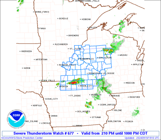
 URGENT - IMMEDIATE BROADCAST REQUESTED
Severe Thunderstorm Watch Number 677
NWS Storm Prediction Center Norman OK
210 PM CDT Thu Sep 19 2024 The NWS Storm Prediction Center has issued a * Severe Thunderstorm Watch for portions of Northern Iowa Southern and East-Central Minnesota Western Wisconsin * Effective this Thursday afternoon and evening from 210 PM until 1000 PM CDT. * Primary threats include... Scattered large hail likely with isolated very large hail events to 2.5 inches in diameter possible Scattered damaging wind gusts to 70 mph possible A tornado or two possible SUMMARY...Thunderstorms should continue to develop this afternoon
while posing a threat for large hail up to 1.5-2.5 inches in
diameter. As this activity spreads east-northeastward, damaging
winds around 60-70 mph may become more of a threat through this
evening, especially if thunderstorms can form into clusters. A
tornado or two also appears possible with any persistent,
surface-based supercell. The severe thunderstorm watch area is approximately along and 75
statute miles east and west of a line from 45 miles north northwest
of Eau Claire WI to 15 miles southwest of Mason City IA. For a
complete depiction of the watch see the associated watch outline
update (WOUS64 KWNS WOU7). PRECAUTIONARY/PREPAREDNESS ACTIONS... REMEMBER...A Severe Thunderstorm Watch means conditions are
favorable for severe thunderstorms in and close to the watch area.
Persons in these areas should be on the lookout for threatening
weather conditions and listen for later statements and possible
warnings. Severe thunderstorms can and occasionally do produce
tornadoes. && AVIATION...A few severe thunderstorms with hail surface and aloft to
2.5 inches. Extreme turbulence and surface wind gusts to 60 knots. A
few cumulonimbi with maximum tops to 500. Mean storm motion vector
24030. ...Gleason