SPC – No watches are valid as of Sat Apr 5 10:48:02 UTC 2025
No watches are valid as of Sat Apr 5 10:48:02 UTC 2025.
24/7 Tornado Newsfeed
No watches are valid as of Sat Apr 5 10:48:02 UTC 2025.

Life-threatening flooding and dangerous severe weather pummeled large swaths of the nation's heartland again Friday night for the third night in a row, and Saturday is shaping up to be just as bad, if not worse, for some areas with worries of heavy rainfall not seen in generations.
Storms could interrupt free concerts tonight, then much cooler over the weekend.
WW 121 SEVERE TSTM TX 050400Z – 051000Z 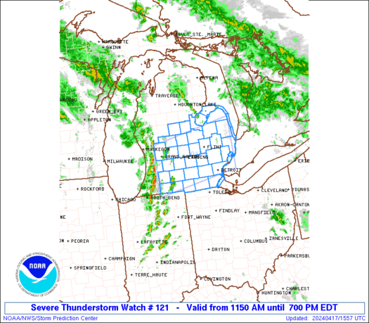
 URGENT - IMMEDIATE BROADCAST REQUESTED
Severe Thunderstorm Watch Number 121
NWS Storm Prediction Center Norman OK
1100 PM CDT Fri Apr 4 2025 The NWS Storm Prediction Center has issued a * Severe Thunderstorm Watch for portions of Central Texas * Effective this Friday night and Saturday morning from 1100 PM until 500 AM CDT. * Primary threats include... Scattered large hail and isolated very large hail events to 2.5 inches in diameter likely Scattered damaging wind gusts to 70 mph likely SUMMARY...Thunderstorms are expected to rapidly intensify across
central Texas and affect the watch area through the early morning
hours. Large hail is the main concern with these storms. The severe thunderstorm watch area is approximately along and 80
statute miles north and south of a line from 70 miles northwest of
Del Rio TX to 50 miles north of Austin TX. For a complete depiction
of the watch see the associated watch outline update (WOUS64 KWNS
WOU1). PRECAUTIONARY/PREPAREDNESS ACTIONS... REMEMBER...A Severe Thunderstorm Watch means conditions are
favorable for severe thunderstorms in and close to the watch area.
Persons in these areas should be on the lookout for threatening
weather conditions and listen for later statements and possible
warnings. Severe thunderstorms can and occasionally do produce
tornadoes. && OTHER WATCH INFORMATION...CONTINUE...WW 119...WW 120... AVIATION...A few severe thunderstorms with hail surface and aloft to
2.5 inches. Extreme turbulence and surface wind gusts to 60 knots. A
few cumulonimbi with maximum tops to 500. Mean storm motion vector
24030. ...Hart
WW 120 TORNADO IL IN KY MO 050240Z – 050900Z 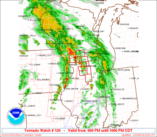
 URGENT - IMMEDIATE BROADCAST REQUESTED
Tornado Watch Number 120
NWS Storm Prediction Center Norman OK
940 PM CDT Fri Apr 4 2025 The NWS Storm Prediction Center has issued a * Tornado Watch for portions of Southeast Illinois Southwest Indiana Western Kentucky Southeast Missouri * Effective this Friday night and Saturday morning from 940 PM until 400 AM CDT. * Primary threats include... A few tornadoes likely with a couple intense tornadoes possible Scattered damaging wind gusts to 70 mph likely Scattered large hail events to 1.5 inches in diameter likely SUMMARY...Multiple clusters of strong/severe thunderstorms are
tracking eastward into the watch area. These storms will maintain
some concern for damaging winds and a few tornadoes for several more
hours. The tornado watch area is approximately along and 60 statute miles
east and west of a line from 40 miles south southwest of Paducah KY
to 45 miles west northwest of Owensboro KY. For a complete depiction
of the watch see the associated watch outline update (WOUS64 KWNS
WOU0). PRECAUTIONARY/PREPAREDNESS ACTIONS... REMEMBER...A Tornado Watch means conditions are favorable for
tornadoes and severe thunderstorms in and close to the watch
area. Persons in these areas should be on the lookout for
threatening weather conditions and listen for later statements
and possible warnings. && OTHER WATCH INFORMATION...CONTINUE...WW 115...WW 118...WW 119... AVIATION...Tornadoes and a few severe thunderstorms with hail
surface and aloft to 1.5 inches. Extreme turbulence and surface wind
gusts to 60 knots. A few cumulonimbi with maximum tops to 500. Mean
storm motion vector 24035. ...Hart
WW 119 TORNADO AR LA MO TN TX 050150Z – 050900Z 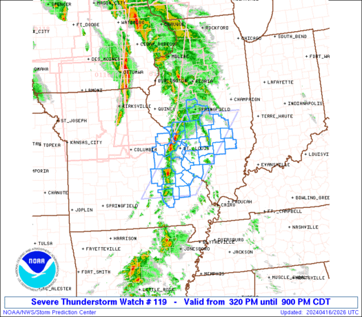
 URGENT - IMMEDIATE BROADCAST REQUESTED
Tornado Watch Number 119
NWS Storm Prediction Center Norman OK
850 PM CDT Fri Apr 4 2025 The NWS Storm Prediction Center has issued a * Tornado Watch for portions of Arkansas Northwest Louisiana Missouri Bootheel Northwest Tennessee Northeast Texas * Effective this Friday night and Saturday morning from 850 PM until 400 AM CDT. * Primary threats include... A few tornadoes and a couple intense tornadoes likely Scattered damaging wind gusts to 70 mph likely Scattered large hail and isolated very large hail events to 2 inches in diameter possible SUMMARY...A line of occasionally intense thunderstorms with embedded
supercells will track slowly eastward across the watch area
overnight. Favorable instability and shear profiles will maintain a
risk of a few tornadoes, along with damaging winds and large hail. The tornado watch area is approximately along and 55 statute miles
east and west of a line from 30 miles south of Longview TX to 40
miles northeast of Walnut Ridge AR. For a complete depiction of the
watch see the associated watch outline update (WOUS64 KWNS WOU9). PRECAUTIONARY/PREPAREDNESS ACTIONS... REMEMBER...A Tornado Watch means conditions are favorable for
tornadoes and severe thunderstorms in and close to the watch
area. Persons in these areas should be on the lookout for
threatening weather conditions and listen for later statements
and possible warnings. && OTHER WATCH INFORMATION...CONTINUE...WW 113...WW 115...WW 118... AVIATION...Tornadoes and a few severe thunderstorms with hail
surface and aloft to 2 inches. Extreme turbulence and surface wind
gusts to 60 knots. A few cumulonimbi with maximum tops to 500. Mean
storm motion vector 23035. ...Hart

For the second time in less than a decade, a tornado has reportedly caused significant damage to a bottling plant in East Texas.