Note:
The expiration time in the watch graphic is amended if the watch is
replaced, cancelled or extended.
Note: Click for Watch Status Reports.
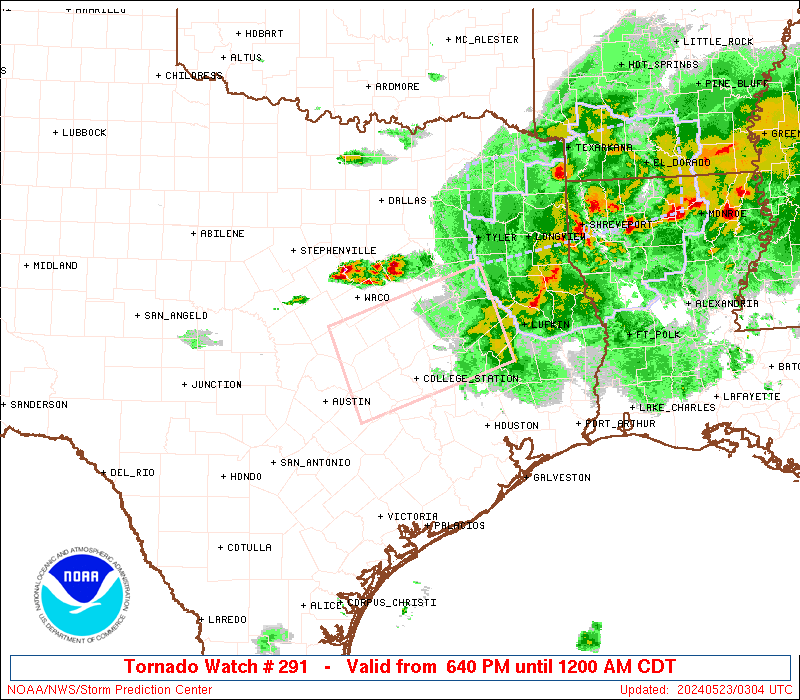
SEL1 URGENT - IMMEDIATE BROADCAST REQUESTED Tornado Watch Number 291 NWS Storm Prediction Center Norman OK 640 PM CDT Wed May 22 2024 The NWS Storm Prediction Center has issued a * Tornado Watch for portions of Central and southeast Texas * Effective this Wednesday night from 640 PM until Midnight CDT. * Primary threats include... A couple tornadoes possible Scattered damaging winds likely with isolated significant gusts to 80 mph possible Scattered large hail and isolated very large hail events to 2 inches in diameter possible SUMMARY...A large supercell cluster with a history of severe wind gusts/hail will likely continue east-southeastward for the next few hours. The storm environment will favor gusts up to 80 mph and large hail of 1-2 inches in diameter, in addition to the potential for a couple of tornadoes with embedded circulations. The tornado watch area is approximately along and 45 statute miles either side of a line from 35 miles south of Temple TX to 50 miles north northeast of Huntsville TX. For a complete depiction of the watch see the associated watch outline update (WOUS64 KWNS WOU1). PRECAUTIONARY/PREPAREDNESS ACTIONS... REMEMBER...A Tornado Watch means conditions are favorable for tornadoes and severe thunderstorms in and close to the watch area. Persons in these areas should be on the lookout for threatening weather conditions and listen for later statements and possible warnings. && OTHER WATCH INFORMATION...CONTINUE...WW 286...WW 287...WW 288...WW 289...WW 290... AVIATION...Tornadoes and a few severe thunderstorms with hail surface and aloft to 2 inches. Extreme turbulence and surface wind gusts to 70 knots. A few cumulonimbi with maximum tops to 600. Mean storm motion vector 29025. ...Thompson