
The coldest weather of winter will directly impact Texas this week, with dangerously cold conditions expected to begin Tuesday and continue through Friday. The northern third of Texas will likely spend at least a day and a half to two days below freezing. Low temperatures below zero are expected in the Panhandle, with wind chills reaching twenty degrees below zero. The northern half of Texas will experience wind chills below zero or in the single digits, along with very cold overnight temperatures.
This event will require some cold weather preparation—so please remember your people, pets, pipes, and plants! Compared to 2021, this event will last two to three days, with most folks rising above freezing each afternoon. We’re also not expecting the entire state to be covered in ice and snow; however, overnight temperatures will be extremely cold across the northern third to half of Texas.
Advertisements
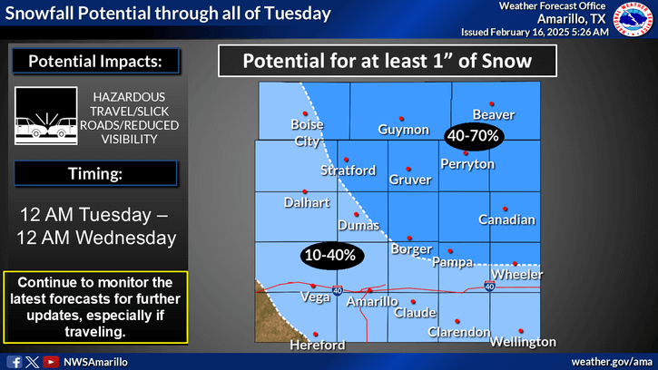


Light snow is possible on Tuesday and Tuesday night in the Texas Panhandle. Significant accumulations are unlikely, but perhaps up to one inch of snow could fall in the northeastern sections of the Oklahoma Panhandle. Given that temperatures will be in the single digits and teens, any snow that falls will stick around for a while.
Farther southeast, a light glaze of ice may develop in Northwest Texas, Big Country, Texoma, and Northeast Texas. For now, we’re highlighting the ‘ice’ threat along and north of Highway 380 in North Texas, particularly in the northern D/FW Metroplex. Since we’re four days out, you can bet that will change. It could easily shift south to include all of D/FW, or if we end up drier, we might not have any issues at all. Regardless, at least minor travel disruptions are possible from Tuesday afternoon through Wednesday morning in the aforementioned regions. This would primarily impact some bridges and overpasses, and perhaps a few slick roads.
Given the very cold air mass in place, we will have to closely monitor any freezing drizzle/rain for travel impacts—even though the amounts will be very light. Rain and storms are possible across the eastern half of Texas, with a few strong storms with hail possible in Southeast Texas, the Upper Texas Gulf Coast, and the Golden Triangle on Tuesday night. All precipitation should exit Texas Wednesday afternoon, with very cold temperatures continuing through Friday. A significant warm-up will begin this weekend, with temperatures quickly returning to the 60s, 70s, and 80s.
Advertisements
Check out our current LIVE STREAM: https://texasweather.video/
Interactive Weather Radar: https://texastormchasers.com/radar/
Our FREE WEATHER APP: https://texasweather.app/
GET ALERTED when in danger of severe storms and tornadoes! https://weathercallservices.com/tx-storm-chasers-nexgen
Our SOCIAL PLATFORMS: https://linktr.ee/texasstormchasers