Note:
The expiration time in the watch graphic is amended if the watch is
replaced, cancelled or extended.
Note: Click for Watch Status Reports.
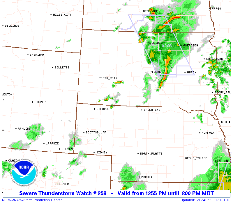
SEL9 URGENT - IMMEDIATE BROADCAST REQUESTED Severe Thunderstorm Watch Number 259 NWS Storm Prediction Center Norman OK 1255 PM MDT Sun May 19 2024 The NWS Storm Prediction Center has issued a * Severe Thunderstorm Watch for portions of Northeast Colorado Western Nebraska Western and Central South Dakota * Effective this Sunday afternoon and evening from 1255 PM until 800 PM MDT. * Primary threats include... Scattered large hail and isolated very large hail events to 2 inches in diameter possible Scattered damaging wind gusts to 70 mph possible SUMMARY...Thunderstorms are forming over parts of western South Dakota and Nebraska. These storms will spread eastward through the afternoon and early evening, posing a risk of locally damaging winds gusts and hail. The severe thunderstorm watch area is approximately along and 65 statute miles east and west of a line from 20 miles northwest of Mobridge SD to 40 miles southeast of Sidney NE. For a complete depiction of the watch see the associated watch outline update (WOUS64 KWNS WOU9). PRECAUTIONARY/PREPAREDNESS ACTIONS... REMEMBER...A Severe Thunderstorm Watch means conditions are favorable for severe thunderstorms in and close to the watch area. Persons in these areas should be on the lookout for threatening weather conditions and listen for later statements and possible warnings. Severe thunderstorms can and occasionally do produce tornadoes. && OTHER WATCH INFORMATION...CONTINUE...WW 258... AVIATION...A few severe thunderstorms with hail surface and aloft to 2 inches. Extreme turbulence and surface wind gusts to 60 knots. A few cumulonimbi with maximum tops to 500. Mean storm motion vector 25030. ...Hart