Note:
The expiration time in the watch graphic is amended if the watch is
replaced, cancelled or extended.
Note: Click for Watch Status Reports.
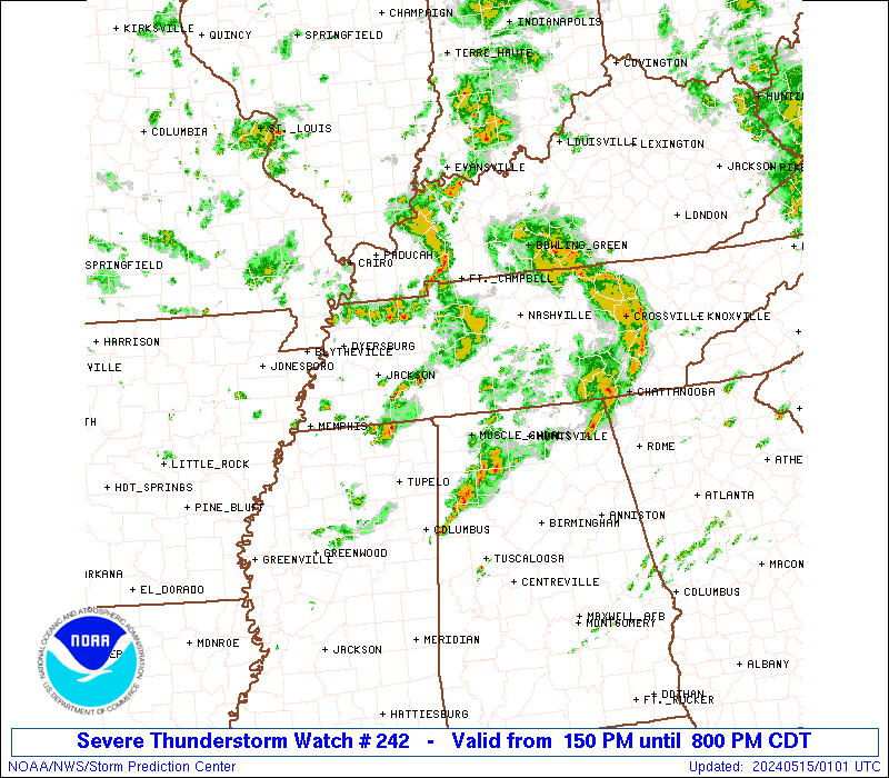
SEL2 URGENT - IMMEDIATE BROADCAST REQUESTED Severe Thunderstorm Watch Number 242 NWS Storm Prediction Center Norman OK 150 PM CDT Tue May 14 2024 The NWS Storm Prediction Center has issued a * Severe Thunderstorm Watch for portions of Northwest Alabama Northeast Mississippi Western and middle Tennessee * Effective this Tuesday afternoon and evening from 150 PM until 800 PM CDT. * Primary threats include... Isolated damaging wind gusts to 60 mph possible Isolated large hail events to 1.5 inches in diameter possible SUMMARY...Scattered thunderstorms will continue to form and spread east-northeastward from northern Mississippi and western Tennessee toward northwest Alabama and middle Tennessee through late afternoon/evening. The strongest clusters and/or storms with supercell structure will be capable of producing isolated large hail of 1-1.5 inches in diameter and isolated damaging winds near 60 mph. The severe thunderstorm watch area is approximately along and 65 statute miles east and west of a line from 35 miles southwest of Muscle Shoals AL to 35 miles northwest of Nashville TN. For a complete depiction of the watch see the associated watch outline update (WOUS64 KWNS WOU2). PRECAUTIONARY/PREPAREDNESS ACTIONS... REMEMBER...A Severe Thunderstorm Watch means conditions are favorable for severe thunderstorms in and close to the watch area. Persons in these areas should be on the lookout for threatening weather conditions and listen for later statements and possible warnings. Severe thunderstorms can and occasionally do produce tornadoes. && AVIATION...A few severe thunderstorms with hail surface and aloft to 1.5 inches. Extreme turbulence and surface wind gusts to 50 knots. A few cumulonimbi with maximum tops to 450. Mean storm motion vector 24025. ...Thompson